Showing posts with label rainfall. Show all posts

Wednesday 3 January 2024

New South Wales might still be in the grip of drought, however December rains did some good


Those rolling thunderstorms, wind, rain and flash flooding that plagued the state in December were not just uncomfortable - at times they were dangerous. 


Even now in the first two days of 2024 the NSW State Emergency Service (SES) has responded to more than 115 incidents in the past 24 hours, in response to the impacts of storms and flooding in the north east of the state.


However, all that weather has produced one set of images to bring smiles to the faces of some people in a number of coastal districts.


It's not enough to come out of drought but areas of intense drought have shrunk somewhat.


The Northern Rivers region has seen the Intense Drought category sink back down to 14.5 per cent from a Spring high of an est. 42.8 per cent of all land. While the Drought category fell from 41.6 per cent to 29.1 per cent, with those decreases moving over to being Drought Affected land sitting at 56.3 per cent of the region. 


This of course is 2024, the year of accelerated global warming and erratic weather patterns, so it feels like a coin toss as to whether the Australian east coast and the Northern Rivers in particular have three months of destructive storms ahead or a return to below average rainfall until Winter arrives.


NEW SOUTH WALES DROUGHT PERCENTAGES 29.12.23

NSWDPI Combined Drought Indicator


Wednesday 20 September 2023

The other shoe has finally dropped - El Niño has been declared by Australian Bureau of Meteorology


Click on image to enlarge


Central and eastern Pacific sea surface temperatures (SSTs) currently exceed El Niño thresholds. International climate models suggest some further warming of the central and eastern tropical Pacific Ocean is likely. All surveyed models indicate SSTs will remain above El Niño thresholds until at least the end of the 2023–24 southern hemisphere summer.

Bureau long-range forecasts are for SSTs up to 2.5 °C warmer than average off eastern Tasmania and in the eastern Tasman Sea from October to the end of 2023.


Click on image to enlarge


Australian Bureau of Meteorology, 19 September 2023:


ElNiño and positive Indian Ocean Dipole underway


An El Niño and a positive IOD are underway.


The declaration of these events, and their concurrence over spring, reinforces the Bureau's long-range rainfall and temperature forecasts, which continue to predict warmer and drier conditions for much of Australia over the next three months. The confirmation of an established El Niño increases the likelihood that the event will be sustained through the summer period.


Oceanic indicators firmly exhibit an El Niño state. Central and eastern Pacific sea surface temperatures (SSTs) continue to exceed El Niño thresholds. Models indicate further warming of the central to eastern Pacific is likely.


Broadscale pressure patterns over the tropical Pacific reflect El Niño, with the 90-day Southern Oscillation Index (SOI) at −7.7. Recent trade wind strength has been generally close to average, but was slightly weaker than average across the tropical Pacific in August 2023 for the first time since January 2020.


Overall, there are signs that the atmosphere is responding to the pattern of SSTs in the tropical Pacific and coupling of the ocean and atmosphere has started to occur. This coupling is a characteristic of an El Niño event and is what strengthens and sustains an event for an extended period. Climate models indicate this El Niño is likely to persist until at least the end of February. El Niño typically leads to reduced spring and early summer rainfall for eastern Australia, and warmer days for the southern two-thirds of the country.


A positive Indian Ocean Dipole is underway. The Indian Ocean Dipole (IOD) index is +1.25 °C for week ending 17 September. This is its fifth week above the positive IOD threshold (+0.40 °C). The longevity of this trend, combined with the strength of the dipole being observed and forecast, indicate a positive IOD event is underway. All models predict this positive IOD will persist to at least the end of spring. A positive IOD typically leads to reduced spring rainfall for central and south-east Australia.


When a positive IOD and El Niño occur together, their drying effect is typically stronger and more widespread across Australia.


The Madden–Julian Oscillation (MJO) is currently weak and is forecast to remain weak over the coming week.


The Southern Annular Mode (SAM) index is currently negative and is expected to remain negative for at least the coming week, before a possible return to neutral late in September. During spring, a negative SAM is associated with decreased rainfall across parts of the east in both NSW and Victoria, and increased rainfall over western Tasmania.


The long-rangeforecast for Australia indicates warmer and drier than average conditions are likely across most of southern and eastern Australia from October to December. The Bureau's climate model takes into account all influences from the oceans and atmosphere when generating its long-range forecasts.


Global warming


Global warming continues to influence Australian and global climate. Global sea surface temperatures (SSTs) were warmest on record for their respective months during April to August 2023. August 2023 SSTs were also the warmest globally for any month since observational records began in 1850. July and August 2023 were also respectively the hottest and second-hottest months globally in terms of 2-metre air temperature.


Australia’s climate has warmed by an average of 1.48 ± 0.23 °C since national records began in 1910. There has also been a trend towards a greater proportion of rainfall from high intensity, short duration rainfall events, especially across northern Australia. Southern Australia has seen a reduction, by 10 to 20%, in cool season (April to October) rainfall in recent decades. This is due to a combination of natural variability on decadal timescales and changes in large-scale circulation caused by an increase in greenhouse gas emissions.


^^^^^^^^^^^^^^^^^^^^


Sunday 30 July 2023

The NSW coastal drought continued to grow in July 2023


As of 23 July 2023 – Day 53 of the 92 day official Australian Winter – an est. of 97.7 % of the land area of the NSW wider North Coast is identified Non Drought, 2% Drought Affected and 0.3% in Drought , according to the NSW Department of Primary Industries (DPI).


SEE: https://edis.dpi.nsw.gov.au/


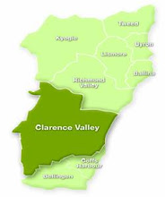
The DPI Combined Drought Indicator mapping currently indicates that in the seven Northern Rivers local government areas of north-east NSW at rough estimates:


Est. 7% of the Clarence Valley is In Drought, est. 57% is Drought Affected and 36% Non Drought;

Est. 8% of the Richmond Valley is In Drought, est. 72% is Drought Affected and 20% is Non Drought;

Est. 7% of Lismore is Drought Affected and 93% Non Drought;

Est. 21% of Kyogle is Drought Affected and 79% Non Drought;

Est. 56% of Tweed is Drought Affected and 44% Non Drought;

Est. 100% of Ballina is Non Drought; and

Est. 100% of Byron is Non Drought.


Rainfall deficiencies, Australia, December 2022 to June 2023:

Click on image to enlarge


In north-east New South Wales, an area of serious deficiency extends inland from the west of the ranges, with pockets of serious and severe deficiency east of the Divide and in the Hunter District. [Australian Bureau of Meteorology, 6 July 2023]


Monday 24 October 2022

MONDAY 24 October 2022: this morning in New South Wales


Australian Bureau of Meteorology (BOM), Current Warnings, Monday 24 October 2022


Note: The warning list was valid at 6.35am and is updated by BOM as circumstances changes


Thursday 15 September 2022

THREAT OF FLOOD REMAINS: a third La Niña event is underway in the Pacific Ocean and communities in eastern Australia should be prepared for above-average rainfall over spring and early summer


 Australian Bureau of Meteorology, media release, 13 September 2022:


La Nina event declared - above average rainfall likely for eastern Australia


The Bureau of Meteorology has declared a La Niña event is underway in the Pacific Ocean and communities in eastern Australia should be prepared for above-average rainfall over spring and early summer.


Bureau of Meteorology head of long-range forecasts, Dr Andrew Watkins, said the Bureau's three-month climate outlook shows a high chance of above average rainfall for most of the eastern half of the Australian mainland and eastern Tasmania.


During La Niña events, waters in the eastern tropical Pacific Ocean are cooler than normal, and waters in the western tropical Pacific Ocean warmer than normal. This causes changes in wind, cloud and pressure patterns over the Pacific. When this change in the atmosphere combines with changes in ocean temperature, it can influence global weather patterns and climate, including increasing rainfall over large parts of Australia”.


Dr Watkins said while La Niña criteria have been met, most models forecast this event to be weak to moderate in strength, likely to peak during spring and ease during summer.


"La Niña is not the only driver influencing this wet outlook. To our west, a significant negative Indian Ocean Dipole (IOD) event is underway. We expect the IOD influence will reduce in late spring or early summer,” Dr Watkins said.


"The Southern Annular Mode (SAM) is also in a positive phase, and likely to remain positive into summer. Positive SAM during summer pushes weather systems south, which increases the chance of rain in New South Wales, eastern Victoria and southern parts of Queensland,” he said.


Dr Watkins said all these climate influences push Australia's climate towards a wetter phase, and together have shaped our outlook for the coming months that shows more than 80 per cent chance of above average rainfall for many parts of the eastern half of Australia.


With catchments already wet, the flood risk remains, particularly for eastern Australia.


The Bureau is encouraging communities to keep up to date with the latest forecasts and warnings on the Bureau's website and BOM Weather app.


For more information about our climate outlook and La Niña visit our website:


2022 marks the third year in a row of La Niña conditions. 

 *

Thursday 18 August 2022

Still no assurances that increased heavy rainfall episodes in south east Australia have gone and 'normal' seasonal weather returned


Unfortunately it appears that north-east NSW can not yet rest easy.....


ABC News, 16 August 2022:


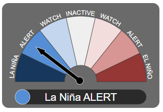
The odds of there being a third sodden summer in a row have shortened now the Bureau of Meteorology has declared a La Niña alert.


Renewed cooling in the tropical Pacific Ocean and models indicating La Niña is likely during spring and early summer have prompted the BOM to raise the El Niño Southern Oscillation Index scale to "alert", the last step before an official La Niña.


Four of seven climate models it surveys suggest La Niña could return by early to mid spring. The remaining three suggest levels will remain neutral but close to the La Niña threshold through to the end of 2022.


If the climate driver is declared, it would be the third consecutive La Niña summer.


Triple-dip La Niñas are relatively rare, having only occurred twice since 1950, in 1973-76 and 1998-2001.


But with catchments already primed and water storages full, the third wet year could signal disaster.


National water storage levels are currently sitting at 71.3 per cent, up 5 per cent on last year, while the Murray-Darling Basin is sitting at 92.2 per cent, up 12.4 per cent on this time last year.


Many dams up and down the east coast are now sitting at or over capacity….


With catchments sodden, it won't take much before the water has nowhere to go…..


This year the rainfall is being further charged by a negative Indian Ocean Dipole (IOD), which has already been declared.


Much like a La Niña, a negative IOD means there is extra moisture available, this time in the north-west.


Frontal systems can then tap into that moisture and drag it across the country, typically bringing wetter than average conditions for south-eastern Australia in winter and spring until the monsoon moves down and breaks up the cycle in early summer.


All La Niñas and IODs are different and there are no guarantees when it comes to forecasting.


But even if the Bureau's official La Niña thresholds are not met this summer, above average sea surface temperatures will likely aid rainfall.


At this point, there is a strong chance of a third La Niña, acting on already primed catchments, with a complementary IOD, which is likely to bring more rounds of flooding rains this spring and summer....


Insurance News, 16 August 2022:


Flood fears increase as likelihood of rare triple-dip La Nina rises


The Bureau of Meteorology has today issued a La Nina alert, meaning there’s now a 70% chance that the flood-inducing climate driver will develop this year.


It would be the third La Nina in a row – something that has only happened twice since 1950 – leading to fears of more heavy rain along the already flood-hit east coast of Australia.....


Australian Bureau of Meteorology, ENSO Outlook An alert system for the El Niño–Southern Oscillation, 16 August 2022:


ENSO Outlook moves to La Niña ALERT


The ENSO Outlook has [moved] to La Niña ALERT. This means that even though the El Niño–Southern Oscillation is currently neutral, the chance of La Niña forming in the coming months has increased to around 70%. This is roughly three times the normal likelihood of an event forming in any year.


This status change follows a renewal of cooling in the tropical Pacific Ocean towards La Niña thresholds over recent weeks, as well as the persistence of the Southern Oscillation Index (SOI) at La Niña levels and strengthened trade winds at La Niña levels. Climate models indicate further cooling is likely, with four of seven models suggesting La Niña could return by early-to-mid southern hemisphere spring.


A La Niña ALERT is not a guarantee that La Niña will occur, rather it is an indication that most of the typical precursors of an event are in place. La Niña conditions increase the chance of above average spring and summer rainfall in northern and eastern Australia.


Bureau climatologists will continue to closely monitor conditions in the tropical Pacific as well as model outlooks for further signs of La Niña re-emergence.


"The chance of a La Niña developing in the coming season has increased. When these criteria have been met in the past, a La Niña event has developed around 70% of the time.".....


La Niña Alert


Any three of the following criteria need to be satisfied:


  • Sea surface temperature: A clear cooling trend has been observed in the NINO3 or NINO3.4 regions of the Pacific Ocean during the past three to six months.

  • Winds: Trade winds have been stronger than average in the western or central equatorial Pacific Ocean during any two of the last three months.

  • SOI: The two-month average SOI is +7 or higher.

  • Models: A majority of surveyed climate models show sustained cooling to at least 0.8 °C below average in the NINO3 or NINO3.4 regions of the Pacific Ocean by the late winter or spring.


Thursday 26 May 2022

Communities in the seven local government areas of the NSW Northern Rivers region know where they have been in 2022 and now they know where they are heading - into more rain


ENSO Outlook
An alert system for the El Niño–Southern Oscillation, 24 May 2022


Australian Bureau of Meteorology:


Special Climate Statement 76 - Extreme rainfall and flooding in south-east Queensland and eastern New South Wales, February-March 2022

25/05/2022 - National


Issued at 10:30am, Wednesday 25 May 2022


The Bureau of Meteorology has released a formal record of the extreme rainfall and flooding that occurred in south-east Queensland and eastern New South Wales in February and March this year.


Special Climate Statement 76 outlines that several rainfall records were broken between 22 February and 9 March 2022, with more than 50 sites recording more than one metre of rainfall in one week.


In the last week of February, parts of south-east Queensland and north-east New South Wales had rainfall 2.5 times their monthly average with some regions recording more than five times their monthly average.


After two years of La Niña conditions, the rain fell on saturated catchments leading to flash and riverine flooding extending from Maryborough in Queensland to Grafton in New South Wales.


For many areas, this was the wettest week since at least 1900. Some areas of south-eastern Queensland had their highest flood peaks since 1893, though the lower Brisbane and Bremer rivers and Lockyer Creek peaked below the levels of both January 1974 and January 2011 floods.


In parts of northern New South Wales, flood levels broke previous records. Wilsons River in Lismore peaked at a record high level, estimated to be 14.4 m on 28 February. The previous record was 12.27 m in February 1954.


The rainfall was the result of a combination of weather systems over eastern Australia and the Tasman Sea, where a large volume of humid tropical air moving onshore over eastern Australia was lifted in the atmosphere to produce heavy rain and thunderstorms.


In recent decades, there has been a trend towards a greater proportion of high-intensity, short-duration rainfall events, especially across northern Australia.


The Bureau's special climate statements provide detailed summaries of significant weather and climate events that impact Australians. This Special Climate Statement has been added to an archive of Special Climate Statements dating back more than 15 years, providing easy access to data and information.


Special Climate Statement 76 can be found here: http://www.bom.gov.au/climate/current/statements


The Guardian, 25 May 2022:


The breakdown of the La Niña weather pattern in the Pacific has stalled while a key Indian Ocean climate driver is tilting towards its wetter phase, making it more likely that eastern Australia will face more heavy rain and floods.


Just as the Bureau of Meteorology released a special climate report on the extreme rainfall and flooding that hit parts of south-eastern Queensland, northern New South Wales and the region around Sydney in February and March, its fortnightly report on climate influences pointed to the big wet extending for months to come.


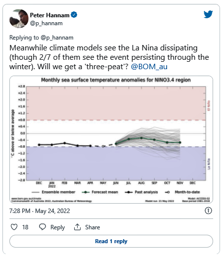
The La Niña event, already in its second year, could yet persist into a third. The expected dissipation of the pattern has not progressed in the past two weeks, and two of the seven models used by the bureau project that the La Niña will last through winter.


Out west, the Indian Ocean dipole is forecast by all climate models to enter its negative phase in coming months.


That phase of the dipole – which gauges the relative differences of sea-surface temperatures across the ocean – increases the chances of above-average winter-spring rainfall for much of Australia. It also lifts the odds of warmer days and nights for northern Australia, according to the bureau.


The prospect of wetter than normal conditions for the east coast in particular will prompt fears of further floods. Catchments remain damp and dams are full, so it won’t require significant bursts of rain to cause more flash flooding and damage.


Read the full article here.


Thursday 12 May 2022

Eight days out from the 21 May 2022 federal general election and much of the NSW Northern Rivers region is on flood watch again


Australian Bureau of Meteorology (BOM):

Flood Watch for the Northern Rivers and Central West

Issued at 12:21 pm EST on Thursday 12 May 2022


Flood Watch Number: 3


MINOR FLOODING POSSIBLE IN THE NORTHERN RIVERS AND CENTRAL WEST FROM THURSDAY


A trough over western inland New South Wales will generate further moderate to heavy rain in many areas of the Central West on Thursday. This may cause minor flooding along the Castlereagh, Macquarie and Bell Rivers from Thursday night.


* Reissue to include Castlereagh *


River level rises have been observed from recent moderate rainfall in the Northern Rivers. Further moderate showers expected on Thursday may see river levels rise to minor flood levels.


Renewed minor flooding is also possible along the Bogan River where a flood warning is current.


The Bureau is continuing to monitor the situation and will issue further catchment specific warnings if and when required.


Catchment soil moisture is average.


The weather system is expected to cause flooding for the catchments listed. Flood Classes (minor, moderate, major) are only defined for catchments where the Bureau provides a flood warning service.


Catchments likely to be affected include:


Tweed and Rouse Rivers - minor flooding 

Brunswick River and Marshalls Creek - minor flooding

Wilsons River - minor flooding

Richmond River - minor flooding

Castlereagh River - minor flooding

Orange, Molong and Bell River - minor flooding

Turon and Macquarie Rivers to Burrendong Dam - minor flooding

Macquarie River d/s Burrendong Dam - minor flooding


Flood warnings are current for the Culgoa, Bokhara, Bogan, Paroo and Warrego Rivers.


For the latest flood and weather warnings see www.bom.gov.au/nsw/warnings/


For the latest rainfall and weather forecasts see www.bom.gov.au/australia/meteye/


For the latest rainfall and river level information see www.bom.gov.au/nsw/flood

 [my yellow highlighting]

~~~~~~~~~~~~~~~~~~~~~~~~~~


There is a chance of above median rainfall across much of the continent from 14 May 2022 to September 2022.


According to BOM long range forecasting there is also a 50-60% chance of the Page and Richmond electorates in the Northern Rivers region being “unusually wet” between 14 to 27 May 2022.


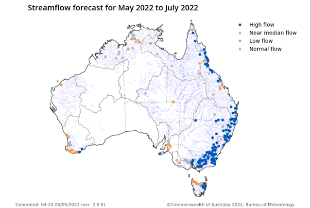
Stream Flow Forecast


Click on image to enlarge


Climate outlook overview

Issued: 5 May 2022


Winter (June to August) rainfall is likely to be above median for most of Australia, except south-western Australia, the south-east coast, and southern Tasmania which have roughly equal chances of being above or below median.

June to August maximum temperatures are likely to be above median for northern, south-western, and south-eastern parts of Australia, but below median for broad areas of inland southern and central Australia.

Minimum temperatures for June to August are very likely to be warmer than median across almost all of Australia.

The weakening La Niña, the chance of a negative Indian Ocean Dipole, and other localised drivers are likely to be influencing this outlook.


Latest Climate Driver Update, 10 May 2022:


La Niña maintains strength


The 2021–22 La Niña event continues in the tropical Pacific, with little change in strength in the past few weeks.


Several indicators of La Niña, including tropical Pacific sea surface temperatures, cloudiness near the Date Line, and the Southern Oscillation Index (SOI), have maintained or slightly increased their strength over the past fortnight. However, beneath the surface of the tropical Pacific, waters have warmed closer to neutral El Niño–Southern Oscillation (ENSO) levels.


Most climate models surveyed by the Bureau indicate a return to neutral ENSO by the early southern hemisphere winter. Only one of seven models continues La Niña conditions through the southern winter. La Niña conditions increase the chances of above average rainfall for much of eastern Australia, while neutral ENSO has little influence on rainfall patterns.


The Indian Ocean Dipole (IOD) is neutral. All climate model outlooks surveyed suggest a negative IOD may develop in the coming months. While model outlooks have low accuracy at this time of year and hence some caution should be taken with IOD outlooks beyond May, there is strong forecast consistency across international models. A negative IOD increases the chances of above average winter–spring rainfall for much of Australia. It also increases the chances of warmer days and nights for northern Australia.


The Southern Annular Mode (SAM) index is currently positive and is forecast to remain positive for the coming four weeks. During autumn SAM typically has a weaker influence on Australian rainfall, but as we approach winter, positive SAM often has a drying influence for parts of south-west and south-east Australia.


The Madden–Julian Oscillation (MJO) has recently strengthened in the western Indian Ocean. Most climate models indicate the MJO will briefly weaken, and then re-strengthen again later this week in the Maritime Continent or western Pacific region. Should the MJO re-strength in the Maritime Continent region, it can enhance rainfall in north-eastern Australia. It also typically increases cloudiness to Australia's north.


Climate change continues to influence Australian and global climate. Australia's climate has warmed by around 1.47 °C for the 1910–2020 period. Southern Australia has seen a reduction of 10–20% in cool season (April–October) rainfall in recent decades. There has also been a trend towards a greater proportion of rainfall from high intensity short duration rainfall events, especially across northern Australia. [my yellow highlighting]