Showing posts with label weather. Show all posts

Thursday 19 February 2015

Flow-on effects of Cyclone Marcia: NSW North Coast may be in for an interesting time


ABC News 18 February 2015 showing where the predicted big wet is coming from and where it is finally heading:


Australian Bureau of Meteorology:

Severe Weather Warning for heavy rainfall for people in the Northern Rivers, Mid North Coast and Northern Tablelands forecast districts
Issued at 4:12 pm EDT on Thursday 19 February 2015.
HEAVY RAIN FOR NORTHEAST NSW ON FRIDAY
Weather Situation
A trough associated with Tropical Cyclone Marcia to the north is expected to deepen over northeastern New South Wales later Thursday and Friday bringing heavy rain.
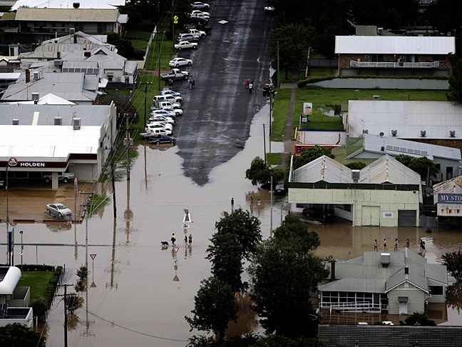
Rain which may lead to FLASH FLOODING is forecast for the Northern Rivers forecast district, in addition to northern parts of the Mid North Coast and eastern parts of the Northern Tablelands forecast districts during Friday.
At the time of issue a Flood Watch was current for the NSW coast from the Queensland border to the Nambucca Valley for Friday and Saturday.
The State Emergency Service advises that people should:
·         Don't drive, ride or walk through flood water.
·         Keep clear of creeks and storm drains.
·         If you are trapped by flash flooding, seek refuge in the highest available place and ring 000 if you need rescue.
For emergency help in floods and storms, ring your local SES Unit on 132 500.
The next warning will be issued by 11:00 pm EDT Thursday.
This warning is also available through TV and Radio broadcasts; the Bureau's website at www.bom.gov.au or call 1300 659 218.
The Bureau and State Emergency Service would appreciate this warning being broadcast regularly.

Thursday 19 June 2014

Watching the weather with bated breath......


Photograph: Queensland Country Life 24 January 2014


The world’s meteorologists and climate experts are watching closely for another burst of westerly winds across the Pacific that could trigger the first El Nino weather pattern since 2009-2010.

“Basically it is primed for a strong El Nino, but it needs the final push,” said Axel Timmermann, the professor of oceanography at the international Pacific research centre, University of Hawaii. “This is perhaps the most-watched El Nino of all time.”

The weather watch comes as winter remains largely at bay for much of Australia. Sydney and Melbourne broke heat records during autumn and maximums in both cities have been about 2-3 degrees above average for June.

This week, Sydney can expect tops most days of 20-22 degrees, or about 3-5 degrees above normal, while Melbourne's maximums will be 1-2 degrees above the June average of 14 degrees, the Bureau of Meteorology said.

An El Nino could make this year another warm one for Australia. Last year was the country's warmest in more than a century of records.

El Ninos form when waters in the eastern Pacific turn unusually warm compared with the west, stalling or reversing the easterly trade winds. The pattern is a major driver of the world’s climate and can trigger droughts and bushfires in Australia and east Asia, while bringing heavy rains to countries bordering the eastern Pacific……

National Climate Centre Drought Statement 4 June 2014

Saturday 18 January 2014

Below average rainfall likely across Northern Rivers region January-March 2014


December catchment conditions


December rainfall was below to very much below average for most of Queensland and New South Wales. Parts of southwestern New South Wales and northern Victoria recorded above average December rainfall. The Murray-Darling Basin recorded only 21.3 mm of rain, the driest December since 2001. More information about December weather and climate conditions can be found in the climate summaries for Victoria, New South Wales, Queensland and Northern Territory.
Near median December streamflows were recorded at 23 of the 69 locations and low streamflows at 45 locations. High December streamflow was recorded only at Swanfels, located in the Condamine-Culgoa basin in southern Queensland.

Streamflow forecasts for January to March


Near median and low streamflows for the January to March forecast period are more likely at 25 and 18 locations respectively. High flows are forecast to be more likely only at Rocks Crossing, located in the Manning basin in northern New South Wales. The forecast is not issued due to very low skill scores or missing streamflow data at 25 locations mainly in Queensland, Northern Territory and New South Wales.
The tropical Pacific has remained neutral with respect to the El Niño-Southern Oscillation (ENSO) since mid-2012, with all the main ENSO indicators remaining well within neutral bounds. International climate models surveyed by the Bureau of Meteorology indicate the persistence of this neutral ENSO phase through at least the austral autumn. The Indian Ocean Dipole (IOD) is currently neutral. It typically does not influence the Australian climate from December to April.
The chances of exceeding median rainfall during the January to March period are 30 to 40% over most of Queensland, parts of the eastern Northern Territory, most of New South Wales and northeastern Victoria. In other words, the chances of below average rainfall are 60 to 70% over these areas. Conversely, the chance of exceeding median rainfall is greater than 60% over parts of western Western Australia and most of Tasmania. The chance of receiving a wetter or drier than normal January to March period is roughly equal (i.e., close to 50%) over the remainder of the country.

Saturday 4 January 2014

Australian Bureau of Meteorology's Climate Statement 2013


No matter how hard the Australian Prime Minister and Liberal-National Coalition MPs in the Abbott Government attempt to minimise the effects of climate change or deny outright the reality of global warming, the facts are increasingly evident.


Wednesday 9 January 2013

Australian National Heatwave 9 January 2013


Australian Bureau of Meteorology Northern Rivers forecast for Wednesday 9 January:

Sunny morning. The chance of showers and thunderstorms from midday, with little, if any, rain reaching the ground. Winds north to northwesterly 25 to 35 km/h tending northwesterly in the middle of the day then shifting south to southeasterly in the afternoon. Overnight temperatures falling to the low to mid 20s with daytime temperatures reaching 37 to 42.
Fire Danger - Far North Coast: Severe
UV Alert from 8:50 am to 5:00 pm, UV Index predicted to reach 13 [Extreme]

Thursday 26 July 2012

Gone to sea


Years ago the NSW Government was told that climate change effects would mean that many of the state’s beaches would disappear over time.
This is Yamba’s main beach in the winter courtesy of The Daily Examiner online. Notice the absence of any hint of sand at high tide.

Sadly at low tide the beach is a pale ghost of its former self as Coastalwatch's live SurfCam shows.
This is a foolish Clarence Valley Council trying to defy the might of the sea and changed ocean conditions:
 
Erosion at Turner's Beach, Yamba
Pic from The Daily Examiner
UPDATE:
In a 17th July 2012 media release Clarence Valley Council and Mayor Richie Willamson forget what the Federal Government, NSW Government and CSIRO have been telling them for at least the last five years about expected erosion of soft shorelines in the lower Clarence River estuary*:
Whiting Beach in the Clarence River estuary
* Thanks to Clarencegirl for reminding me that some of these reports specifically address issues in the Clarence River estuary. 

Thursday 29 March 2012

April to June 2012 may be good weather for ducks in the NSW Northern Rivers region


National Seasonal Rainfall Outlook: probabilities for April to June 2012, issued 21st March 2012 by the Australian Bureau of Meteorology.

Wetter season favoured for much of eastern Australia

The national outlook for April to June 2012 shows the following:
  large parts of eastern Australia more likely to have a wetter season
  southeast SA, western and central Victoria, and Tasmania more likely to have a drier season
This outlook is mostly due to warmer than normal waters over the Indian Ocean.
The chances of receiving above median rainfall for April to June are above 60% over south eastern Queensland and the north eastern half of NSW, rising to a greater than 75% chance over the far northeast of NSW and southeast of Queensland. Such odds mean that for every ten years with similar ocean patterns like the current, about six to eight years would be expected to be wetter than average over these areas, while about two to four years would be expected to be drier during the April to June period…….

Thursday 8 March 2012

Rain, rain, go away - Autumn begins on the NSW North Coast


Weatherzone’s calendar for March 2012 and the beginning of Autumn on the NSW North Coast.


Friday 24 February 2012

Rainy day thoughts


This year on the farm started with rain which then developed into a downpour with intermingled showers. We were certain there was more rain on the way when the geese broke into the machine shed and set up camp out of the weather. This came as a surprise for of all the animals on the property they should have enjoyed the wet.

The road into the property became impassable - which meant that we were isolated for days at a time, the electricity was not that reliable and the telephone developed the tin tank echo it always has when the ground is soaked. At least this time the telephone did not have the sinister bomb tick it usually has when the neighbours electric fence shorts out.

It was very calm watching the water rise, fall and then rise again. This time was spent in comfort and thought. Friends and relatives rang up with concerned voices which started me thinking how long a city could survive with the same services that we in the rural areas receive.

It is not that I'm upset about the services (though there could be improvement) what was a worry was the thought of how a major flood incident in a city would affect the residents. How many have an evacuation plan? Do they know the choke points on the roads, what to take with them, what is needed to survive for an extended period if you stay put? How long could it be before help would arrive?

Photograph found at Clarence River Floods

Sunday 5 February 2012

Australian east coast flooding in pictures, January-February 2012


From Queensland through to News South Wales and Victoria -  La Niña flood waters were a problem to overcome.

Snapshots of Mitchell, Wee Waa, Moree, Belligen, Canungra Creek, Charleville, Coffs Harbour, Charlton and Lawrence........................


Photographs from ABC News files, SBS News, The Australian, The Age, and Goggle Images.

Sunday 25 September 2011

Faark, she's back!


La Niña conditions have returned and will continue into 2012 according to NOAA. Will there be widespread flooding for Christmas this year? Has anyone warned Santa that he might need a flood boat for Northern NSW and Queensland deliveries?


NOAA La Nina Advisory

Monday 13 June 2011

Severe weather warning for Northern NSW 13 June 2011


Australian Bureau of Meteorology

Issued at 4:25 am EST on Monday 13 June 2011.

Weather Situation

A strong high pressure system west of Tasmania is moving very slowly east extending a ridge across southeastern and northwestern New South Wales and a low pressure trough is deepening off the central and northern coasts.

Heavy rain which may lead to flash flooding is forecast for the Northern Rivers, Mid North Coast and the east of the Northern Tablelands forecast districts during today.

Between 9am yesterday morning and 4am this morning, Evans Head received 160 mm of rain, Yamba 126 mm, Coffs Harbour 94 mm and Kempsey 76 mm.

The State Emergency Service advises that people should:

*       Don't drive, ride or walk through flood water.

*       Keep clear of creeks and storm drains.


For emergency help in floods and storms, ring your local SES Unit on 132 500.

The next warning will be issued by 11:00 am EST Monday.

*       Flood Watch – Tweed, Richmond, Wilsons, Brunswick, Clarence, Coffs Harbour, Bellingen, Nambucca, Macleay, Hastings, Camden Haven, Manning and Macintyre regions.

*       Flood Warning - Bellinger River,  

*       Flood Warning - Orara River,

Tuesday 24 May 2011

Monster Twister Hits Joplin, Missouri, May 2011 (video)


Hardly a building was left standing in Joplin, 240km south of Kansas City after the tornado, reported to be 1.5km wide, hit late in the afternoon.

"I would say 75 per cent of the town is virtually gone," Kathy Dennis of the American Red Cross told CNN.

By nightfall local time, the death toll had risen to 24 and was expected to climb further.

The worst-hit building was the multi-storey St John's Hospital, where TV images showed nearly every window to be blown out. There were reports that debris from the building had been found 75km away, and local television reported fires throughout the building amid fears that broken gas lines in the hospital could cause an explosion.

The tornado was part of a series of severe weather patterns that hit the midwest, including in Minneapolis where a twister was blamed for the death of a 59-year-old man. A number of others were injured after tornadoes hit parts of Minnesota.

But Joplin and its population of 174,000 took a "direct hit" according to National Weather Service meteorologist Mike Griffin. "It went right through the centre of town," he told the Springfield News-Leader.

A man living almost 75km away from the hospital said that debris from the building, including medical supplies and X-rays, was found in his yard.

Jeff Lehr, a reporter for the Joplin Globe, was upstairs in his home when the storm hit but was able to make his way to a basement closet. "There was a loud huffing noise, my windows started popping. I had to get downstairs, glass was flying. I opened a closet and pulled myself into it," he said.

"Then you could hear everything go. It tore the roof off my house, everybody's house. I came outside and there was nothing left. There were people wandering the streets, all mud-covered.

"I'm talking to them, asking if they knew where their family is. Some of them didn't know, and weren't sure where they were."

The tornado struck less than a month after another tornado outbreak left 354 dead across seven US states.

[The Australian, Tornado 1.5km wide kills 24 in US midwest, 24 May 2011]


Images found at National Geographic and The Australian

Friday 29 April 2011

Rain, rain, go away. Come again another day.

With parts of the NSW North Coast exceeding average April rainfall before the month was out and the ground starting to sour in low spots, it's certainly been a soggy Autumn for many and it doesn’t look any better for May through to the end of July.


Bureau of Meteorology mapping

“The chances of receiving above median rainfall during the May to July period are between 60 and 75% over north eastern New South Wales and the southern half of Queensland, with the strongest odds on the Queensland/New South Wales border region (see map). Such odds mean that for every ten years with similar ocean patterns to those currently observed, about six to eight May to July periods would be expected to be wetter than average over these areas, while about two to four would be drier.”