Showing posts sorted by relevance for query dam. Sort by date Show all posts

Sunday 24 July 2022

Coming to grips with the reality of Clarrie Hall Dam in 2022 - Tweed Shire Council seeking community feedback on its draft water release strategy


Tweed Shire Council, media release, 21 July 2022:


Feedback invited on draft Clarrie Hall Dam Water Release Policy

Learn more about how water is released from Clarrie Hall Dam


Clarrie Hall Dam is the Tweed's main water storage facility. Council is seeking community feedback on its draft Water Release Policy, with an information session to be held in Murwillumbah on 10 August.


Tweed Shire Council has drafted a new policy to clarify and formalise Council’s operational practices in relation to water releases from Clarrie Hall Dam.


The Tweed’s main water supply is the Tweed River. Opened in 1983, Clarrie Hall Dam is located on Doon Doon Creek approximately 15 km south-west of Murwillumbah. The dam has a catchment area of 60 km² and holds up to 16,000 megalitres of water. Releases from the dam help keep the Tweed River flowing when water levels are low.


Clarrie Hall Dam was designed for the purposes of water storage for water supply only and it has an uncontrolled spillway. As such, Council cannot regulate or change the flow of water through the spillway, change the Full Supply Level (FSL) of the spillway, or maintain a surcharge above the spillway level.


Council’s Manager Water and Waste Water Operations Brie Jowett said the draft policy aims to explain Council’s operational practices when it comes to water releases from Clarrie Hall Dam.


Due to its design and purpose, Clarrie Hall Dam cannot be operated to release water ahead of rainfall events to provide any form of storage capacity for flood mitigation purposes,” Mrs Jowett said.


We know there is some misinformation within the community about water releases for flood mitigation and during floods at Clarrie Hall Dam and we want to clear that up.


We’ve put the draft policy on exhibition as we want to hear from all Tweed residents – especially those in flood–prone, downstream communities including Uki, Murwillumbah, Condong, Tumbulgum and Chinderah – to make sure they have all the information they need to understand how Council’s water release operations work.


It’s important our community understands that it’s not possible to use the dam for flood mitigation. There is no capability to regulate or change the flow of water through the dam’s spillway, nor change the full supply level of the spillway.


We are encouraging everyone to learn more about the dam’s design and how it is operated by reading the policy and let us know how to improve the policy to make it clearer.”


During a flood event, Council continuously monitors the safety of Clarrie Hall Dam and provides information to relevant authorities as per Council’s Dam Safety Emergency Plan.


You can review the draft and share your feedback by completing the online survey or attend the community information session on Wednesday 10 August at Murwillumbah Services Club from 4.30 pm. Registration is essential. For more details and to register visit yoursaytweed.com.au.


Submissions close on 16 August 2022.


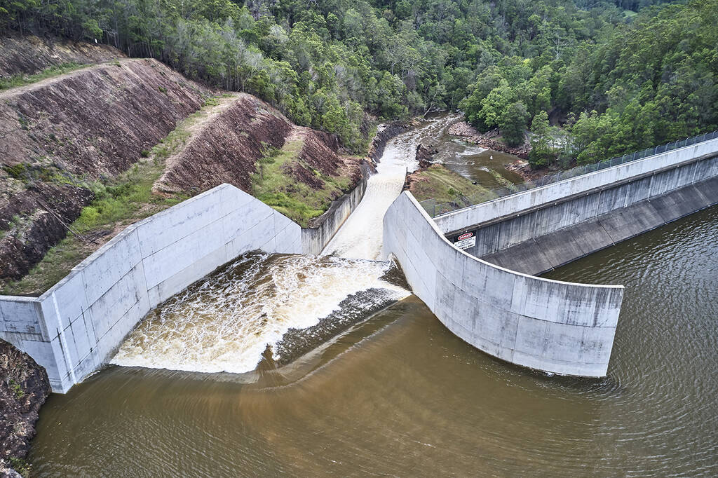
The spillway at Clarrie Hall Dam does not allow for flood mitigation as there is no capability to regulate or change the flow of water through the dam's spillway.


Friday 1 March 2013

Ibbotson's proposal to dam the Clarence River fails to impress


From A Clarence Valley Protest 28 February 2013:
 
Hot on the heels of an unforgivably uninformed suggestion from NSW Governor Marie Bashir that Clarence River catchment freshwater be diverted into the Darling River system, the Northern Rivers now has this latest attempt to revive the dam debate.

Page One of the Ibbotson advertisement
Click on image to enlarge

On 22 February 2013 The Daily Examiner ran a four-page advertisement by former Murray-Darling Basin resident, self-styled Scientist (metallurgy & computing) - who also happens to be a US Heartland Institute endorsed climate change denying, enthusiastic supporter of damming and diverting the Clarence River to inland NSW – John Ibbotson of Gulmarrad.

Mr. Ibbotson has obviously decided that media reports of Australian Opposition Leader Tony Abbott’s ‘100 Dams’ draft document (which includes the Clarence and Mann rivers) gives him the opportunity to push his own dam plan once more.

This time the self-named Ibbo’s Dam still includes a hydro-electric scheme as part of the dam infrastructure, but is without the option to divert water into the Murray-Darling river systems.

However, Ibbotson happily suggests that placing a throttle on the flow regime of three major rivers (Clarence, Mann and Nymboida) by placing a dam at the top of the Clarence River Gorge (thereby also effectively destroying this gorge), permanently flooding the lower reaches of the Mann River, potentially compromising the last known wild population of Eastern (Freshwater) Cod, changing the water temperature in a section of the river below the proposed dam/hydro scheme, reducing annual inflows into the lower river and reducing the frequency of ‘freshes’ reaching the estuary (relied on by a local commercial fishing industry worth an estimated $92 million annually) are great ideas.

In this advertisement he fails to consider the impact his hydroelectric scheme would have on Essential Energy's existing hydroelectric plant on the Nymboida River or on existing tourism and farming businesses in the areas his scheme intends to flood.

Additionally, he entirely fails to explain how such a dam would help mitigate Clarence Valley flooding beyond wishfully asserting that it will.

This is a mock-up of a Clarence River dam posted on A Clarence Valley Protest in 2007:


This is the Clarence River Gorge in 2011:


And here are letters to the editor published in The Daily Examiner on 25 and 27 February 2013:

Ads are 'light relief'
On 18 September 2012 I had a letter to the editor published in The Daily Examiner on the subject of a "specific call to dam and divert water from the Clarence River catchment area" and "general calls to harvest water from east coast rivers for use in the Murray Darling Basin" in submissions before the NSW Legislative Council Standing Committee on State Development's Inquiry Into The Adequacy Of Water Storages in NSW.
On February 22, 2013 I was amused to find this letter selectively quoted in an expensive four-page advertisement created by that ardent climate change denier and supporter of damming and diverting freshwater from the Clarence River catchment into the Murray-Darling Basin, John Ibbotson (Senate Standing Committee of Regional Australia, Water Proofing the Murray-Darling Basin, Submission No. 158, dated received 7 December 2010).
I chortled when I discovered Mr Ibbotson obviously believed that I read transcripts with my ears and was impressed by the contortions involved in trying to make it appear that my letter ignored the subject of inter-basin water transfer.
I thank Mr Ibbotson for pointing out to Clarence Valley residents that the O'Farrell Government has no policy to protect the Clarence River from being dammed, even if at the inquiry's 20 August 2012 hearing it was demonstrated that David Harriss of the NSW Office of Water was not in favour of building expensive new dams:
"The Hon. Dr Peter Phelps: Is there any need for new dam building or simply perhaps raising storage capacities of the existing catchments?
Mr Harriss: I think the issues we have tried to raise in our submission are the billions of dollars invested in major infrastructure now, with both public infrastructure and on-farm infrastructure. I think (the) priority (for) New South Wales is to use that infrastructure as effectively and efficiently as possible in the first instance rather than investing further in up to millions of dollars in capital expenditure."
In the middle of all that wind and rain, Mr Ibbotson offered some welcome light relief and I'll gratefully use his advertisement to wrap my kitchen scraps later today.
JUDITH M. MELVILLE
Yamba

No need for stirring
I am writing in response to John Ibbotson's 4 page "story" in the Examiner (22/02/13). I replied directly to his email (provided in the story), expressing my concern that his story was lacking figures of the dam capacity and flood flows to demonstrate how much a major flood could be minimised. I also expressed my environmental concerns.
John replied with, "I find that facts and figures in an article tend to result in people's eyes glazing over. This story was meant to be more of an emotive story..."
When reading his story, I found my own eyes "glazing over", as the "emotive" often tended to overshadow the substance. This issue has often been an emotional one, with people on both sides having strong opinions without many facts. The last thing it needs is another "emotional stirring" to cause people to feel they must be either for or against a dam. The issue needs an objective presentation of clear factual data addressing public concerns.
My concerns include the effects of the cold water releases on the ecosystem of the river below the dam, and all the way to the ocean.
John addressed environmental concerns in his story with "But it would ruin the river! I doubt it". Then he was sidetracked discussing Alaska and barbed wire.
With the help of Landcare, I had a flora and fauna survey conducted on our property (just below the Gorge), which demonstrated a diverse range of species including endangered and threatened species. John included a photo of one of our young cows with her vealer heifer calf in his story. He sarcastically referred to them as "rare native cowroos", attempting (I think?) to devalue the importance of the native wildlife, or to prove that the presence of cattle dramatically reduces the environmental value of the area?
Another concern is how a hydro-electric dam and a flood mitigation dam can operate at this site without being in conflict with each other. As locals know, we also have "dry periods'' where rain events contribute little to the river system. Electricity generation would require contracts to guarantee supply to the grid, and therefore need a minimum level in the dam to ensure this (and allow for dry weather). Calculations need to be made to show a flood event would not simply top the dam and flood anyway, like Wivenhoe dam did in 2011 in Brisbane. A dam could also turn floods into longer drawn out events, possibly impacting on lower areas (including Yamba) and beaches for longer. My great grandfather, Sir Earle Page, had detailed plans drawn up for a "Clarence river hydro-electric scheme" in the 1940s, but it calculated that many dams were needed to manage the flows and to guarantee supply.
ROBERT PAGE
"Heifer Station"
 

Thursday 17 October 2019

The real reasons behind the push to dam and divert water from the Clarence River catchment


Whenever local government areas within the Murray-Darling Basin decide to renew their almost perpetual lobbying of federal and state governments for consent to dam and divert one or more rivers within the Clarence River catchment they usually have a hidden agenda accompanying their public call for fresh water for inland towns during times of water scarcity.
It has never been about needing water for towns which might run out of water by late 2020. Any new dam couldn’t even be ‘shovel ready’ in less than two to three years, while rushing construction would take a similar time period to complete and filling a dam would take more than three years on top of that – if it could be achieved at all in an Australian climate which has been drying for the last sixty years.
What these councils are really seeking is the means to grow their own local businesses and expand their own regional economies at the expense of Clarence Valley and Coffs Harbour City current and future businesses and regional economies.
One of the mayors openly states that “water is the new currency” - echoing that other sentiment doing the rounds, ‘water is the new gold’.
Take these latest water raiding schemes……….
1. MARYLAND RIVER DAM AND DIVERSION SCHEME FOR THE BENEFIT OF ONE NSW AND THREE QLD LOCAL GOVERNMENT AREAS
According to Daily News in Warwick Qld, Southern Downs Council has a wish list for growth; Councillor Marika McNichol said the council had a wish list of significant infrastructure projects that would shape, steer and secure the region’s future.“This is an ambitious list of projects, but also a list of essential infrastructure projects that will benefit our region and build a sustainable future for the Southern Downs,” Cr McNichol said.“Council has a strong long-term vision for the region which involves major infrastructure projects.”
On its own website this council stated; “Southern Downs Regional Mayor, Tracy Dobie said a number of exciting projects in the Southern Downs were due to commence or be completed, creating employment opportunities, encouraging population growth and stimulating strong economic activity,”
One of those proposed major infrastructure projects to allow economic expansion in this particular local government areas is a “Pipeline diversion of water from the Clarence River in NSW to Tenterfield, Southern Downs, Western Downs and Toowoomba”. This proposal is being submitted to Infrastruture Australia seeking funding to progress the interbasin-interstate water transfer scheme.

Access to water is seen as a key economic driver by Western Downs Regional Council. This includes being a driver of industry and business development as well as optimising tourism growth in the local government area.

Toowoomba Regional Council Mayor Paul Antonio told a journalist that; water is the limiting factor in population growth and food production in this area”. His letter of support for the application to Infrastructure Australia for a dam in the Clarence River catchment reads in part; As chair of Darling Downs South West Queensland Council of Mayors … I write to give the strongest of support to your council’s submission to the Australian Infrastructure Audit regarding long-term water security on the Darling Downs and NSW Border Ranges.”

Tenterfield Shire Council’s mayor told The Daily Examiner in Grafton NSW; “I have no problem supporting populations to support industry, but you cannot do it without infrastructure to secure water. These towns need to be supported, and especially where they are looking to expand. (Towns like) Warwick and Toowoomba should have had adequate water supply years ago and now we are playing catch up.” [my yellow highlighting]

Tenterfield Shire Council as part of the Northern New England High Country Regional Economic Development Strategy 2018-2022 supports the position that; “There is potential to dam both the Mole River in the western part of the Region and possibly one or more of the headwater tributaries of the Clarence River for irrigation water and the generation of hydroelectricity.”

Tenterfield’s Mole River proposal was tentatively costed sometime in the 1990s on the basis that private capital would build this dam and lease it back to either local or state government. The current proposal for a Mole River dam (20-40 per cent smaller than the original proposed water storage) is an initial 50/50 split between state and federal government.

2. ABERFOYLE RIVER DAM AND DIVERSION SCHEME TO BENEFIT GWYDIR SHIRE COUNCIL, GWYDIR RIVER AND COPETON DAM, NSW

The NSW Berejiklian Coalition Government’s State Infrastructure Strategy 2018-2038 points to a need to Identify investment options in the priority catchments of Gwydir and Macquarie”.

Gwydir Shire Council in its Gwydir Shire Economic Development Strategy 2017-2020 states an aim to; Manage water resources for a growing economy and environmental sustainability” as well as to improve/expand the Shire’s product base which includes the tourism potential of the Gwydir River and Copeton Dam.

The river and dam are seen as part of providing a Strong basis for growing the tourism sector and building visitation to the Shire’s towns and villages” - as well as being seen as “lifestyle advantages of the Shire.”

The development strategy also sees “access to plentiful water” as a prerequisite to growing local businesses and establishing new ones.

Seeing water as a mere commodity these Murray-Darling Basin councils and the federal government are pressuring the NSW Berejiklian Coalition Government to such a degree that it is now considering altering planning and water legislation to allow NSW Water to have planning control over dam building and also allowing environmental safeguards to be overridden – in particular removing environmental/biodiversity assessments of proposed dam sites and potentially commencing construction before a cost-benefit analysis has been completed.

Tuesday 1 June 2021

With Australian PM & Liberal MP Scott Morrison and the tail wagging the NSW Government dog, Deputy Premier & Nationals MLA John Barilaro, both backing the proposed Mole River dam it appears that yet another poorly conceived and badly placed dam will be built


Dam valley: The Mole River looking upstream from Ringtree and Braeside' to Alister, where more than 800 ha of productive land and native vegetation is proposed to be flooded by the dam.
Photo: Bruce Norris in Tenterfield Star


On 12 August 2020 the NSW Legislative Council Portfolio Committee No. 7 – Planning And Environment self-referred the Inquiry into the rationale for, and impacts of, new dams and other water infrastructure in NSW.


This inquiry looked into the rationale for, and impacts of, new dam and mass water storage projects proposed by Water NSW including Wyangala, Mole River and Dungowan Dam projects, the Macquarie River reregulating storage project, the Menindee Lakes Water Savings Project and the Western Weirs project.


Water NSW undertook a feasibility study of the Mole River in 2017 which stated that none of the dam proposals for this river were financially viable at the time.


In 2019 the Morrison Government gave its support for a 100,000 megalitre Mole River dam which it saw as not just supplying Tenterfireld Shire with water but also sending water to south-east Queensland.


This begs the question of where the bulk of the water would be coming from given the Mole River catchment annual rainfall was less than 600mm in 13 of the last 18 years (2019) and, as Professor Quentin Grafton, water economist, ANU and UNESCO Chair in Water Economics and Transboundary Water Governance tells us, at 600mm or less annual precipitation a dam will not fill.


Tenterfield Shire Council has long made it clear that it sees a potential relationship between a Mole River dam and water from the Clarence River catchment - viewing interbasin water transfer from Upper Clarence River tributaries (in particular the Maryland River) to the proposed dam site as desirable additional water storage which would allow for water diversion into the border rivers system for the benefit of Murray Darling Basin irrigators and/or the establishment of a hydro electric scheme with the shire.


Northern Rivers readers might also recall that the Mole River has a long history of arsenic contamination.


ResearchGate, December 2001:


Mining and processing of arsenopyrite ore at the Mole River mine in the 1920–1930s resulted in abandoned mine workings, waste dumps and an arsenic oxide treatment plant. Weathering of waste material (2.6–26.6 wt% As) leads to the formation of water soluble, As-bearing mineral salts (pharmacolite, arsenolite, krautite) and sulfates which affect surface waters after rainfall events. Highly contaminated soils, covering about 12 ha at the mine, have extreme As (mean 0.93 wt%) and elevated Fe, Ag, Cu, Pb, Sb and Zn values compared with background soils (mean 8 ppm As). Regionally contaminated soils have a mean As content of 55 ppm and the contaminated area is estimated to be 60 km2. The soils have acquired their metal enrichments by hydromorphic dispersion from the dissolution of As-rich particulates, erosion of As-rich particulates from the dumps, and atmospheric fall-out from processing plant emissions. Stream sediments within a radius of 2 km of the mine display metal enrichments (62 ppm to 27.5 wt% As) compared with the mean background of 23 ppm As. This enrichment has been caused by erosion and collapse of waste-dump material into local creeks, seepages and ephemeral surface runoff, and erosion and transportation of contaminated soil into the local drainage system. Water samples from a mine shaft and waste-dump seepages have the lowest pH (4.1) and highest As values (up to 13.9 mg/L), and contain algal blooms of Klebsormidium sp. The variable flow regime of the Mole River causes dilution of As-rich drainage waters to background values (mean 0.0086 mg/L As) within 2.5 km downstream. Bioaccumulation of As and phytotoxicity to lower plants has been observed in the mine area….


By the time the current Mole River Dam scoping report had been completed the Mole River Dam project had been declared Critical State Significant Infrastructure (CSSI) under Division 5.2 of the NSW Environmental Planning and Assessment Act 1979 (EP&A Act).


As a CSSI the project may be carried out without obtaining development consent under Part 4 of the EP&A Act.


Friday 12 April 2013

Leaving the Clarence River dam-less


Letter to the Editor The Daily Examiner 25 March 2013:

Leave river dam-less

I ADMIRE Mr Ibbotson for having the conviction and resources to restart the debate concerning dams on the Clarence in such a bold way. I learnt some things from his interesting opinion piece, but feel I must correct a number of points and state some facts that have been omitted.
Most of us here in the Lower Clarence floodplain live below the 10m contour and are at the mercy of floods - the price we pay for the benefits I guess. No doubt a structure could be built on the Clarence that would mitigate the impacts of some floods, but not without irreversible consequences. Despite whether Ibbo's dam could stop the floods we experienced this year or not, there are a number of ecological considerations that were not covered in his advert. These relate not only to his dam but any dam proposed for the Clarence.
What he and his supporters fail to appreciate is the Clarence River is a sum of its whole. The Clarence River needs floods. From its headwaters to the mouth it is one functioning ecosystem that has provided and will continue to provide directly and indirectly to the livelihoods and wellbeing of generations of floodplain farmers, fishers and communities of the Clarence Valley. The still functioning Clarence brings essential nutrients, carbon and sediment to the lower river, the estuary, the floodplain and the ocean from upstream.
It does this mostly in times of flood. With a dam we irreversibly cut this flow and impact on the function of the whole river system and its floodplains, both upstream and downstream. Flooding is an essential process of our still-functioning river.
Mr Ibbotson states that his dam will create a "pleasant lake". A look at a topographical map shows that this will be a very large "pleasant lake". About 65km in length if the 80m contour is flooded and over 100km if the 100m contour is flooded. A 100km artificial lake to replace 100km of natural functioning river habitat, home to local fish species found in numbers not known anywhere else in the world. Local fish such as the endangered eastern freshwater cod, bass, eel-tailed catfish, freshwater herring, eels and mullet along with platypus, birds and water plants are all dependant upon on this section of the river and access through it.
The fish are mostly migratory species and are dependent on the natural freshes and floods to move between spawning and breeding and feeding grounds along the length of the river from the estuary to around 800m elevation.
Mr Ibbotson's assertion that "lakes are great" because they attract more wildlife diversity, people and achieve environmental outcomes is difficult to support in the case of his dam.
To raise water levels to the 80m contour a dam of 30m height would be required. To dam to the 100m contour a dam 50m high would be required. The Clarence river gorge, located approximately 150km upstream of the Clarence River mouth, has seven waterfalls of between two and 8m in height and is a natural barrier to these migratory fish on their long (up to 300km) return trips from the estuary. The Clarence Fishtrack study has shown that Australian bass are only able to pass upstream of these falls during flood events that occur on average every 1.25 years when the falls are drowned out.
The legacy of inappropriate land use and clearing in the upper catchments, particularly the Timbarra catchment has provided a huge amount of sediment into the Upper Clarence which is now making its way downstream.
Unfortunately the volumes are so large upstream of the gorge that they are likely to pose a limit on the capacity of Ibbo's dam over time. This sediment, while damaging to our river's deep waterholes, is vital to replenish that which is washed out to sea. If it is trapped behind Ibbo's dam then we could expect increased erosion downstream.
Mr Ibbotson's claim that the tidal section "belongs to the sea" is false. It is simply the tidal portion of the Clarence River, a connected part of the Clarence River ecosystem accessed by some marine and estuary species moving upstream including sharks and dolphins who come up to feed, and freshwater species such as bass, mullet and eels which migrate downstream at times in their life cycle.
To function as the healthy productive estuary that it is, our river relies almost entirely on inputs from upstream. The replenishment of silt, sediment, nutrients and organic carbon and of course fresh water all comes from upstream, most of which would be trapped behind Ibbo's dam and therefore denied to the estuary, floodplain, wetlands, farms, soils, in-stream plants and animals that depend upon this input to replenish that washed out to sea naturally as part of the functioning river.
I hope Mr Ibbotson, after living in our Valley for a bit longer, will grow to appreciate the wonder of the east coast's most pristine large river system. He could use his creative skills and resources to promote a greater understanding of its ecology, its unique species and habitat and its existing tourism opportunities.
The advert points out accurately that the river is stressed through many human interventions. But despite this, it still supports NSW's largest fishing fleet, a viable cane industry, internationally recognised wetlands, a vast diversity of threatened species and a community which is proud of its river.
No other NSW river still does this like the Clarence, but they all used to. The main reason we are lucky enough to live alongside one of the last healthy large river systems in Australia is simply because it has been allowed to run free, to flood and to function as a river should - without dams.

Nigel Blake
Grafton

Sunday 27 February 2011

Clarence Valley's 'professional' contrarians are at it again


Mighty Clarence
Ed,
Over the years there has been a resistance to building a dam on the Clarence River – “Not One Drop – The Mighty Clarence”. This seems to be irrational and a case of NFromMBY. It’s not as though we use very much of the water. According to government figures < 1% of the water is being used with the other 99% going out to sea. And the new Shannon Creek Dam will provide our domestic water if necessary. So why should we reconsider? There have been two major floods in two years, (and there will be more). These have caused considerable hardship, disruption and cost in the valley and to the state’s transportation corridors. Current articles talk about the cane farmers being adversely affected for up to two years; prawn stocks being washed out to sea; fish kills due to deoxygenation; river events being cancelled; major infrastructure damage or destruction; people and trucks stranded for days; health alerts; sugar and fishing jobs threatened… Maybe it should be called “The Mighty Destructive Clarence”. We need a dam that can be used for flood mitigation, (which does not mean flood prevention) and provide water to the Murray Darling Basin. It would also provide a great fresh water recreation area for the Clarence Valley.
A plan put forward by the late Professor Lance Endersbee included five dams and multiple pipelines. A mini-Snowy Mountains scheme is not needed. The fallacy of his scheme is that lots of water needs to be stored. It doesn’t, because of the Clarence’s large catchment and the generally reliable, high rainfall. It needs only one dam on the eastern side of the range that would provide mitigation and MDB water.
The dam would be built after the major tributaries, such as the Timbarra and the Nymboida/Mann flowed into the Clarence. The best site for the dam would be in the Clarence River Gorge. From this dam the water would be pumped over the Great Divide, to a holding dam that would then release water into the Severn River and the existing Pindari Dam. From there it would flow through the Macintyre-Dumaresq-Barwon Rivers, and into the Darling. The 80km pipeline would be a straightforward project compared to say the Trans Alaska Pipeline, which I worked on for a number of years.
It is a dam that would be beneficial for the Clarence Valley and our inland neighbours, who provide much of the food WE eat and who will again, be subject to long, severe droughts. If the Mighty Clarence can’t offer a parched neighbour “ONE drop”, it does not deserve to be called mighty. The dam should not be damned. It deserves to be discussed in a no-parochial, unemotional manner. I would be happy to provide more information, to any interested parties.
John Ibbotson*
Gulmarrad

[The Clarence Valley Review, letter to the Editor,9 February 2011]

* Mr. Ibbotson describes himself variously as Metallurgist, Systems Analyst, Photographer, Author. His submission to Federal Paliament Water Proofing the Murray-Darling Basin contains the same arguments as those in his letter. Ibbotson is something of a conspiracy theorist and anthropomorphic global warming denialist.

Worth thinking about
Ed,
I found it a pleasure to read John Ibbotson’s easily understood and emotionally unbiased letter (CVR 9/2/11) on that perennial question that is too much of a hotcake for any local politician to pick up on.
Personally I agree with Mr. Ibbotson’s opinion.I further offer the following. Having studied a rather crude topographical map, a dam at the Gorge would probably require a construction and service road from Summerland Way to the site which in turn would require a second bridge across the Clarence River.
Worth thinking about?
And certainly worth further discussion
Thomas Macindoe *
Yamba

[The Clarence Valley Review, letter to the Editor, 23 February 2011]

* Mr. Macindoe is one of the Clarence Valley’s resident contrarians who in retirement will often take contradictory positions on given issues providing his stance runs counter to either expert opinion or public sentiment. One of his most endearing traits is his predictability.

Friday 18 October 2019

Morrison Government accidentally tells us more than it intended about its future plans for more dams?


Eighteen pages of 'talking points' compiled by the Prime Minister's Office were accidentally released to Australian journalists on Monday 14 October 2019.

These talking points predictably blame Labor in a look-over-there-not here manner, continue Scott Morrison's personal war on the poor and vulnerable and refuse to look climate change in the eye.

Interestingly for folks in the NSW Northern Rivers region, these points confirm federal government support for abandoning certain federal/state provisions contained in legislation covering water, environment and biodiversity when it comes to building new dams.

The document also lets the cat of the bag when it reveals a wider purpose behind building a Mole River dam in Tenterfield Shire.

Google Earth snapshot of a section of the Mole River, NSW


The current proposal according the PMO is for a 100,000 megalites dam (basically the size of Karangi Dam in Coffs Habour LGA) which Morrison & Co see as assisting not just Tenterfield Shire but also as potentially useful to southern Queensland (See P.4). Morrison expects this dam to be 'shovel ready' two years from now, in 2021.

Water NSW released an Upper Mole River Dam fact sheet at the same time those errant talking points escaped inot the wild. This has the proposed Mole River dam as between 100 and 200 gigalites (ie., between 100,000 to 200,000 megalitres) and costing est. $355 billion. However, Water NSW does not see this proposed dam being 'shovel ready' until 2024 with dam construction completed sometime between 2026 and 2028.

Morrison's 100,000 megalitre dam would be ample to supply the needs of a NSW shire whose total population is yet to reach 7,000 residents, but is perhaps not entirely adequate to cover the needs of local irrigators into a future which is rapidly heating up and drying out.

So why would this such dam be thought capable of supplying water to southern Queensland and where would the potential additional 100,000 come from?

Water NSW data shows that Mole River catchment annual rainfall was less than 600mm in 13 of the last 18 years and, as Professor Quentin Grafton, water economist, ANU and UNESCO Chair in Water Economics and Transboundary Water Governance tells us, at 600mm or less annual precipitation a dam will not fill.

Perhaps the Mole River dam is only meant as a water storage staging post as much of the water capacity is intended to travel elsewhere?

Perhaps Prime Minister Scott Morrison and Minister for Water Resources David Littleproud are paving the way for a raid on a headwater tributary, the Maryland River, or on the Upper Clarence River itself - in order to forever pipe bulk water to Littleproud's electorate of Maranoa in southern Queensland?

Two local governments in Littleproud's electorate are lobbying hard for permission to pipe Clarence River water to their areas and, after all the Mole River is approximately 79kms as the crow flies from the headwaters of the Clarence River as well as less than 57kms in a direct line from Stanthorpe in Maranoa.