Australian Government Bureau of Meteorology
TOP PRIORITY FOR IMMEDIATE BROADCAST
Severe Weather Warning for ABNORMALLY HIGH TIDES
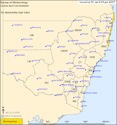
For people in parts of Northern Rivers and Mid North Coast Forecast Districts.
Issued at 5:03 pm Saturday, 1 January 2022.
HIGH TIDES MAY EXCEED THE HIGHEST TIDE OF THE YEAR FOR NORTHEAST NSW FROM SUNDAY MORNING
Tropical Cyclone Seth, currently over the Coral Sea, is forecast to move south towards the northern Tasman Sea on Sunday and Monday.
This system is generating increasing seas and swell, which will coincide with an astronomical peak in high tides over the coming days.
ABNORMALLY HIGH TIDES, which may cause sea water flooding of low lying areas are possible for coastal areas north of Port Macquarie.
Water levels could reach or exceed the highest tide of the year by at least 0.1 metres during the morning's high tide on Sunday, Monday and Tuesday mornings.
Increasing seas and swells are expected from Sunday afternoon, with the potential for dangerous surf conditions to develop on Monday, depending on the strength and movement of the tropical cyclone.
Large waves combined with higher than normal tides may increase the risk of localised coastal erosion, particularly for east facing zones.
A Hazardous Surf Warning has also been issued for the Coffs and Byron Coasts and will extend further south on Monday. Locations which may be affected include Coffs Harbour, Port Macquarie, Tweed Heads, Byron Bay, Ballina, Evans Head, Yamba, Woolgoolga, Southwest Rocks and Sawtell.
The State Emergency Service advises that people should:
* Don't drive, ride or walk through flood water.
* Stay vigilant and monitor conditions. Note that the landscape may have changed following bushfires.
* For emergency help in floods and storms, ring your local SES Unit on 132 500.


No comments:
Post a Comment