Showing posts with label Clarence Valley Council. Show all posts

Thursday 31 August 2023

The people of the Northern Rivers, wider New South Wales and the rest of Australia have been warned that the hands of the climate crisis clock are at 30 seconds to midnight, but it's business as usual


Australian climate scientist Dr. Joëlle Gergis, ANU Fenner School of Environment and Society and a lead author on the Intergovernmental Panel on Climate Change (IPCC) Sixth Assessment Report, has recently written


“The climate disasters unfolding in the northern hemisphere are a sign of what’s in store here, as governments fail to act on the unfolding emergency…..

...the possibility that the Earth might have already breached some kind of global “tipping point”. The term refers to what happens when a system crosses into a different state and stays there for a very long time, sometimes even permanently. We know that once critical thresholds in the Earth system are passed, even small changes can lead to a cascade of significantly larger transformations in other major components of the system. Key indicators of regional tipping points include dieback of major ecological communities….” [my yellow highlighting]


Such observations give pause for thought.


However, the elected Mayor of the third tier governing body for the Clarence Valley Local Government Area (LGA), Cr. Ian Tiley, is apparently comfortable with the idea of personally failing to act when it comes to any proposed phasing out of logging native forests in public hands within this LGA.


At least that is the impression he gives during a photo opportunity with representatives of the state government-dominated NSW logging industry.


Presumably Mayor Tiley is willing to ignore the fact that in 2021 & again in 2022 Australian university researchers warned that logging is not just increasing the risk of severe fires, but also the risk to human lives and safety.


Logging increases the probability of canopy damage by five to 20 per cent and leads to long-term elevated risk of higher severity fires, including canopy fires. Canopy fires are considered the most extreme form of fire behaviour and can be virtually impossible to control. 


It has also been known for the last two decades that intact tree canopies can buffer against rising and increasingly record air/land temperatures due to the thermal insulation of forest canopies which protects biodiversity, allowing native flora and fauna to survive climate change-induced heat extremes better than those living on open land.


Even the NSW Dept. of Infrastructure, Planning and Natural Resources in Land Condition in the Clarence River Catchment: Report 1 - when addressing forestry as a land use - admitted back in 2014 that:


Management of forested areas for bushfire control purposes can threaten adjacent areas, cause habitat loss and encourage erosion. Public debate on this issue has been centred around the in-situ environmental impacts of the process but smoke drift over nearby population centres and the post burning effects on water quality after erosion events also impacts water supply for urban and industrial purposes. [my yellow highlighting]


Commercial logging activity occurs within the Clarence River catchment area and logged state forests do catch fire - as evidenced by Ellis State Forest near Dundurrabin south of Grafton during the 2019-20 bushfire season.


Like many other communities in the Northern Rivers region during the 2019-20 bushfire season, communities in the Clarence Valley can attest to the physical difficulties of living for days and sometimes weeks under smoke palls loaded with gases and particulate matter (including PM2.5) with a potential to affect the health.


According to the Dept. of Health's Bushfire smoke and health: Summary of the current evidence, 6 August 2020:


The Global Burden of Disease Study has shown that outdoor PM2.5 is the most important environmental risk factor in Australia, responsible for 1.6 percent of the total burden of disease in 2017. 


Evidence shows that the likelihood of an individual experiencing health effects as a result of exposure to PM2.5 depends on a number of factors. These include: the concentration of PM2.5 in air, the duration of exposure; the person’s age and whether a person has existing medical conditions (particularly cardiorespiratory disease or asthma).


It is also acknowledged that while this document focusses on the evidence relating to the physical effects that may occur as a result of bushfires smoke, bushfires have much broader mental health and societal impacts.


Clarence Valley Independent, 30 August 2023:


*click on image to enlarge*

The Mayor also expressed his personal view, describing the timber industry as vital to the Clarence Valley.” 


I wonder if  Mr. Tiley will still be of that opinion over the next high-risk seven to seventeen years......


Sunday 16 July 2023

Tree by tree and hollow by hollow, regional coastal villages are being made over into the almost sterile landscapes of distant metropolises


All up and down the NSW coastal zone local residents are involved in conversations like this and, as in this case, local government staff are well aware of what is happening.


Concerning DA 2022/0100 - tree removal and erection of a shed - at 35 and 37 Riverview St, Iluka, at the mouth of the Clarence River estuary:


Click on image to enlarge


Melaleuca quinquenervia. Current common names: Broad-leaved Paperbark or alternatively Paperbark Tea Tree.

Tree grows 10 to 15m high and can live to more than 100 years. It produces clusters of cream to white flower spikes in summer, attracting birds, bats, bees and insects. Koala have been known to shelter in mature paperbark tree stands during storms or excessive heat. 

Grows on seasonally inundated coastal & near coastal plains, along stream banks and in low-lying coastal swamps.


Melaleuca quinquenervia is found as plantings in the grounds of The Royal Botanic Gardens and Domain Trust.


Hollow in mature paperbark prior to removal on lots 35 to 37 Riverview Street, Iluka. IMAGE: Contributed


Section of a felled paperbark on site showing hollow


REMARKS:


"They are dreadful images,.. and are pretty damning of the approval process. Those hollows should have been identified prior to clearing, and normally there should have been a requirement to have an ecologist or animal rescue person present at the time of felling. Microbats also live under the bark of those Melaleucas.


Of course, as Council refused to approve the hiring of an ecologist, they have no suitably qualified person to assess DAs, and are therefore at the mercy of the developer and what they chose to tell council.

[Email 11 July 2023, copied to Clarence Valley Council, councillors and relevant staff, transcript excerpt supplied]


NOTE: Paperbark tree taxonomy and general description have been altered since this post was first published.


Thursday 13 July 2023

In which the persistence of a millionaire Qld property developer is countered by the commitment of a Lower Clarence community to protect the James Creek precinct from overdevelopment and other harms


Clarence Valley Independent, 12 July 2023:


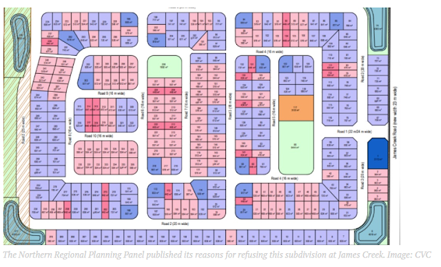
The Northern Regional Planning Panel has published its reasons for refusing a 336-lot subdivision at James Creek, a proposal that encountered hurdles satisfying council, which ultimately led to it not being recommended for approval.


When a development application DA was lodged with Clarence Valley Council in November 2020 for a staged residential subdivision on James Creek Road at James Creek, it proposed 342 lots, with 336 residential lots, a single park, and a neighbourhood centre for small scale retail.


Soon after the DA was lodged, The James Creek Residents Action Group was soon formed, and on December 7, 2020, the development application was withdrawn on behalf of owner Kahuna No 1 Pty Ltd.


A revised DA was lodged with CVC on November 4, 2021, for a 336-lot subdivision at 104 James Creek Road featuring 329 residential lots, one commercial lot, 4 drainage reserves and associated public space areas.


After working with CVC on the subdivision for more than a year, when Council staff completed their final assessment report for the Northern Regional Planning Panel NRPP, they recommended the subdivision be refused.


On June 29, 2023, when the NRPP met via videoconference to decide on the DA, after hearing submissions from 16 concerned locals, the subdivision was unanimously refused.


The NRPP published their reasons for refusing the DA last week, stating the application was refused for the reasons attached to the Council’s assessment report.


The Panel agrees with the council assessment that the proposed inward facing urban structure, density, and proposed lot design relates poorly to the existing topographical form and presents a stark change to surrounding rural and semi-rural setting and character,” the determination stated.


The Panel considers there is inadequate social infrastructure and services to support the proposed development including bus services and given the distances to local shops and facilities.


The Panel also concluded there was insufficient consideration of flood evacuation, but notes the verbal advice provided by Council staff of an offer by the applicant to upgrade Gardiners Road to enable evacuation in a 1:100 year flood event.


The Panel agrees with Council’s view that additional information and design amendments which might result in a more integrated ‘village’ style settlement may resolve these and other issues addressed in Council’s assessment report.”


In coming to its decision, the panel considered written submissions made during public exhibition and heard from all those wishing to address the panel.


The panel noted issues of concern included the impact on services, the lack of flood free access from Townsend along Gardiners Road, access to Austons Lane, stormwater management and flooding, impacts on adjoining rural land users and lack of buffers, inconsistency of development with planning proposal and adopted council policies, urban design and local character, traffic, transport and access, lack of Aboriginal cultural heritage assessment and consideration, a bushfire hazard, lack of public consultation and biodiversity.


The owner of lot 104 James Creek Road, Kahuna No 1 Pty Ltd now has the option of working with council to redesign the subdivision and relodge a revised DA, which they did with this DA, or decide not to pursue a subdivision on this site.


Australian Rural & Regional News, 5 July 2023:


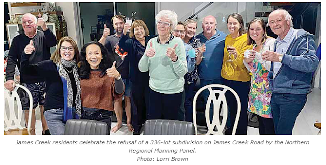
Cheers of celebration and relief from James Creek residents erupted when the Northern Regional Planning Panel refused approval for a controversial $33 million 336 lot subdivision on James Creek Road.


The panel met via teleconference on Thursday June 29, to decide whether to approve the development application DA by MPD Investments at 104 James Creek Road for 329 residential lots, one commercial lot, four drainage reserves and two open space areas on the 33-hectare site.


Clarence Valley Council’s assessment report for the ‘regionally significant development’, which required it to be decided by the Northern Regional Planning Panel (NRPP), recommended the DA be refused over concerns with sewage, stormwater discharge, traffic issues, land use conflict, the urban structure and sensitivity of the proposed design to the surrounds.


When the DA was put on public exhibition three times in 2022 and 2023, council received 100 submissions and a petition with 171 signatures against the subdivision.


Clarence Valley Council was represented by Cr’s Ian Tiley and Peter Johnstone on the five person NRPP, after Cr Greg Clancy declared a conflict of interest as he had been to a public meeting with complainants about the subdivision.


NRPP Chair Diane Leeson said there were 18 people registered to speak to the panel about the DA.


Speakers included James Creek resident of 30 plus years, Pat Bowen, and Lorri Brown who spoke on behalf of the James Creek Residents Action Group stating the development would double the population of the village, which went against council’s targeted growth figures for James Creek.


Carolyn Cameron, whose husband’s family settled in James Creek in 1863 said she feared ‘that our close-knit rural community is going to be lost’.


An emotional Sharon Farlow, who holds a routine movement stock permit to move her cattle along James Creek Road which her family has done for 100 years, feared with increased traffic her livelihood would be impacted.


Neighbour Keira Fahey urged the NRPP to follow council’s refusal recommendation as the buffer zone between the subdivision and other properties was not adequate…..


Read the full article here.


Sunday 28 May 2023

MEMO TO CURRENT & FUTURE AUSTRALIAN & NSW GOVERNMENTS: The Clarence Valley Was Declared A Nuclear-Free Zone On 23 May 2023


It was brief, to the point and supported by Clarence Valley Council’s Climate Change Advisory Committee and Council in the Chamber.


Ordinary Monthly Meeting of Clarence Valley Council held on 23 May 2023, Minutes, p.16:


ITEM 07.23.070 NUCLEAR FREE ZONE


SUMMARY

This report forwards a recommendation of the Clarence Valley Climate Change Advisory Committee

requesting that Council consider declaring the Clarence Valley a nuclear free zone.


OFFICER RECOMMENDATION

That Council support the Climate Change Advisory Committee recommendation and declare the Clarence

Valley local government area as a nuclear free zone.


COUNCIL RESOLUTION - 07.23.070

Pickering/Clancy


That Council support the Climate Change Advisory Committee recommendation and declare the

Clarence Valley local government area as a nuclear free zone.


Voting recorded as follows

For: Clancy, Day, Pickering, Smith, Tiley

Against: Johnstone, Novak, Toms, Whaites

CARRIED


NOTE:

Heartfelt thanks to members of the Climate Change Advisory Committee for mirroring the aesthetic, social, cultural, environmental and economic values of our Valley communities and, for the work put in to achieve this outcome: Cr Greg Clancy (Chair), Judith McNeill, Leonie Blain, Helen Granleese, Stephen Fletcher, Nicholas Reeve, Phillip Hocking, Janet Cavanagh, Geoff Little, Robert Mylchreest, Clair Purvis, Ian Gaillard, Lynette Eggins, Richard Roper (CVC Staff), Ken Wilson (CVC Staff), Scott Lenton (CVC Staff), Ben Ellis (CVC Staff), Suzanne Lynch (CVC Staff), Adam Cameron (Director CVC).


Thursday 18 May 2023

Yamba NSW 2023: is anybody listening?


The road into Yamba, Clarence Valley NSW, 4 March 2022
Credit: Clarence Valley Council via Storyful in Yahoo!


To put it frankly Yamba township’s flood resilience is a shambles.


Surrounded on all compass points by river, lake or ocean, much of the urban footprint of the town is built on degraded sand hills and reclaimed marshland or swamp across 16.92 sq km of coastal land.


The natural fingers of the Clarence River estuary which intrude into residential streets are now exacerbated by a fringe of canal estates which bring tidal riverwater right up to the artificial soft shore boundary edges of the backyards, side yards or front yards of so many homes and make it possible for riverine flooding to enter more streets than it once did.


Ocean storm surges occurring during destructive East Coast Low storm events are something that are considered almost in passing when it comes to resilience planning and flood risk management. Even though authorities are aware that days of heavy rainfall leading to soil saturation accompanied by strong seas result in est. 1 in 1,000 chance that land slippage will affect sections of Yamba Hill & environs public and private property – including residential dwellings. Such an event can coincide with riverine and stormwater flooding in wider Yamba.


The Lower Clarence River floodplain spans 500km2. That is a substantial floodplain and climate change modelling in BMT Lower Clarence Flood Model Update 2013 indicates that all along the lower river peak flood levels are expected to increase in 1% AEP events.


The natural protection of Yamba’s 690ha natural flood storage area has over time been eaten away by extensive landfill earthworks being created in preparation for housing another 2,000-2,500 people in West Yamba. While completed large scale earthworks elsewhere in Yamba are contributing to increased stormwater flooding adding to the volume of flood water flowing in from the Clarence River and into internal waterways and floodways of a town whose current population is 6,388 men women and children living in a density of 377.6 persons per sq km.


Coping with the town’s street plan and road surface heights which lead to predictable internal road closures during major flooding. These closures will inevitably occur ahead of any official advice to immediately evacuate during a Lower Clarence River flood. Currently it appears such emergency advice is not planned to be given until flood height reaches 2.1m at Maclean – at which point Yamba’s only evacuation route is highly likely to be closed in both directions.


In 2022 any evacuation by vehicle ahead of a flood front was calculated to take a minimum of one hour for the journey to Maclean via Yamba Road and the Pacific Highway to be completed. A journey that in good conditions might take twenty minutes. [C. Landers, Clarence Valley Council correspondence, dated 30 June 2022]


When it comes to Yamba residents and visitors; state & local government along with emergence services have placed the primary emphasis on “self-help" when coping with rising floodwaters or a need to evacuate, due to limited SES resources being spread across the valley.


Added to this is the fact that Yamba's flood heights expected ahead of active flood fronts and actual flood front heights as they reach the town are broad estimations. Because the town has to rely on the Maclean flood gauge further inland due to the strong tidal movement at the river mouth which is said to distort any flood calculations derived from the Yamba tidal gauge situated in the vicinity of the start of the southern breakwater wall.


Yamba is an accident waiting to happen and, it does not inspire confidence, when reading between the lines of the following newspaper article it seems that Clarence Valley Council administration is reluctant to obtain a written record of the lived experience of the wider population in Yamba over the last three decades. Something that would complement the data contained in the anticipated report by BMT WBM Pty Ltd.


Clarence Valley Independent, 17 May 2023:


The Yamba Community Action Network Yamba CAN Inc is urging Clarence Valley Council to conduct a flood survey of all residents on the Yamba floodplain so it can be incorporated in the updated Clarence River Flood Study and Flood Model which are currently being prepared.


Consideration of the impacts of the devastating floods in February and March 2022 will be factored into council’s new Flood Study and Flood Model, and Yamba CAN Inc believes the studies would be better informed if a survey was done to understand the impacts on individual residences.


When Yamba CAN recently discovered a flood study being conducted by Coffs Harbour City Council of residents in the Moonee Creek catchment area, members questioned why CVC couldn’t do the same.


Flooding impacts areas of Yamba differently, so to get a comprehensive picture of how the entire Yamba floodplain is affected, Yamba CAN Inc suggests CVC adopt a similar model to Coffs Harbour City Council, by asking each household to describe how they were impacted.


Questions in the Moonee Creek flood survey include: how long have you lived in the region; have you experienced flooding within the Moonee Creek catchment; have you experienced any other flooding event; please provide a short description of any flooding you have experienced; whether your home/business, garage, yard was flooded; were you able to drive your vehicle to safety; what areas of the community are most at risk of flooding; have you noticed any changes in the frequency or severity of flooding in your area and to provide photos and depths of the flooding.


From answers to these questions, Yamba CAN Inc asserts CVC could develop a comprehensive flood model of how individual residences are impacted in times of flood.


The important information obtained from the survey would assist with any upgrading of west Yamba’s stormwater drainage system.


Yamba CAN Inc sent a letter to CVC General Manager Laura Black, and all Clarence Valley Councillors calling for a flood survey of residents living on the Yamba floodplain to be included in the updated Flood Study and Flood Model.


It has come to Yamba CAN Inc’s attention of another flood study being undertaken by Coffs Harbour City Council in the Moonee Creek Catchment area,” the letter states.


This flood study includes gathering information from all residents in the Catchment area by means of a survey.


A similar survey of residents living on the Yamba floodplain is of paramount importance to be included in the current Flood Study and Model, particularly not only in relation to riverine flooding but stormwater flooding during February/March 2022 which occurred two days prior to the Clarence River flood crest reaching Yamba.


Yamba CAN Inc requests CVC undertake such a survey and the results be considered in the formulation of the current Flood Study and Model.”


A Clarence Valley Council spokesperson said council engaged BMT to undertake flood modelling using the latest available property and event data for the local government area to inform Floodplain Risk Management Plans.


The plan will be presented to the Council for exhibition, providing opportunity for the community to comment and provide feedback,” the spokesperson said.


The spokesperson said council doesn’t plan to do a survey of impacted residents in Yamba.


Council does not intend to survey individual households in relation to this matter,” the spokesperson said.


However, we will be undertaking a Yamba Urban Drainage Survey to capture residents experiences in recent events, as we are currently doing for Iluka.”


Tuesday 16 May 2023

YAMBA STATE OF PLAY: an example of state and local government wilful blindness that continues to this very day


A view of the lower section of Carrs Drive,
West Yamba Urban Release Area
IMAGE: Clarence Valley Independent, 7 May 2023


The original 127ha West Yamba Urban Release Area (WYURA) sits on a 690ha natural flood storage plain

This was an established fact in the early 1990s when urban settlement of this area was first mooted. It was still an established fact in 1995 when the local council adopted its Land Use Strategy

It remained an established fact when WYURA first came into effect in 2010 with amendments to the Maclean LEP 2001 allowing the amalgamated Clarence Valley Council to house between 2,000-2,500 people on flood liable land within a reduced 121ha urban release area.

It continued as an established fact in 2015 when Clarence Valley Council confirmed its ongoing intention to allow more dwellings per hectare via manufactured housing estates and therefore more people to be settled on this floodplain within the larger Lower Clarence River floodplain

Something then Clarence Valley Mayor and current NSW Nationals MLA for Clarence Richie Williamson called "good news for local development". Going on to say; "There's between 950 to 1000 lots and other land owners in the area will be moving forward with their developments. It's a massive development." 

It was an established fact in the years from 2015 to the present day, during which Clarence Valley Council received at least 9 largescale and 2 small scale subdivision applications on this flood liable land.

Look at that photograph again. At best, even with planned landfill this area will see 2,000+ men, women and children isolated in their homes when the road system is cut off by flood waters. 

Literally many hundreds of these residents will be retirees - with sometimes high levels of physical vulnerabilities. It is hard to see how emergency services, in a Yamba containing est. 7,000-8,000 residents by the time West Yamba is almost fully developed, will be able to cope during inundation caused by high rainfall events combining with a large riverine floods or heavy ocean storm surges.

The property developers don't care what the future holds, so it's more than time for Clarence Valley Council and the NSW Minns Government to enter emergency discussions concerning an immediate moratorium of further development in the West Yamba Urban Release Area.


Tuesday 9 May 2023

The Tweed, Clarence Valley & Byron Bay all have projects shortlisted for an award at 29th annual National Trust (NSW) Heritage Awards being held this Friday, 12 May 2023 in Sydney


Photo: InFocus2022 Compact Category winner Coastal Emus Walking, by Joy Hayman, depicts the emu projections with the Clarence River in the background. IMAGE: Clarence Valley Council Notice Board


The Building Bridges Emu Projection is shortlisted as one of eight finalists for the 'Events, Exhibitions and Tours' category in the 29th annual National Trust (NSW) Heritage Awards.


Events, Exhibitions and Tours

  • Building Bridges Emu Projection – entered by Clarence Valley Council

  • CAPTIVATE – entered by National Art School

  • Curios Shopfront Exhibition – entered by Haberfield Inner West Council Library and Haberfield Association

  • Guraban: where the saltwater meets the freshwater – entered by Hurstville Museum & Gallery (Georges River Council)

  • Mulaa Giilang: Wiradjuri stories of the night sky – entered by Orange Regional Museum

  • Rouse Hill Psychedelia – entered by Museums of History NSW

  • SHINE – Shining a Light on our Heritage and Museums – entered by Arts Mid North Coast Inc

  • Unrealised Sydney exhibition – entered by Museums of History NSW


The Clarence Valley Council entry involved Emu artworks by local First Nations artists celebrating the endangered coastal emu being projected onto the Sunshine Sugar building in South Grafton throughout the Jacaranda Season. Council worked with those local artists, Sunshine Sugar, Esem projects, Transport for NSW (TfNSW) and Australian Rail Track Corporation (ARTC) to bring this part of Clarence Valley Councils wider “Building Bridges” project to fruition.


This year the National Trust Heritage Awards are considering 40 rich and diverse heritage projects spanning across New South Wales in ten different categories.


In the Northern Rivers region Clarence Valley Council is not alone in being on this year's National Trust Heritage Award shortlists.


There are:

  • Conservation – Interiors and Objects: Green Frog Restoration – entered by Transport for NSW and Byron Bay Historical Society

  • Conservation – Landscape: Northern Rivers Rail Trail – Tweed section – entered by Tweed Shire Council


Winners will be announced at a lunch and awards ceremony this Friday, 12 May at the heritage-listed Doltone House, Jones Bay Wharf, 26-32 Pirrama Road, Pyrmont Point NSW.


Saturday 29 April 2023

Quote of the Month


 ..we’ve all had our lived experiences of floods of varying intensities. Now as intelligent human beings I think we can do better than what we’ve been doing.

We continue to build on floodplains and expect somehow some sort of different result. 

We talk about flood resilience and flood resilience is not living with its fingers crossed-type mentality.

Fingers crossed that it doesn’t rain too hard, too much. Fingers crossed that when it does the supermarket shelves are not stripped out. Fingers crossed that we can evacuate ourselves and if we can’t, fingers crossed the SES is going to come and look after us. And fingers crossed that if I do need medical help or to get out of Yamba, that road is not broken by flood water.”

[Cr. Jeff Smith, speaking in support of a motion to rezone undeveloped land in West Yamba Urban Release Area within the town’s natural flood storage area, Clarence Valley Council Ordinary Monthly Meeting,18 April 2023] 


Monday 24 April 2023

In 2023 is Clarence Valley Council preparing to walk away from a drowning town?


Aerial view of a section of Yamba township precinct during flooding in 2022. IMAGE: Clarence Valley Independent


On Tuesday, 18 March 2023 Clarence Valley Council held its Ordinary Monthly Meeting.


Officially present at that meeting according to the Minutes were:


Cr Greg Clancy [Deputy Mayor], Cr Bill Day, Cr Peter Johnstone, Cr Debrah Novak, Cr Steve Pickering, Cr Jeff Smith, Cr Ian Tiley [Mayor], Cr Karen Toms and Cr Allison Whaites, General Manager (Laura Black), Director – Corporate & Community (Alex Moar), Director – Environment & Planning (Adam Cameron), Director – Works & Civil (Jamie Fleeting) and Minutes Secretary (Lee Boon).


The fourth item of business for Council In The Chamber that day was the following Notice of Motion:


Item 06.23.004 Rezoning Lands on West Yamba Floodplain


Note: Crs Tiley and Johnstone left the Chamber ahead of this motion at 2:08pm, having asserted a non-pecuniary conflict of interest existed in relation to Item 06.23.004. Both noting sitting members on Northern Joint Regional Planning Panel. Under s6.1 of the Code of Meeting Practice, the Deputy Chair became the chair in the Mayor’s absence.


MOTION

Clancy/Smith


That Council:

1. note the legal advice tabled at the February Ordinary Council Meeting that compensation would not be

payable in the event that the Department of Planning and Environment, on the recommendation of

Council, was to approve a rezoning of lands in the West Yamba Urban Release Area (WYURA) from

residential R1 to C2 or a mix of C2 and RU2 depending on the results of the planning study;

2. prepare a planning proposal for submission to the Department of Planning and Environment requesting

that the vacant land, which do not have development approvals for subdivision, in the West Yamba

Urban Release Area (WYURA) be rezoned from Residential (R1) to Conservation (C2) zoning or a mix

of Conservation (C2) and Rural (RU2) based on the impacts of further development on the environment

and the risk to human life and property from future flooding.

Voting recorded as follows

For: Clancy, Smith

Against: Day, Novak, Pickering, Toms, Whaites

The Motion was put and declared LOST

[my yellow highlighting]


To say that the writer of this post is disappointed beyond measure at this outcome is an understatement.


Those names listed as voting down the re-zoning motion, Bill Day, Debrah Novak, Steve Pickering, Karen Toms and Allison Waites, should be noted for future reference by Yamba residents & ratepayers when - as landfill proceeds apace -  the next inevitable major Lower Clarence River flood arrives.


An alternate Motion in Item 06.23.004 was put up by Cr. Day & seconded by Cr. Smith and lost. That particular risible motion all but issued an invitation to the NSW Nationals to turn any rezoning of the West Yamba Urban Release Area into both a regional and state brawl along partisan political lines in which property developers would have eagerly participated. It was voted down by Crs. Clancy, Novak, Toms, Whaites.


BACKGROUND


SUMMARY

Approved development of the Yamba floodplain under the provisions of the West Yamba Urban Release Area (WYURA) planning approval has resulted in large amounts of fill being transported to the site, particularly along Gardeners Road, Yamba Road and Carrs Drive. The constant truck movements (1 every 10 minutes), has caused great consternation among a number of Yamba residents. The large amount of fill would appear to be exacerbating localized flooding around the Carrs Drive roundabout and the area surrounding it. There is also concern that the large amount of fill is affecting, and will increasing affect, the drainage of the area, adversely affecting low lying residences and the environment.


PROPOSED MOTION

That Council:

1. note the legal advice tabled at the February Ordinary Council Meeting that compensation would not be payable in the event that the Department of Planning and Environment, on the recommendation of Council, was to approve a rezoning of lands in the West Yamba Urban Release Area (WYURA) from residential R1 to C2 or a mix of C2 and RU2 depending on the results of the planning study;

2. prepare a planning proposal for submission to the Department of Planning and Environment requesting that the vacant land, which do not have development approvals for subdivision, in the West Yamba Urban Release Area (WYURA) be rezoned from Residential (R1) to Conservation (C2) zoning or a mix of Conservation (C2) and Rural (RU2) based on the impacts of further development on the environment and the risk to human life and property from future flooding.


The eighth item of business at that 18 April ordinary council meeting was a development application for a 6 lot subdivision of an existing parcel of land in West Yamba Urban Release Area, lodged on behalf of a commercial fisher-cum-property developer. 


It was refused as per COUNCIL RESOLUTION - 07.23.050

Clancy/Johnstone

That council refuse Development Application SUB2021/0045 for the following reasons covered by

Section 4.15 of the Environmental, Planning and Assessment Act 1979:

a) The land being a wetland (Swamp Forest of Swamp Oak) making it unsuitable for the proposed development;

b) The nine submissions raised major concerns about the potential for flooding, impacts of stormwater runoff and clearing of natural vegetation.

c) The likely impacts of the development on the natural environment;

d) Impact on areas of C2 zoning for some infrastructure.

Voting recorded as follows

For: Clancy, Day, Johnstone, Pickering, Smith, Tiley

Against: Novak, Toms, Whaites


DISCLAIMER: The author of this post is a Yamba resident living alone in a single storey dwelling in a street adjoining a 20 year-old 6.65ha landfill comprising est. 90,000 cubic metres of river dredge & soil. The street is regularly cut off by riverine floodwater, or a combination of floodwater and storm water, preventing access to the town's nominal evacuation centre. The author has no independent means of leaving the town if residents are advised to do so ahead of a large flood front. In 2022 a small number of houses within this short street experienced flooding.