This blog is open to any who wish to comment on Australian society, the state of the environment or political shenanigans at Federal, State and Local Government level.
Members
of NSW Parliament’s Portfolio Committee 7 (Planning and
Environment) are visiting Yamba to undertake site visits in relation
to the Parliamentary Inquiry into the “Planning system and the
impacts of climate change on the environment and communities.”
When
is the Committee coming to Yamba: Friday 31 May 2024
Time:
8.30am
The
Committee will be travelling down Carrs Drive. There
are strict protocols in relation to
observers remaining at a distance from the Committee visiting sites.
Yamba
CAN Inc would like as many people as possible to stand on either side
of Carrs Drive, near the access to Harold Tory Drive and O’Grady’s
Lane.
We
will have our banners and signs that observers can hold up when the
Committee will be driving past in a bus.
Please
ensure personal safety in relation to traffic movement.
Please
be on site at about 8.20am ready to hold a sign.
The
Portfolio Committee 7 Inquiry details and submissions can be seen at:
Please
see attached the NR Times and CV Independent articles this week.
Please
spread the word to others to attend and please outline that there are
strict protocols.
Secretary
Yamba
Community Action Network Inc (Yamba CAN Inc)
Follow
us on Facebook
*********
Note:
Portfolio
Committee No. 7 – Planning and Environment was established on 10
May 2023 in the 58th Parliament to inquire into and report on any
matters relevant to the public administration of:
Climate
Change, Energy, the Environment, Heritage, Planning
and Public Spaces
Section
of WEST YAMBA URBAN RELEASE AREA to the west (left) of Carrs Drive from
below Harold Tory Drive down to Miles Street. IMAGE: Google Earth. Click on image to enlarge
Plans
to build 1100 homes on a flood plain have triggered a wave of worry,
writes Linton Besser.
FOR
250 kilometres, the Clarence River snakes through northern NSW before
it meets the coast at Yamba.
There,
during heavy rain and high tide, the estuary spills its briny current
over a huge flood plain just west of the town. The 340 or so hectares
of salt marsh, melaleuca forest and mangrove swamp act like a giant
sieve, filtering the floodwaters as they make their way into Lake
Wooloweyah to the south.
Now
though, the Clarence Valley Council is one vote away from rezoning
the West Yamba flood plain and turning it into a busy residential
area.
In
a monumental decision, the council has foreshadowed dumping 270,000
truck loads of fill on the area to raise it high enough to make it
habitable.
Council
planners want the area to house a new population of 2700 people in
1100 dwellings, with development levies to pay for an overhauled
sewerage scheme, roads and other infrastructure.
But
green groups say the proposal, first mooted in 1995, will put Yamba
at risk from rising sea levels, and represents a dramatic threat to
the area's sensitive wetland ecology.
And
even the proposal's architect, the council's environment and planning
director, Rob Donges, acknowledges it is out of step with today's
planning regime.
"There
are acknowledged problems there. It is flood-prone, low-lying land
with a high water table," he said. "We have never hidden
the fact that if we were to start the process of West Yamba today
there would be doubts as to whether council would proceed."
The
council has not yet received the findings of a flood risk management
plan, commissioned to examine the effects of altering the area's
natural drainage corridors, but Mr Donges has recommended the draft
local environment plan go ahead anyway.
He
insists the wheel has turned too far to stop now……
NOTE: Former member of Maclean Shire Council & Clarence Valley Council senior planning staff, Mr. Donges now acts as a planning consultant, advising property
development companies and assisting with their development
applications. Applications he has been associated with include
large-scale subdivisions in Yamba(including West Yamba), James
Creek and elsewhere in the Clarence
Valley. Mr. Donges has previously been involved with the West Yamba Urban Release Area as a local government employee.
Section
of WEST YAMBA URBAN RELEASE AREA that is currently being developed. IMAGE:
Townes Contracting Group, 5 Riley Street, Tenterfield, NSW, 2372. Click on image to enlarge
Lot 245 / 22 Carrs Drive, West Yamba, multiple lot subdivision. Just one section of the total landfill which will be required across est. 127ha of a natural flood storage area .IMAGE: The Daily Telegraph, 31 May 2021.
It cannot be denied that all three tiers of Australian government - federal, state and local - contain elected members and bureaucracies capable of making bad decisions, indulging in blind self-interest and sometimes corrupt actions. One just has to look at NSW Independent Commission Against Corruption records since that body was created in 1998.
However, because there is an immediacy to local government, acting as it does in the midst of communities, it frequently becomes glaringly obvious when councils and developers collude to 'game' planning legislation, policy documents and guidelines.
From 1995 onwards, the Yamba community has repeatedly been told plans of plans to develop West Yamba only to see state and local government do the opposite of what had originally been proposed.
In both the original West Yamba development proposals and subsequent versions, both tiers of government were relying too heavily on the fact that by
the late 1950s & early 1960s the Clarence River floodplain had
become the largest regulated coastal floodplain in coastal NSW [Damian Lucas, 2004].
The Clarence River flooding nineteen times in a period of ten years (with the 1954 flood being the highest recorded to that
time) had slipped from memory and the dead forgotten.
Ignorant of the past; state and local government had become careless as to the consequences of their own policies and actions when faced with a consortium of developers who had virtually run out of land to be developed elsewhere in Yamba by the mid-1990s.
At the same time largescale development land in Yamba began to disappear, climate change became both a global and national issue.
Councils across the Clarence Valley and developers appeared to go into denial - nothing was going to happen in their lifetimes if it happened at all seemed to be the attitude. Maclean Shire Council (later amalgamated into Clarence Valley Council) was not immune to this way of thinking.
On paper this denial changed in 2010 when Clarence Valley Council adopted a "Climate Change Policy". Then proceeded in practice to ignore this policy when considering development applications lodged on known flood storage land in Yamba.
So despite knowing that Yamba is potentially exposed to almost the full suite of high range climate change risks - floods, bushfires, heavy rainfall events, destructive storms, ocean storm surges, sea level inundation, coastal and estuary foreshore erosion - Clarence Valley Council and successive NSW governments continued to happily ignore this small town's vulnerability whenever they decide to increase population density along the Clarence Coast.
Yamba, NSW 2464 - a timeline
Note: All yellow highlighting my own
1990 - The
first assessment report of the IPCC Working Group I including predictions of global warming and climatic
impacts, was released in June. The 4th session of IPCC was held in Sundsvall, Sweden.
Prime
Minister Bob Hawke announced the creation of nine
Ecologically Sustainable Development (ESD) Working
Groups in August.
1991
- Enumerated Yamba Population* 3,832 people
1992 - United Nations (UN) continues its 20 year-long raising of concerns with regard to the atmosphere and global climate, having previously adopted theEnvironmental
Perspective to the Year 2000 and Beyond
1995 - Maclean Shire Council rezoned land on the western side of Carrs Drive between Yamba Road, Oyster Channel and Sullivans Road as urban release land
Mr
Howard Bamse appointed Australia's Ambassador for
the Environment, based in The Hague, Netherlands, in May
1996
- Enumerated Yamba Population 4,915 people
Lower Clarence River floods**
1997 - UN adopts the
Kyoto Protocol to the UNFCCC.
Prime Minister John Howard announced the appointment
of Mr Roger Beale AM, Secretary of the Department of
Environment, Sport and Territories as the Prime Minister's
Representative on Climate Change in July
1999 - Department of Climate Change "Climate Change Risks to Australia's Coast: A First Pass National Assessment" released by Australian Government
2000 - United
Nations Climate Change Conference 23 October - 1 November
2001
– Enumerated Yamba Population 5,818 people
Lower Clarence River floods in February-March
Australia
could expect to see many more floods like those afflicting northern
NSW if global warming were not slowed, an international climate
change expert said yesterday.
Intergovernmental
Panel on Climate Change vice-chairman Tomihiro Taniguchi said
increased flooding in many parts of the world in recent years
indicated the impact of global warming was starting to be felt.
[The
Australian,
13 March 2001, p.5]
2002
Ongoing
community action is trying to stop a 3000-person residential complex
from being built in a flood-prone estuary at West Yamba.
[The
Daily Telegraph,
2
April 2002, p.8]
2003
West
Yamba
100
houses [between Park Ave & Telopea Ave] adjacent to Wattle Park, requiring 90,000 cubic metres of
infill dredged from the Clarence River.
[The
Sydney Morning Herald,
9 August 2003, p.29]
2005
In April 2005 the NSW Government released the Floodplain Development Manual: the management of flood liable landwhich had "the primary objective" of reducing "the impact of flooding and flood liability on individual owners and occupiers of flood prone property". This manual placed the main responsibility for ensuring its aims were met on local councils. Including that in the selection of flood prone land for development councils are required to "Identify areas where development significantly impacts on flooding elsewhere". Conveniently, the manual also points out that under Sec 733 of NSW Local Government Act (1993) councils are all but absolved from legal liability with regard to their planning decisions, advice and actions, it being assumed that they act in good faith.
The
Total Environment Centre has asked the NSW Government to stop an
expansion of development at West Yamba.
Clarence
Valley Council has voted for smaller lots in West Yamba, which could
eventually see the population reach 2,900.
The
centre's coastal campaigner, Fran Kelly, says development in the area
could lead to significant environmental damage.
"Environmentally
it's a very sensitive area because it drains eventually into
Woloweyah Lagoon, the Clarence Estuary, which is a very sensitive
area," she said.
"The
second thing is the flood risk, because not only have they expanded
the development, they've ripped back the riparian buffer zone, which
is there to protect the environment and to lessen the risk of flood.
It's just an incredibly inappropriate area for development."
[ABC
Regional News, 6
December 2005, p.1]
2006
– Enumerated Yamba Population
6,021 people
Lower Clarence River floods in August
2007
For
250 kilometres, the Clarence River snakes through northern NSW before
it meets the coast at Yamba.
There,
during heavy rain and high tide, the estuary spills its briny current
over a huge flood plain just west of the town. The 340 or so hectares
of salt marsh, melaleuca forest and mangrove swamp act like a giant
sieve, filtering the floodwaters as they make their way into Lake
Wooloweyah to the south.
Now
though, the Clarence Valley Council is one vote away from rezoning
the West Yamba flood plain and turning it into a busy residential
area.
In
a monumental decision, the council has foreshadowed dumping 270,000
truck loads of fill on the area to raise it high enough to make it
habitable.
Council
planners want the area to house a new population of 2700 people in
1100 dwellings, with development levies to pay for an overhauled
sewerage scheme, roads and other infrastructure.
But
green groups say the proposal, first mooted in 1995, will put Yamba
at risk from rising sea levels, and represents a dramatic threat to
the area's sensitive wetland ecology.
And
even the proposal's architect, the council's environment and planning
director, Rob Donges, acknowledges it is out of step with today's
planning regime.
"There
are acknowledged problems there. It is flood-prone, low-lying land
with a high water table," he said. "We have never hidden
the fact that if we were to start the process of West Yamba today
there would be doubts as to whether council would proceed."
The
council has not yet received the findings of a flood risk management
plan, commissioned to examine the effects of altering the area's
natural drainage corridors, but Mr Donges has recommended the draft
local environment plan go ahead anyway.
He
insists the wheel has turned too far to stop now.
"It
has a long history and commitments [have been] made by the council."
These
commitments were about the provision of new infrastructure, he said,
and did not extend to catering for the developers waiting to swoop.
Of
those who stand to profit most is one of Yamba's best-known
residents, the founder of Billabong and surf star Gordon Merchant.
Part-way through construction of his $10 million brick and tile beach
pad four kilometres outside town, at Angourie, the Queensland-based
tycoon has rolled his dice on the West Yamba flood plain.
Between
July and October last year, through his company Kahuna No. 1 Pty Ltd,
Mr Merchant bought 60.5 hectares for a total of $7.753 million. Most
of this has been slated for a lucrative 2(c) zoning, allowing the
greatest density of 10 dwellings per hectare. He did not respond to
enquiries from the Herald.
Other
speculators include two local brothers, Mark and David Mitchell, and
a Terrigal-based investor, Mark Lawsen.
Mr
Lawsen plans to build a retirement village, private hospital and
shopping centre on his land, and has been vocal in his criticism of
the council for not allowing far higher densities.
But
the most noise has been made by a loose coalition of
environmentalists, who say the council is about to commit an act of
environmental vandalism.
"When
you raise the ground level, the displaced water has to go somewhere,"
said Helen Tyas Tunggal, of Valley Watch.
"Other
more established areas of town will flood as a result."
During
last week's council committee meeting, Leonie Blane of the Clarence
Valley Conservation Coalition mounted an attack on the proposal's
very foundations.
"We
are concerned about the amount of fill," she said. "Firstly
the effects on the environment from where the fill is sourced and
[secondly] on the drainage and water quality in the area."
Mr
Donges said the problem of where the fill would be sourced would be
solved when developers submitted subdivision master plans.
He
has flagged, however, the possibility of dragging it from the bottom
of the Clarence River.
It
is unclear what the council will decide when it meets tomorrow. The
committee meeting featured a new, cautionary note among the
councillors in attendance.
"It
may be that people who are flood-proof at the moment will be put at
risk," the Mayor, Ian Tiley, told the meeting.
"A
great deal has happened since the council [first] decided to increase
[the area's] yield. From the middle of last year a great awareness of
climate change issues [has surfaced]. It is a whole different ball
game."
If
the council adopts the local environment plan it will be sent to the
NSW Planning Minister, Frank Sartor, for ratification.
He
has already issued a Section 65 certificate, giving conditional
support for the proposed rezoning.
A
department of planning spokeswoman, Lyndall Derrig, said the Clarence
Valley was identified in the Mid North Coast Regional Strategy as the
future hub of another 7000 dwellings.
"Flooding
issues will be assessed carefully in the department's consideration
of the draft [local environment plan, which] also proposes to protect
and zone lands with significant environmental values."
[The
Sydney Morning Herald, 19 March 2007, p.2]
Conservationists
have accused the New South Wales Planning Department of bowing to
"developer pressure" in suddenly doubling the estimated
population growth for the mid-north coast.
The
department's regional strategy now has enough land set aside for
future residential development to cater for 70,000 residents.
Total
Environment Centre spokesman Jeff Angel says the original estimate
was for 35,000 new homes in the area stretching from the Clarence to
the Great Lakes.
"We're
stunned that they have double the population requirement," he
said.
"We
can only surmise that there's been pressure from developers to
include some controversial areas such as North Arm Cove, Bonville,
west Yamba near Grafton, and that they've had to upgrade the figures
to appear to make that land grab justifiable."
[ABC
Regional News, 21 December 2007,p.1]
2008
Persons
associated with proposals to develop West Yamba would be well advised
to take special note of a decision of the NSW Land and Environment
Court.
In
an article headed Court agrees climate-change risk rules out housing
plan The Sydney Morning Herald (January 8, 2008) reports:
"Many
may be pleased to know the Land and Environment Court can overturn
not just a council decision but a ministerial one.
The
court recently ruled invalid a concept plan approved by the Minister
for Planning, Frank Sartor, for a controversial residential
subdivision and retirement complex at Sandon Point, on the coast near
Wollongong. The action was brought by a resident, Jill Walker.
The
court agreed the department should have considered the flooding risk
from climate change as it was an aspect of the public interest that
potentially had a bearing on the justice of the decision.
The
decision is a win for residents who have been protesting for years
against the development of the flood-prone 25-hectare site by
Stockland Development and Anglican Retirement Villages.
Deacons
Lawyers said councils would have to ensure risks from climate change
in flood-constrained coastal areas had been addressed by developers
and that they considered such risks in their decisions."
Comment:
The
land at West Yamba is flood-prone. Allowing further development in
the area will require fill being obtained from elsewhere in order to
raise the area above designated ASL requirements. That may solve
current problem associated with the West Yamba site but one doesn't
have to be Einstein to understand that water which would normally
find its way to this naturally occurring flood storage area in times
of heavy rainfall will be diverted elsewhere. And just where is
elsewhere? Think about it. Land that is currently occupied and
considered flood free will not necessarily carry such a tag in the
future.
Yes,
further development at West Yamba will create a new set of winners
(just think 'developers and their associates'), but there'll also be
a crew of losers who'll be up the creek without paddles in times of
high local rainfall and/or flooding that results from waters flowing
downstream from the catchment area.
Clarence
Valley Council should have this matter uppermost in its collective
mind. So too, should Minister Frank Sartor and all others who will be
called upon to give consideration to any hair-brained proposals to
develop West Yamba.
Remember,
the law attaches great significance to the concept of precedence.
Hence, this decision of the Land and Environment Court has
implications for West Yamba.
POSTED
BY CLARRIE RIVERS
[North
Coast Voices, 8 January 2008]
The
Department of Planning's draft regional strategy, now on public
exhibition, identifies three areas as problematic because they are
either flood-prone, environmentally sensitive or lack infrastructure.
They include West Yamba, South West Rocks and North Arm Cove.
[The
Sydney Morning Herald, 14 April 2008, p.6]
Because
of its location, demographer Bernard Salt has pin-pointed Yamba as
the next NSW North Coast "boom town".
"Yamba
is a place to watch out for -- it's the next cab off the rank after
Byron Bay," Mr Salt said.
He
said the combination of an upgraded Pacific Highway and sea- changers
making the move, cash in hand, had made it a prime target for
developers to swoop in…..
Don
and Jan Veale, who have been coming to Yamba from Armidale for 33
years, said the area had certainly changed dramatically.
"I
remember the days when there was just a small number of shops and
houses -- these days it doesn't look like the same place," Mr
Veale said.
"It's
a shame because there is nothing like this up and down the coast but
that's progress."
The
latest controversial development proposed for the town is a whole new
suburb called West Yamba -- with a projected population of up to
2900.
[The
Daily Telegraph, 15 January 2008, p.11]
FUTURE
DEVELOPMENT
All
existing residential zoned land in Yamba has been developed (apart
from isolated infill lots) and combined with a population and tourism
growth of 3% per annum, there has been increasing pressure to develop
new areas. Consequently development has been proposed for West Yamba
and a draft LEP went on Public Exhibition from August to October
2006. There are a number of issues relating to this site (including
flood-related) and it is not yet certain that the development will
proceed. The only alternative to this is intensification of the
existing developed areas. Both scenarios are discussed in this
Floodplain Risk Management Study as it is imperative that any
additional development doesnot exacerbate the existing flood
problem….
A
number of issues need to be addressed prior to the development
proceeding, including: impacts of fill, evacuation planning,
environmental management and compliance with policies and plans.
Development
controls for the development would ensure that the nature of the proposed development isappropriate for the floodplain and the
flood hazard is acceptable.
The Daily Examiner: Yamba from the air showing a section of Crystal Waters, Oyster Cove and West Yamba, May 2009.
The
Floodplain Risk Management Study indicates a storm
surge warning time
of 6 to 24 hours. It should be noted
however that the flood
hazard can become high if the low
lying community to the west
of the town does not respond
to flood warnings as the available high ground is only
accessible by Yamba Road, which is readily cut
by
floodwaters. The only road out of Yamba to the Pacific
Highway is
also inundated in the 10y ARI and greater
flood events.
[Clarence
Valley Council, Yamba Floodplain Risk Management Plan, February
2009]
Yamba
does not have a flood evacuation plan, with the State Emergency
Service being the lead response agency in the event of flood.
In
a submission to council during the community consultation process on
any development at West Yamba, the SES stated that "It does
currently consider the evacuation of the community at risk of
flooding to be problematic due to access and the need for an
evacuation shelter".
It
stated that the development of an adequate strategy for Yamba is
required regardless of the development of West Yamba, and recommended
in effect that the local environment plan (LEP) be deferred pending
the floodplain management plan.
[Daily
Telegraph,
17 April 2009]
Yamba
is a town of approximately 6000 residents sitting on predominately
low-lying land surrounded on all four sides by tidal bodies of water
and tethered to the mainland by a strip of land approximately 1.25
kilometres wide, according to a scaled map.
On
April 17, The Daily Examiner published a front page article Yamba
Prone To Disaster?
This
article pointed out that Yamba will have difficulties coping with the
predicted bigger floods of longer duration and increasingly severe
storms accompanied by storm surges.
Part
of this difficulty is the limited evacuation options open to
residents should Yamba Road be cut by floodwater in any of the three
to four places it has been cut in the past, thereby denying access to
high ground at Yamba Hill for a considerable number of residents
and/or preventing movement inland towards Maclean or the Pacific
Highway.
Floodwater
in certain side roads or across Angourie Road will also cause
problems for residents seeking high ground.
The
Daily Examiner article went on to say that the State Emergency
Service (SES) was concerned about this situation and that its
submission to Clarence Valley Council regarding proposed large-scale
urban development in Yamba recommended in effect that the Maclean
Local Environmental Plan 2001 (LEP) amendment for West Yamba be
deferred pending further study.
The
SES were right to draw council's attention to the problems which may
be experienced as severe weather events become more common.
According
to Clarence Valley Council documents, Yamba flooding can occur
because of a combination of high river flows, high ocean levels,
wind-wave action along the foreshore or from intense rain over the
local catchment (Webb, McKeown and Associates, 2009, 'Yamba
Floodplain Risk Management Plan').
According
to the US National Oceanic and Atmospheric Administration, a storm
surge is a large amount of water pushed towards the shore, which
combining with the existing tide and/or floodwater, raises the mean
water level by 15 feet or more depending on the inclination of the
underwater shelf leading to the foreshore.
Wind-driven
waves are superimposed on this surge and the total effect is often
swift and destructive flooding of coastal areas ( www.nhs.noaa.gov,
April 18, 2009).
It
is easy for the average person to recall that in the last decade
storm surges have caused loss of life in America, India, South-East
Asia and New Guinea.
It
is also easy for Yamba locals to recall that severe 'east-coast lows'
are sometimes preceded by days of rain and have been known to follow
close on the heels of a Clarence Valley flood.
So
here we have a town, with a large retiree population, two aged-care
facilities and more than a few people without a car, faced with the
probability that from now on it will be more vulnerable in floods and
severe storms and, that there may be some risk to life as well as
anywhere between $1.9 million to $113.7 million worth of property
damage from any one severe adverse weather event (Webb, McKeown and
Associates, 2009, 'Yamba Floodplain Risk Management Plan').
What
does Clarence Valley Council do when faced with this risk scenario?
Does
it look at the recent reports from reputable CSIRO researchers which
state that sea levels are rising faster than was thought (University
of Copenhagen, 2009, Climate Change International Scientific
Congress) and move to protect existing residents by immediately
beginning to organise a co-ordinated emergency evacuation plan? No,
it does not.
What
is does is decide to progress the proposed development of West Yamba
(based on what appears to be 2007 predicted sea-level data), thereby
eventually adding another 2000 to 2500 people to an already
vulnerable population and taking away yet another section of local
flood storage land, at the same time deciding that it will ask for
money from a cash-strapped NSW Government to put together some sort
of plan with the help of emergency services at some indefinite point
in the future.
Why
does it do this?
Well,
on reading council's February 24, 2009 ordinary monthly meeting
minutes and attachments, it appears that it has accepted the argument
that to defer the LEP amendment would not be 'considered reasonable'.
So intent are our nine councillors on appeasing a select group of
property speculators and so determined are they to widen the Yamba
rate base, that these same councillors are willing to ignore their
duty of care and the risk to residents' lives in favour of being
'reasonable'.
Clarence
Valley Council obviously has not taken note of the fact that should
individuals in the expanded Yamba population experience property loss
or loss of a family member as a result of predicted flooding/surges,
it would be within the realms of possibility that council would face
both individual litigation and a class action.
Our
nine councillors should also remember that, in certain circumstances,
they do not have full indemnity for the resolutions they pass. Or
perhaps they do remember and that is the reason for the deafening
silence on the subject of Yamba since they passed the West Yamba
amendment?
JUDITH
M. MELVILLE Yamba
[The
Daily Examiner, 17 April 2009]
If
sea levels rise 1.1 metres by 2100, large parts of the Clarence
Valley could be under water and towns may have to be relocated.
It
sounds like a dooms day prediction, but according to a report
released this month by the Department of Climate Change titled
Climate Change Risks to Australia's Coast, this warning is based on
credible science and is a scenario we should all be preparing for.
The
report's worst case scenario for the Clarence Valley is that up to
900 homes will be at risk of inundation from sea level rise by the
end of the century.
At
best, about 400 homes will be at risk and that is not including homes
to be built in the future.
The
report lays the cause of rising sea levels squarely on climate
change.
It
suggests extreme weather events will also be likely to become more
intense, with larger and more damaging storm surges and the possible
extension of cyclones further south.
"The
current 1-in-100 year event could occur several times a year,"
the national report said.
According
to computerised modelling based on a 1.1 metre sea level rise, homes
near the coast and in low-lying parts of the Valley could be under
water or prone to inundation.
This
includes large areas of west Yamba, islands in the Clarence River,
west of Lawrence, Shark Creek, Lower Coldstream, Tucabia through to
Sandy Crossing, Southgate, Ulmarra, Great Marlow and Alumy Creek.
Populated
villages along the Clarence Coast would also be prone to inundation,
including Iluka, Yamba, Brooms Head, Sandon and Wooli.
Clarence
branch secretary of Climate Change Australia Janet Cavanaugh said it
was no longer a question of if sea levels were going to rise, but how
quickly and by how much.
She
said it was important all government levels started incorporating sea
level rise forecasts into planning for future infrastructure and
buildings.
"We
really need to start thinking about the new sites we're going to
develop and where we're living," Ms Cavanaugh said.
She
said opening up land to development on the flood plain would be
short-sighted.
"Like
the whole West Yamba proposal," she said.
"We
need to pull back and think about whether this is something we need
to be doing."
Areas
usually protected by levy walls could also be affected.
"We
also need to start thinking about what will happen in Grafton
itself," Ms Cavanaugh said.
"There
will be more flood events where people will have to be evacuated.
"But
what happens when it comes every year or every second year.
"Will
we still live there?"
"It's
one of those hard decisions we'll need to make."
[The
Daily Examiner, 24 November 2009, p.5]
2010
Local
developer, Ron Kohler of East Coast Pty Ltd, said that blocks of land
for sale in Yamba and Maclean today are hard to get.
His
past projects have included Yamba's Oyster Cove as project director,
Osprey Park, extending Lake Kolora and Matthew Flinders one and
three-estate developments, as well as proposals for development of 15
hectares in West Yamba.
[The
Daily Examiner, 21 January 2010, p.3]
The
NSW Minister for Planning has approved the residential rezoning of
Yamba's last available land release at West Yamba.
Clarence
Valley Council was notified this week of the local environmental plan
approval 'with minor modifications'.
The
plan will take effect when the approval is posted on the NSW
legislative website as early as today. Minister for Planning Tony
Kelly said he had approved the rezoning.
It
includes around 124 hectares of land zoned urban residential with the
potential to deliver 1200 lots - approximately 60 hectares of land
zoned rural residential with the potential to deliver around 110 lots
- and 116 hectares of land zoned for environmental protection
purposes.
"West
Yamba has been designated for residential use in council's strategic
planning since 1995, and is also identified as a release area in the
NSW Government's Mid North Coast Regional Strategy," Mr Kelly
said.
Mr
Kelly said he had made amendments to the council's plan, which would
help protect the local environment.
"I
have introduced a 10-hectare minimum subdivision standard for the
residential habitat environmental protection zone, up from the
council's proposed two-hectare minimum subdivision size," Mr
Kelly said.
"This
will ensure there is improved protection for key environmental areas,
such as sensitive paperbark forest and remnant rainforest areas.
"Development
has also been prohibited along an identified drainage corridor, which
will assist water flow across the site."
He
said that due to the extremely large size of the floodplain around
the development site, it is expected that any filling would have a
negligible or no impact on local flooding patterns.
Dougherty
Bros Pty Ltd owns around 10 hectares in West Yamba with the potential
for 100 residential blocks under council's draft LEP.
"This
is much needed land in Yamba and although the biggest hurdle
(approval) has been overcome, it will be some time before we see land
available," Jim Dougherty said.
Council
will now have to formulate a development control plan for the area
and pressure will now be on to upgrade the town's sewerage system.
[The
Daily Examiner, 22 April 2010, p.1]
The
population of the Clarence Valley could grow by the equivalent of
three Yambas or another Grafton within the next 20 years, according
to the Clarence Valley Council.
Council
deputy general manager Des Schroder said Department of Planning
figures suggested that by the year 2030 there would be an additional
7100 dwellings in the Valley.
With
an average of 2.5 residents per dwelling, that is an extra 17,750
residents.
The
growth appears to be spread across the Clarence Valley, with land
releases occurring from Yamba to Clarenza.
Mr
Schroder said close to 5000 housing lots would be coming onto the
market soon.
This
included 1100-plus in west Yamba, 350 at Clarenza (with another 650
to come later), 1000 at Junction Hill, between 800 and 1000 in the
Gulmarrad and Townsend area, about 300 on the hill in South Grafton,
and 300-400 at James Creek.
Mr
Schroder said the Valley population had been growing at a rate of
about 500 a year, but that was likely to accelerate as neighbouring
areas ran out of land available for housing development.
"Lismore,
for example, has got nowhere to go," he said….
Growth
at a glance
7100
extra dwellings by 2030
17,750
extra residents by 2030
Land
releases at
-
Yamba ...1100+ lots
-
Gulmarrad/Townsend ...800-1000 lots
-
Clarenza ...350 (eventually 1000)
-
Junction Hill ...1000
-
James Creek ...300-400
-
South Grafton hill ...300
[The
Daily Examiner, 22 May 2010, p.1]
2011
– Enumerated Population 6,646 people. Lower Clarence River floods in January
After
much discussion at a full meeting of council, however, councillors
voted against the officers' recommendation; instead deciding to leave
the bypass option open.
The
proposed bypass would extend from Oyster Channel to the Yamba town
centre at Coldstream Street, easing the traffic congestion along
Yamba Road, particularly during peak traffic periods.
The
particular site was identified many years ago and encapsulated in the
Maclean LEP 1992 as the Yamba Urban Bypass.
In
the late 1990s, a Section 94 Plan was adopted to partially fund a
part of the bypass linking Shores Drive to Coldstream Street.
The
report said the time-frame set for that plan was 20 years, with
subsequent stages likely to take even longer.
The
then-Maclean Council reviewed the proposal in 2003-03 in terms of the
bypass's feasibility.
It
decided there was a traffic need for the bypass which would provide
future access required by the West Yamba land release.
It
also determined the Yamba community should be given the ability to
build a bypass along the proposed route at some time in the future,
rather than leaving future generations with a lost opportunity.
Clarence
Valley Council general manager Stuart McPherson said there was no set
time-frame for the bypass's construction but confirmed that council
was still committed to proceeding with the project…..
"So
it's several years away yet but it would be particularly relevant
once the West Yamba development proceeds."
Mr
McPherson said the Yamba bypass was never intended to duplicate Yamba
Road for its full length; simply to be a second road made even more
necessary following West Yamba's development.
And
that (West Yamba's development), he said, was still a few years away.
"That
will probably happen in four or five years' time, depending on the
availability of sewerage," Mr McPherson said.
"It
(Yamba bypass) was always seen to be tied up with the West Yamba
development.
"It
was conceived at a time when the West Yamba development was expected
to yield a lot more house lots than it is now expected to yield."
[The
Daily Examiner, 11 January 2011, p.7]
Planning
ahead
My
small home town of Yamba on the North Coast has been cut off for
several days now due to the flood. Fortunately, we still have a few
flood plains that can take some of the excess.
Yet
some of this flood land in West Yamba has been given housing approval
by the NSW Planning Minister Tony Kelly.
This
irresponsible action is typical of the short-sighted views of
government and their inability to take the excesses of the Australian
climate seriously.
Paul
Stephen Yamba
[The
Daily Telegraph, 15 January 2011, p.32]
Mr
Schroder said growth predicted in the Mid North Coast Regional
Development Strategy would see 7100 dwellings built in the Valley by
2031.
Housing
development slated around Grafton includes more than 1000 dwellings
at Clarenza, 800-1000 homes at Junction Hill and 500 lots on the hill
at South Grafton.
Down
river would see 800-1000 homes at Gulmarrad, 1100 lots at West Yamba
(subject to filling), 350 lots at Iluka (when sewerage is connected)
and around 200 lots at Lawrence.
"Most
of that has been or is in the process of being rezoned," Mr
Schroder said.
He
said the Clarence Valley was in a better position to capitalise on
the growth than nearby councils…..
Predictions
by the National Sea Change Taskforce estimate the population in
regional areas on the East Coast could grow by 94% or more than six
million people during the next 40 years.
As
a consequence real estate prices in regional coastal areas are
predicted to soar.
[The
Daily Examiner, 31 March 2011, p.1]
2012
In
February residents in the vicinity of Cox St, Yamba received a notice
from council informing them that an environmental consultant was
undertaking a flora and fauna study of bushland near their
properties. The study was associated with council considering the
design of the section of the Yamba motorway from the Yamba Rd/Shores
Dr intersection following the Cox St and Deering St alignment to
service Yamba industrial estate and West Yamba Development Area
(WYDA).
Residents
wrote to council seeking detailed information about the motorway.
Council replied on May 3, stating that the situation was "no
plans or funds to build an extension to the existing section of
by-pass (near Yamba Business Park) and no demand for such an
extension".
"At
some time in the future when West Yamba has developed ... Council may
have to build a further section of the bypass though that may not
necessarily involve the section adjacent to Cox Street ... so in
conclusion ... the current situation is no plans, no funds and no
need".
Not
satisfied with that somewhat dismissive response from council, the
group wrote again to council and sought specific details about any
environmental issues that might affect the bypass's alignment in our
area (i.e. what did the environmental consultant discover?).
On
May 30 council replied. The consultant's investigation revealed an
endangered orchid along with a bird and nocturnal gliding possum that
are both listed by the NSW Scientific Committee as vulnerable
species. Council decided not to spend further funds at this stage on
a Species Impact Statement, but rather adopt a centreline through the
middle of the road reserve near Cox St. Council also added that a
report was being prepared for its Civil and Corporate Committee
meeting on June 12.
Ok,
so taking council at its word, things were not progressing too far,
were they?
Then,
on May 31, council dropped a bombshell. It sent the group a copy of a
report along with maps of Yamba showing various options for the
bypass that the committee would consider. The council officer's
recommendation was for an extension of the existing road near Yamba
Business Park to a proposed roundabout near the Cox St and Golding St
intersection which would lead to Miles St in West Yamba. Further
roundabouts/traffic management devices at Coldstream St/Yamba St,
Coldstream St/River St, Angourie Rd/Bypass and Quarterdeck Pl/Bypass
were recommended.
However,
on June 12 the Civil and Corporate committee went the whole hog and
adopted a proposal to extend the bypass from Coldstream St all the
way through to Yamba Rd at Shores Dr with all the roundabouts/traffic
management devices previously mentioned.
The
next chapter will unfold on June 26 when the committee's decision
will be examined by a full meeting of council.
Pity
about the lack of information and the lack of community consultation
about these developments.
Residents
and ratepayers expect transparency in all decisions council makes and
genuine community consultation is an integral part of good
governance.
Col
Shephard Yamba
[The
Daily Examiner, 16 June 2012, p.14]
Near
the coast, unusually high tides can produce inundation of land which
is usually dry. Thunderstorm activity, especially when it occurs in conjunction
with such tides, can produce significant local ponding in Iluka and
Yamba.
Between
Palmers Island and the river’s mouth there is an increasinginfluence
of ocean storm tide conditions and peak flood levels at Yamba are
dictated almost entirely by ocean storm tides. Storm activity over
and off the coastline normally brings flood-producing rains over the
land mass, with peak catchment runoff flows occurring sometime after
the storm activity itself.
[State
Emergency Services (SES), Clarence Valley Local Flood Plan,
July 2012]
We
all want a "can do" council but this must only be done with
consideration for our ecological environment and our natural and
human-made heritage. Too often during the past four years I have seen
development and rezoning (eg West Yamba) proceed without adequate
vegetation corridors and recognition of our heritage listed
buildings.
Margaret
McKenna South
Grafton
[The
Daily Examiner, 20 August 2012, p.18]
Yamba
environmental group Valley Watch may have to sit by and do just that
as the council votes for West Yamba to be developed.
The
debate over whether or not development at West Yamba is sustainable
appears to be reaching a conclusion despite opposition from some
local residents.
Valley
Watch member Ros Woodward said she was disappointed to see the
development go through without proper consideration for the sensitive
natural environment around it.
"West
Yamba could be an example to the world of how to develop sustainably
with a small footprint in a very sensitive area, but I am afraid all
they can envisage is slab houses on great big mounds," Ms
Woodward said.
A
submission from Valley Watch raised concerns about how sewage would
be dealt with in the development and how practical the filling
solution was in the area.
Clarence
Valley Council deputy general manager Des Schroder said, "The
bottom line is this land has been rezoned and that was approved by
the Minister for Planning. From every aspect this has been studied
and worked on. People who say filling is not sustainable should
realise that a lot of Yamba has been built of fill already."
Mr
Schroder said studies had shown Yamba would be more economically
sustainable with a population of 10,000 residents than it was with
7000.
The
Department of Planning backed the council's position.
[The
Daily Examiner, 16 October 2012, p.4]
DA
concern
It
is with a sense of foreboding that I notice that once again council
will consider on Tuesday a subdivision on Carrs Drive, West Yamba.
This time the proposal is for 15 lots instead of 22, but fundamental
problems of sewerage, fill and truck movements remain.
Since
Maclean Shire Council endorsed in November 2003 the recommendations
of the Yamba Wastewater Management Strategy, the community has been
told regularly that development of West Yamba will not go ahead until
the sewage treatment works are upgraded. One reason for this was that
dual reticulation - a key element of the strategy - was only feasible
on a greenfield site. Now we learn that on-site wastewater systems
(that is, septic tanks) are proposed for the subdivision in spite of
the Zone 1(y) objective that the land be connected to reticulated
sewerage. Onsite sewage treatment in a flood-prone area is a major
concern, but of even greater concern is the likelihood that this
subdivision will make dual reticulation difficult or impossible for
the future.
Dual
reticulation (that is, use of high quality recycled water for toilet
flushing, garden watering and car washing) will substantially reduce
the amount of drinking-quality water being used - an important
consideration given Yamba's growing population and an increasing risk
of below average rainfall, higher temperatures and evaporation, and
below average runoff, according to the CSIRO. Its implementation
cannot be put at risk by a 15-lot subdivision.
Then
there is the matter of the fill necessary for the site. There are 15
lots in this proposal, but the Flood Plain Risk Management Plan
recommends that key services remain operable during times of flood up
to at least the 100 year +0.5m level - that is 3.24 metres AHD. The
height of land in West Yamba at present is between 1.0 metres and 1.5
metres. To fill it to 3.24 m AHD to allow key services to remain
operable will take over 12,000 twenty-tonne truckloads a year for
about nine years. (Yamba Floodplain Risk Management Study, Webb,
McKeown and Associates Pty Ltd, July 2008)
One
has to ask what the impact of this traffic will be on our roads and
bridges. A twenty-tonne truck crossing Shallow Channel every six
minutes is a scary thought!
If
Yamba wants to remain a desirable tourist destination it cannot
afford to have its one road in and out of town clogged with trucks.
Gary
Whale, Yamba
[The
Daily Examiner, 16 October 2012, p.8]
Developer
David Mitchell's 15 lot subdivision at 138 Carr's Creek drive in West
Yamba has been approved by Clarence Valley Council.
CVC
deputy general manager Des Schroder said on Tuesday night that the
project was different to the main development of about 1100 houses
proposed for the area.
He
also said the filling issues in terms of getting that area above a
one-in-one-hundred-year flood level were still to be worked through….
[The
Daily Examiner, 18 October 2012, p.4]
2013 - Lower Clarence River floods in January-February
CLARENCE
Valley Council Mayor Richie Williamson has said "no thanks"
to a private company offering to build West Yamba's sewerage
infrastructure.
Michael
Jones, a spokesman from the company, Plains Water Ltd, spoke before
CVC's Civil and Corporate Committee on Tuesday night. He described
the majority of the shareholders in the company as "investment
banker types" and said they could build West Yamba's sewerage
for far less than the council because they use better technology.
Mr
Jones said the technology the council currently uses for projects of
this type is from the 19th century and is outdated.
But
Cr Williamson listed a number of examples where agreements between
the private sector and the government failed.
"I
am yet to see one that delivers a public, not private, outcome,"
Cr Williamson said.
[The
Daily Examiner, 14 March 2013, p.4]
Climate
change is on Clarence Valley Council's agenda with an advisory
committee to be appointed next week.
Deputy
general manager Des Schroder said climate science already influenced
many of council's decisions.
According
to the CSIRO the sea has risen by 20cm since records began in 1880
and whether you agree or not, predicted further rises are defining
how the council plans for the future.
The
council adopted the estimate of a 40cm sea level rise by 2050 and
90cm by 2100.
Mr
Schroder said climate science influenced future developments in West
Yamba and inland.
He
said all approved development applications in West Yamba would be
safe if the sea rose by just under a metre.
Other
areas of concern Mr Schroder identified were the obvious hot spots
Wooli and Brooms Head and inland areas vulnerable to bushfires.
"Bushfires are often a forgotten aspect of climate change,"
Mr Schroder said.
He
said the frequency of hot and windy conditions was likely to
increase.
In
terms of coastal areas vulnerable to erosion and sea level rises, Mr
Schroder said the council was still working on a plan.
He
said a sea wall in Wooli was an unlikely option because it would cost
about $20 million and would lead to the loss of the beach. "There
is no easy solution and we know there a few houses getting close to
the water's edge."
Mr
Schroder said houses built after 1996 were constructed so they could
be relocated.
[The
Daily Examiner, 10 April 2013, p.5]
2014 - UN Fifth Assessment
Report from the IPCC’s Working Groups is published. United Nations Framework Convention on Climate Change (UNFCCC) Conference of Parties (COP) held in Brisbane
2015 - Sendai Framework for Disaster Risk Reduction 2015-2030 was adopted at the Third UN World Conference in Sendai, Japan, in March 2015
A
large residential subdivision at Yamba is set to go ahead, after
winning the approval of the Northern Joint Regional Planning Panel.
Plans
lodged with the Clarence Valley Council for the $7 million, 161-lot
development off Carrs Drive went before the panel yesterday.
The
proposed development sits within the 'West Yamba Urban Release Area',
created by Clarence Valley Council in 2010.
The
land is currently mostly used for grazing, while some ecologically
sensitive areas have been earmarked to be set aside
28
objections to the plans were lodged, mostly concerning issues like
noise and traffic.
A
further 23 were also received in support of the proposal, and it
carried a recommendation of approval from Council staff.
Chair
of the Northern JRPP, Garry West, said the panel approved the
development with a number of conditions attached.
"I
think there's about 65 conditions which is about normal for a
development of this size and this complexity," he said.
"The
key things are obviously to do with water, sewerage, drainage,
flooding issues.
"Key
areas are biodiversity treatment because some part of the area is an
E2 zoning and has some EEC species on it therefore there has to be
biodiversity offset - that has been clearly provided in the
conditions."
Mr
West said there is still work to be done before a construction
certificate is issued.
He
said the conditions specifically deal with issues like increased
traffic in the area.
"Because
there's only one road in and one road out of Yamba, developments of
this nature - and there are other developments that will occur over
time - will obviously build some of the intersections to capacity,"
he said.
[ABC
Premium News,
25 July 2015]
NOVEMBER
23, 2005: INTENSE debate in the Clarence Valley Council chambers
yesterday ended with a victory for proponents of smaller lots within
the controversial West Yamba development.
[The
Daily Examiner, 23 November 2015,
p.14]
2016
- Estimated Resident Population 6,191 people
Investors
are leading the charge in a booming Clarence Valley housing
construction sector, says a local builder.
The
franchise owner of GJ Gardner Homes Grafton, Micah Middelbosch, said
he has about 18 buildings "on the go" now and inquiries are
flooding in.
"I've
had to put extra staff on in the office and extra teams of
concretors, carpenters and even plumbers," he said.
He
said his company was building homes right through the Valley.
"Yamba,
Maclean, Woombah, Junction Hill, Grafton, Kungala. Just about
anywhere in the region," he said.
"And
I think you'll find everyone else will be in the same boat."
Mr
Middelbosch said investors were driving the latest growth…..
Clarence
Valley Mayor Richie Williamson said land availability was largely
market driven, but the council had done its part by rezoning sizeable
parcels of land for development in Clarenza, Junction Hill, James
Creek and West Yamba.
[The
Daily Examiner, 1 March 2016, p.5]
2017 - Lower Clarence River flash flooding in March
Thunderstorm front over Yamba, 6.45pm Saturday 21 January 2017 IMAGE: Daily Telegraph, January 2017
Yamba
has been drenched in this morning's heavy rain, receiving close to
100mm of rain in the past three hours…..
Parents
of students at St James Primary School in Yamba have been given the
option to collect their children early due to potential flooding on
Carrs Drive…..
[Daily
Telegraph,
15 March 2017]
March
2017 is the wettest that has been recorded at the Yamba weather
station on Pilot Hill.
The
highest March rainfall recorded by the Bureau of Meteorology (BOM)
between 1877 and 2017 was 617.5mm in 1974: Yamba’s March 2017 rain
total is 728.8mm.
The
average March rainfall in Yamba is 186.9mm.
There
were three major rain events recorded during the month: 149mm on
March 16, 155.8mm on March 18 and 261.4mm on March 31, which fell
short of the highest daily total of 300mm recorded in March 1999.
March
2017’s total of 728.8mm is the second wettest month on record,
exceeded only by the 753mm recorded in May 1921.
There
is only one other month that has recorded more than 700mm of rain;
707.5mm was recorded in July 1950.
Yamba’s
rain records show that there have now been four 24-hour periods that
have recorded more than 260mm of rain: February 21, 1954 (270.5),
March2, 1999 (300mm), May15, 1921 (273.1mm) and March 31 2017
(261.4mm).
The
Clarence Valley was lucky to evade the disastrous fates of various
locations to the valley’s north, Lismore in particular, as a result
of the effects of ex-tropical cyclone Debbie.
The
Bureau of Meteorology said the region's seasonal thunderstorms were
likely to be more common this year, due to higher levels of humidity.
Bureau
forecaster, Jake Phillips, said residents should expect more hail,
heavy rain and lightning in the coming months.
"Climatologists
are suggesting the months ahead are likely to be a bit more humid
than average with a bit higher than average rainfall," he said.
"That
does make the environment a bit more susceptible to thunderstorm
development.
"It's
only the start of January and storm activity usually sees a peak in
December and January, but we see quite a lot of storm activity
through March sometimes even April."
[ABC
News,
3 January 2018]
2019 - IPCC "Sea
Level Rise and Implications for Low-Lying Islands, Coasts and
Communities" - assessing
past and future contributions to global, regional and extreme sea
level changes, associated risk to low-lying islands, coasts, cities,
and settlements, and response options and pathways to resilience and
sustainable development along the coast - released by UN in September
Storm passing over Yamba on Saturday 9 February 2019. Photographer Mitchell Forrester IMAGE:The Courier Mail, 11 February 2019
On 25 July 2019 Clarence Valley Council adopted Climate Change Policy V4.0. This two-page document supersedes the 2010, 2013 and 2016 versions and is scheduled for review in August 2023. This document has the objective of fostering a balance between development and the environment considering climate change impacts and, again on paper, recognises there is a climate emergency underway.
EMERGENCY WARNING: Shark Creek 2 (Clarence Valley LGA) Conditions remain dangerous. The is fire burning to the north and south of Angourie & Wooloweyah. A southerly change is forecast, and this may push the fire towards Yamba. #nswrfs#nswfirespic.twitter.com/WUvlMeA10Y
Strong southerly winds forecast for that morning with winds expected to likely reach 80kph by 11am. IMAGE: NSW Rural Fire Service, 9 September 2019
2020 -The Australian Bureau of Meteorology releases "State of the Climate 2020" in February
Lower Clarence River floods in December
There are eleven streets in Yamba known to frequently be affected by storm water and/or flood water during heavy rainfall and/or flood events.
These are:
Yamba Road, Carrs Drive, Sullivans Road, Angourie Road, Treelands Drive, Shores Drive, Telopea Ave, Park Ave, Cox Street, Endeavour Street and Golding Street.
Shores Drive, Yamba during a flood event IMAGE: Vicki James, 2009
Cnr of Park Ave and Treelands Drive, Yamba during 2022 flood event IMAGE: Clarence Valley Independent
In May 2020 Clarence Valley Council gave development consent for a manufactured housing estate in Golding Street - one of the residential streets known to be affected by stormwater and/or floodwater on the road and entering residential lots during high rainfall or flood events. A street where it appears water levels during such events is increased by stormwater run-off from the infill section of West Yamba.
In August 2020 Clarence Valley Council passed the West
Yamba Urban Release Area Road Infrastructure Developer Contributions
Plan
2021
- Enumerated Yamba Population 7,210 people. Lower Clarence River floods in March and localised flooding in December
First
part of Sixth Assessment
Report from the IPCC’s Working Group II (WGII) is
published by UN in October
In July 2021 Clarence Valley Council gave development consent for 52
Seniors Living Units, 3 Lot
Subdivision and Associated Filling in
Carrs Drive, West
Yamba.
By the night of 10 August 2021 Yamba's enumerated population was 7,210 people of which 6,405 were local residents and 805 were people usually resident elsewhere but currently staying in the town.
The 6,405 local residents:
occupied 2,770 private dwellings;
758 rented their accommodation;
875 lived alone;
136 household owned no car;
the rest possessed a combined total of 4,162 registered motor vehicles;
2,406 were aged 65 years to over 85 years and 254 were 0 to 4 years old;
42.1% or 2,692 of all residents had one or more significant health conditions;
Flood
is the primary climate-related hazard of concern for CVC in terms of
losses to residential, commercial, and industrial property. The main
climatological driver of flooding is extreme rainfall.
At
present, heavy rainfall days are most frequent and extreme at coastal
locations including Yamba and Iluka, and higher elevation locations
including Ewingar. Over the past 39 years there has been a small
increasing trend in the intensity of heavy rainfall events (Figure
3), but no consistent trend in the frequency of very heavy rain days
or very heavy runoff days….
Sea
level rise and coastal erosion will continue to create a range of
issues and challenges for Clarence Valley. These include more
frequent repair and maintenance of exposed roads, and community
expectations for road raising; increased flood mitigation costs;
increased frequency of
flooding leading to greater demands on waste management capacity;
more frequent emergency operations; damage and disruptions to water
and sewer infrastructure; beach erosion and loss of public amenities
and restrictions to development in at-risk areas. Coastal erosion is currently
of concern for some areas including include Wooli, Brooms Head and
Yamba, and will be exacerbated under sea level rise.
For
CVC there are currently over 500 properties at risk of a one in
100-year storm tide coastal flooding event. Most of these properties
are in the Yamba to Angourie coastal area and are concentrated around
the Clarence River. Increases in exposure to storm tide
flooding—resulting from
sea level rise—only emerges post-2050, when storm tide heights
begin to exceed 2 m. By 2090 there will be approximately 65-300
additional properties exposed, depending on the climate change
scenario.
In
the March flood event [2021],
Yamba Rd was closed between Yamba and Maclean, isolating
communities….
STRATEGY
DESIRED OUTCOME
STRATEGY
C
Integrate
plausible future scenarios into planning
• Future
planning to account for concurrent and compounding natural disaster
impacts, and the consequences for evacuation centres, community,
and CVC business and staff continuity, including pandemic
scenarios.
• Focus
on areas of critical infrastructure, essential services, and location
of operational staff in scenario testing.
• Staff
training to be delivered through specific scenarios to fully understand
the inherent disaster risks in the event of natural disasters, and
why resilience measures in preparedness are critical.
• The
CVC Climate Change Impact Assessment’s predictive modelling is incorporated
in scenario-based risk and vulnerablilty analysis to inform planning.
The
area east of the new roundabout at the intersection of Yamba Road and
Carrs Drive has long been a problem for residents during and after a
heavy downpour; and Clarence Valley Council (CVC) is about to have
another look at the problem.
“We
are engaging a consultant to answer whether or not the roundabout
exacerbated the stormwater’s behaviour over recent times,” said
CVC’s works and civil director Jamie Fleeting.
Mr
Fleeting said staff would also “undertake a routine check of the
pit and pipe network to ensure there are no blockages”.
Localised
flooding, which followed a heavy downpour in Yamba on Friday December
17, was still evident hours after the rain had ceased.
According
to the Bureau of Meteorology (BOM), the rain started bucketing down
at 6am; 74mm of rain had fallen by 9am, and 16mm fell 9am to 9.30am
–a total of 90mm in 3.5 hours, as per the Yamba’s weather station
on Pilot Hill.
Yamba’s
average rainfall for the month of December is 116.4mm.
Mr
Fleeting said that heavy downpours coinciding with a high tide
worsened the Yamba Road flooding.
[Clarence
Valley Independent,
22 December 2021]
2022 - Lower Clarence River floods in February-March
IPCC
“Climate Change 2022: Impacts, Adaptation and Vulnerability, the
Working Group II contribution to the Sixth Assessment Report”
released by UN in February
Landslide
and sinkhole close Yamba Main Beach
A
landslide has cut off Yamba Surf Club hampering rescue efforts, as
flood waters surround the town. People are helping in other ways
amidst dwindling fuel and supplies.
[Daily
Telegraph, 3 March 2022]
Seeing
the crisis play out in real time in her hometown, knowing that the
Clarence Valley Food Inc had been unsuccessful in Bushfire Recovery
and Resilience funding for an emergency disaster hub twice, has been
upsetting.
The
hope was to be able to manage natural disasters locally by building a
dry and cold storage and become an epicentre for the North Coast.
This
would have allowed critical supplies to be stockpiled for emergency
situations such as the current flood crisis.
“We
would have had food on the ground five days ago as the resources
would have been five minutes away and could be helicoptered in,”
she said.
“This
break in the supply chain is not unprecedented,” Councillor Novak
said.
“The
state government knew about this and knew it would happen.
“Other
communities got the money and we didn’t so it’s a bit galling.”
Despite
the significant impact the road closure has had on supplies Ms Novak
said the community spirit is strong. Council staff, community
organisations such as the Rugby League Club and Surf Life Saving Club
and community have come together.
“Money
can’t buy that sense of community spirit,” she said.
“It
gives you hope.”
She
praised the SES who have been collecting purchases for residents from
Maclean supermarkets and delivering food and milk by boat.
The
regular supply chain for delivery to the supermarkets in Yamba is via
Pearson Transport.
Pearson
Transport Stock Controller Graham Pearson said they have a truck
loaded in Grafton ready for Yamba and are waiting for clearance when
the road reopens.
According
to Mr Pearson the supply chain has been devastated but the road
networks are the problem not the supply chain itself.
“Nearly
every supermarket we supply to is empty,” Mr Pearson said.
“A
three hour road trip to Brisbane, for example, becomes a seven hour
road trip and a very, very difficult one at that.”
[The
Daily Examiner, 5 March 2022]
Environmental
watchdog, Valley Watch, first began predicting flooding of Yamba, as
a result of developing West Yamba, in about 1995; on Sunday May 21,
the group will present a more than 1,000-signature petition to the
mayor, Ian Tiley (or his proxy), calling for a moratorium on further
filling and development approvals on the Yamba floodplain.
“Basically,
the petition is demanding a well-designed master plan for West
Yamba,” Valley Watch spokesperson Helen Tyas Tunggal said.
During
the record rain that fell during February and March, many homes and
properties were flooded for the first time, some of which were built
within the past 20 years, theoretically above any threat of flooding.
Ms
Tyas Tunggal couldn’t have been more succinct speaking with the
Sydney Morning Herald in March 2007, when she expressed a view now
apparent to many Yamba residents.
“When
you raise the ground level, the displaced water has to go somewhere,”
she said, when referring to the estimated 270,000 truckloads of fill
needed to accommodate future West Yamba development.
“Other
more established areas of town will flood as a result.”
As
it happens, Cr Tiley, who was the mayor at the time, agreed.
“It
may be that people who are flood-proof at the moment will be put at
risk,” he said at a Clarence Valley Council (CVC) committee
meeting, according to the SMH, when answering a question about
filling the area.
“A
great deal has happened since the council [first] decided to increase
[the area’s] yield.
“From
the middle of last year, a great awareness of climate change issues
[has surfaced].
“It
is a whole different ball game.”
According
to the SMH, former CVC environment and planning director Rob Donges
“acknowledged [there were] problems there”.
“It
is flood-prone, low-lying land with a high water-table … we have
never hidden the fact that if we were to start the process of West
Yamba today there would be doubts as to whether council would
proceed,” he told the SMH.
Come
2008/09, CVC adopted the Yamba Floodplain Risk Management Study and
Plan, which warns that “it is imperative that any additional
development does not exacerbate the existing flood problem”.
The
plan recommended, for example, that a master plan “must address
water-related cumulative issues”, including “possible floodplain
management measures … (if the development is to proceed)
[including]: a) a floodway, b) a comprehensive flood evacuation
strategy, and, c) [various] updated flood-related development
controls.”
Meanwhile,
there appears to be confusion among CVC staff about whether or not
the Yamba Floodplain Risk Management Study and Plan is relevant.
In
a response to a detailed enquiry by Valley Watch, following the
public meeting held at Treelands Drive Community Centre on April 29,
2021, staff wrote that the Yamba flood study and plan had “been
superseded by the 2013 Grafton and Lower Clarence Flood Model and
updated Grafton and Lower Clarence FRMP hence, the queries in
relation to this study are no longer relevant”.
However,
the Grafton and Lower Clarence document excludes Yamba and Iluka
stating, “Flood-prone areas of the Lower Clarence River formerly
administered by Maclean shire council from Brushgrove to Palmers
Island including Maclean, and excluding Iluka and Yamba, which are
the subject of separate studies.”
Valley
Watch’s insistence that CVC develop a master plan for West Yamba,
because “there are many unanswered questions” about how
development is or should proceed, was partially addressed in a Notice
of Motion by Cr Stephen Pickering at the April 26 CVC meeting.
“The
community is heartened that the new council is taking an interest in
the concerns of residents regarding development in West Yamba,” Ms
Tyas Tunggal said.
However,
she doubted that part 1 of the CVC resolution, to “support the
creation of a West Yamba Masterplan document”, would be fulfilled
and said part 2, to publish an “information brochure … to educate
the community, does not go far enough and does little to address the
current and growing problems”.
Meanwhile
the mayor, Ian Tiley, told the Independent that a master plan would
“absolutely” be prepared once the brochure is completed.
“Part
1 demonstrated a clear intent to create a West Yamba Master Plan, to
guide sustainable development and infrastructure integrated with the
greater Yamba township,” he said.
The
Lower Clarence has experienced its biggest rainfall event since the
start of record keeping in 1877, following the sizeable rainfall
totals received in February and March this year.
Yamba’s
cumulative total for February and March was 1267 millimetres with a
total of 549mm recorded in February and a total of 718mm recorded
during March.
Yamba
received 274.4mm in one day alone on 28 February - the highest daily
recording for the month of February since record keeping began. On 1
March the following day Yamba received 258.2mm, for a total of 532mm
in 48 hours.
Clarence
Valley Council has examined rainfall data from the Bureau of
Meteorology’s Yamba Pilot Hill gauge as part of a review into the
cause of ponding in some areas in Iluka following the major rainfall
events.
“The
significant rainfall has led to a saturated catchment and high water
table, exacerbating the time taken for water to disperse,” Clarence
Valley Council Director Works and Civil Jamie Fleeting said.
“There
has been no event or combination of events since records began that
comes close to the rainfall totals recorded at Yamba in February and
March. Yamba’s rainfall to the end of March (1435.6mm) is higher
than Yamba’s median annual rainfall (1407.3mm).
“We
need to be aware that the most efficiently designed drainage systems
are not built to cope with rainfall totals equal to that experienced
in the recent flooding events…..
[Clarence
Valley Council, media
release,
20 April 2022, excerpt]
Clarence Valley Council announces its "Draft Employment Land Strategy" which aims to increase use of land zoned Working Waterfront and projected
demand for up to an additional 6 ha of industrial land in Yamba,
assuming the development of West Yamba. Future additional demand will
be catered for through development of the southern industrial zone
(11 ha), which is under construction. This indicates that current
development will be sufficient to meet Yamba’s future industrial
land needs to 2041…..
As well as consider a plan for addressing commercial land shortages in Coutts Crossing,
Grafton town centre, Yamba town centre, and Yamba village (as
necessary).
The Perrottet Government considers implementation of its Employment Zones policy as increasing the population of Yamba and environs over the next 19 years - at which time Climate Risk Australia revised mapping suggests that the Lower Clarence Valley will look like this.
Coastal Risk Australia updated inundation mapping for Lower Clarence Valley at 0.3m rise above mean sea level
According to a Ray White Market Snapshot June 2022, the median house sale price in Yamba was $1.03 million and median unit sale price was $845 thousand.
The
2021–22 La Niña event has ended. However, observations and climate
model outlooks suggest La Niña may re-form later in 2022. As a
result, the Bureau's ENSO Outlook status is at La Niña WATCH. La
Niña WATCH means there is around a 50% chance of La Niña forming
later in 2022. This is approximately double the normal likelihood. La
Niña events increase the chance of above average winter–spring
rainfall across much of northern and eastern Australia.
Snapshots of online real estate advertisements, 12 July 2022
*
On 28 June 2022 Clarence Valley Council backs away from creating a legally binding Master Plan for future urban development in the West Yamba flood storage area. Instead offering to produce an information document and quarterly newsletter informing the Yamba community of decisions made between Clarence Valley councillors, council administration and property developers.
Council
has received a petition from Valley Watch Inc. entitled ‘Community
expectations demand completion of a Master Plan and Environmental
Impact Statement for West Yamba before any further subdivision
approval is considered’. The petition is dated 29 May 2022 and is
signed by 1,540 people. The petition includes specific reference to
the importance of a master plan to properly plan and manage the
impacts about flooding and stormwater within the West Yamba Urban
Release Area…..
COUNCIL
RESOLUTION - 07.22.110
Clancy/Day
The
Council:
1.
Note the Petition from Valley Watch stating that community
expectations demand completion of aMaster Plan and Environmental Impact Statement for West Yamba before
any further subdivision approval is considered;
2.
Note the 26 April 2022 Council resolution (06.22.004) to prepare an
information document about the planning assessment framework for West
Yamba Urban Release Area and acknowledge that it will be presented to
the August Ordinary Council Meeting;
3.
Note that making any Council resolution to delay decisions about
development applications in the West Yamba Urban Release Area would
expose Council and the community to legal and financial risks.
4.
Endorse the preparation and publication of a quarterly newsletter
about planning and development in West Yamba Urban Release Area to
improve communication with our community about how development is
being managed in accordance with the established planning assessment
framework
There is still no adequate emergency evacuation plan for Yamba on public display.
NOTE:
* An enumerated population includes permanent residents and those people not usually resident but present when a count was conducted.
** The Lower Clarence Floodplain is est. 500 sq.kms [Huxley & Beaman 2014]. This post does not contain an exhaustive list of Lower Clarence River floods.
North Coast Voices no longer allows the Facebook Button sited at the end of each blog post to activate when it is clicked on by a reader.
This button has been deactivated because it has become clear that Facebook Inc. is not now and has never been a corporation genuinely committed to principles of digital privacy and security of Internet users' personal information and other associated data.
Unfortunately, because Blogger installs this button as part of a set, Gmail, Blog This!, Twitter, Pin Interest and Google + have also been deactivated and, we apologise to readers who may use these features.
The Universal Declaration of Human Rights Article 19
Everyone has the right to freedom of opinion and expression; this right includes freedom to hold opinions without interference and to seek, receive and impart information and ideas through any media and regardless of frontiers.
[Adopted and proclaimed by United Nations General Assembly resolution 217 A (III) of 10 December 1948]
Hi! My name is Boy. I'm a male bi-coloured tabby cat. Ever since I discovered that Malcolm Turnbull's dogs were allowed to blog, I have been pestering Clarencegirl to allow me a small space on North Coast Voices.
A false flag musing: I have noticed one particular voice on Facebook which is Pollyanna-positive on the subject of the Port of Yamba becoming a designated cruise ship destination. What this gentleman doesn’t disclose is that, as a principal of Middle Star Pty Ltd, he could be thought to have a potential pecuniary interest due to the fact that this corporation (which has had an office in Grafton since 2012) provides consultancy services and tourismbusiness development services.
A religion & local government musing: On 11 October 2017 Clarence Valley Council has the Church of Jesus Christ Development Fund Inc in Sutherland Local Court No. 6 for a small claims hearing. It would appear that there may be a little issue in rendering unto Caesar. On 19 September 2017 an ordained minister of a religion (which was named by the Royal Commission into Institutional Responses to Child Sexual Abuse in relation to 40 instances of historical child sexual abuse on the NSW North Coast) read the Opening Prayer at Council’s ordinary monthly meeting. Earlier in the year an ordained minister (from a church network alleged to have supported an overseas orphanage closed because of child abuse claims in 2013) read the Opening Prayer and an ordained minister (belonging to yet another church network accused of ignoring child sexual abuse in the US and racism in South Africa) read the Opening Prayer at yet another ordinary monthly meeting. Nice one councillors - you are covering yourselves with glory!
An investigative musing: Newcastle Herald, 12 August 2017: The state’s corruption watchdog has been asked to investigate the finances of the Awabakal Aboriginal Local Land Council, less than 12 months after the troubled organisation was placed into administration by the state government. The Newcastle Herald understands accounting firm PKF Lawler made the decision to refer the land council to the Independent Commission Against Corruption after discovering a number of irregularities during an audit of its financial statements.The results of the audit were recently presented to a meeting of Awabakal members. Administrator Terry Lawler did not respond when contacted by the Herald and a PKF Lawler spokesperson said it was unable to comment on the matter. Given the intricate web of company relationships that existed with at least one former board member it is not outside the realms of possibility that, if ICAC accepts this referral, then United Land Councils Limited (registered New Zealand) and United First Peoples Syndications Pty Ltd(registered Australia) might be interviewed. North Coast Voices readers will remember that on 15 August 2015 representatives of these two companied gave evidence before NSW Legislative Council General Purpose Standing Committee No. 6 INQUIRY INTO CROWN LAND. This evidence included advocating for a Yamba mega port.
A Nationals musing: Word around the traps is that NSW Nats MP for Clarence Chris Gulaptis has been talking up the notion of cruise ships visiting the Clarence River estuary. Fair dinkum! That man can be guaranteed to run with any bad idea put to him. I'm sure one or more cruise ships moored in the main navigation channel on a regular basis for one, two or three days is something other regular river users will really welcome. *pause for appreciation of irony* The draft of the smallest of the smaller cruise vessels is 3 metres and it would only stay safely afloat in that channel. Even the Yamba-Iluka ferry has been known to get momentarily stuck in silt/sand from time to time in Yamba Bay and even a very small cruise ship wouldn't be able to safely enter and exit Iluka Bay. You can bet your bottom dollar operators of cruise lines would soon be calling for dredging at the approach to the river mouth - and you know how well that goes down with the local residents.
A local councils musing: Which Northern Rivers council is on a low-key NSW Office of Local Government watch list courtesy of feet dragging by a past general manager?
A serial pest musing: I'm sure the Clarence Valley was thrilled to find that a well-known fantasist is active once again in the wee small hours of the morning treading a well-worn path of accusations involving police, local business owners and others.
An investigative musing: Which NSW North Coast council is batting to have the longest running code of conduct complaint investigation on record?
A which bank? musing: Despite a net profit last year of $9,227 million the Commonwealth Bank still insists on paying below Centrelink deeming rates interest on money held in Pensioner Security Accounts. One local wag says he’s waiting for the first bill from the bank charging him for the privilege of keeping his pension dollars at that bank.
A Daily Examiner musing: Just when you thought this newspaper could sink no lower under News Corp management, it continues to give column space to Andrew Bolt.
A thought to ponder musing: In case of bushfire or flood - do you have an emergency evacuation plan for the family pet?
An adoption musing: Every week on the NSW North Coast a number of cats and dogs find themselves without a home. If you want to do your bit and give one bundle of joy a new family, contact Happy Paws on 0419 404 766 or your local council pound.
When making comment defamatory statements, racist remarks, hate speech, incitement to violence, gratuitous insults, obscenities, sexual innuendo, active matters before the courts and linking to commercial products/promotions should be avoided.
Trolling will not be tolerated. Spam will not be accepted.
The blog administrator reserves the right to reject comments which ignore this policy.
.jpg)


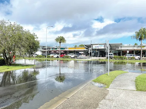


.jpg)


