Showing posts with label flooding. Show all posts

Wednesday 29 April 2015

FLOOD WATCH FOR THE NEW SOUTH WALES COASTAL VALLEYS FROM THE QUEENSLAND BORDER TO TAREE FOR THIS FRIDAY AND SATURDAY


IDN36501
Australian Government Bureau of Meteorology New South Wales

FLOOD WATCH FOR THE NEW SOUTH WALES COASTAL VALLEYS FROM THE QUEENSLAND BORDER TO TAREE FOR THIS FRIDAY AND SATURDAY

Issued at 11:52 am EST on Wednesday 29 April 2015
##
Note: This Flood Watch is a "heads up" for possible future flooding along all rivers and creeks within a nominated valley and is NOT a Flood Warning [see note below].
Onshore winds and rain will increase as a trough deepens off the northern NSW coast on Thursday and Friday. Another East Coast Low is expected to form within this trough on Saturday near the QLD border before moving south to be offshore of the Mid North Coast on Sunday. The northern half of the coast (Mid North Coast and Northern Rivers) will receive the heaviest rain with multi-day falls of 150-200mm, locally 350+mm from Wednesday night to Saturday. Friday and Saturday will see the heaviest widespread falls.
At this stage there is a greater than 70% chance of flooding in the following river valleys developing during Friday and Saturday:
1. Tweed River valley - moderate to major flooding
2. Brunswick River valley - moderate to major flooding
3. Richmond and Wilsons River valley - moderate to major flooding
4. Clarence River Valley, including the Orara River - minor to moderate flooding
5. Coffs Harbour - minor to moderate flooding
6. Bellinger and Kalang River valley - moderate to major flooding
7. Nambucca River valley - moderate to major flooding
8. Macleay River valley - minor to moderate flooding
9. Hastings River valley - minor to moderate flooding
10. Camden Haven valley - minor to moderate flooding
11. Manning River Valley, including Gloucester - minor to moderate flooding
There is still the possibility of renewed flooding in the Hunter Valley (including the Paterson and Williams Rivers) on Sunday and Monday. This will be reviewed on Thursday based on the latest information.
This Flood Watch means that people living or working along rivers and creeks must monitor the latest weather forecasts and warnings and be ready to move to higher ground should flooding develop. Flood Warnings will be issued if Minor Flood Level is expected to be exceeded at key sites along the main rivers for which the Bureau of Meteorology provides a flood warning service. Across NSW over 70% of Flood Watches are followed by flooding within the catchment.
FloodSafe advice is available at www.ses.nsw.gov.au
For emergency assistance call the SES on telephone number 132 500.
For life threatening emergencies, call 000 immediately.

Weather Forecast:

For the latest weather forecast see www.bom.gov.au/nsw/forecasts/

Next Issue:

This Flood Watch will be renewed by 11am Thursday morning.
For latest rainfall and river level information see www.bom.gov.au/nsw/flood/

Friday 20 March 2015

Potential flood impacts of a second Grafton Bridge


What National Party politicians don’t usually mention when bragging about the plan for a second crossing of the Clarence River at Grafton.


4.1. Potential Adverse Flood Impacts

Flood levels within Grafton and South Grafton are largely dictated by the volume of floodwater overtopping the respective levee systems. Upstream of the existing Grafton Bridge, the Grafton and South Grafton levees extend for approximately 10km before tying into naturally high ground. Due to the long length of these levees, slight changes in flood level within the main Clarence River have the potential to considerably alter the volume of water overtopping the levee, possibly resulting in significant variations in flood level behind the levee systems. This has the potential to adversely affect the populations of Grafton and South Grafton, increasing their flood risk exposure. All upgrade options for an additional crossing of the Clarence will increase flood levels. Public concern of this was evident through submissions received during community consultation…….

4.7. Flood Risk Considerations

A problem often experienced by communities protected by levees is complacency regards the likelihood and associated consequences of flooding. When a levee is constructed, the frequency of flooding is reduced, resulting in residents forming the option that the levee has eliminated the flood threat completely. This complacency increases the flood risk within leveed communities. Maddocks et al. (2007) reported that the March 2011 flood was predicted to overtop the levees in Grafton and consequently an attempt was made to evacuate some 12,000 residents. The evacuation was unsuccessful, with only approximately 10% of the people actually evacuating the town. Pfister (2002) stated “the residents of Grafton, having experienced few direct effects of flooding since the construction of the levees, are likely to have developed a low consciousness of the flood threat, and are therefore less ready to act.” Consequently, it appears that although a high levee will provide a high level of protection, it is likely to also induce a high level of community complacency, and when the levee does finally overtop evacuation procedures can be severely hampered and consequences of flooding may be amplified. Community flood education is therefore critical in leveed towns. Flood education aims to increase flood awareness. In times of flood, a flood aware community will be more likely to respond appropriately during an emergency situation. As such, community flood education is an effective means of reducing flood hazard……

4.9. Land Use Controls

…..There is an area that sits outside of the levee system on Carrs Island. Properties on Carrs Island were impacted by Council’s recent upgrading of the South Grafton levee system. As a result, Council has paid to lift several dwelling to place the floor level above the 100yr ARI flood level, as well as building some flood mounds for stock. As such, consideration also needs to be given to the fact that with raising the levee wall, properties sitting just outside of this system have greater impacts during floods. If upgrade of the Grafton and South Grafton levees is proposed as part of the bridge duplication project, further consideration of mitigation measures for the residents of Carrs Island will be necessary……

5. SUMMARY

Roads and Maritime Services (RMS) is currently investigating options for an additional crossing of the Clarence River at Grafton. Without mitigation an additional crossing of the Clarence River will increase upstream flood levels, with adverse impacts to the communities of Grafton and South. RMS intends to maintain the current level of immunity and mitigate any adverse impact from piers and structures within the Clarence River by raising current levees. Although the primary objective of the additional crossing aims to address short-term and long-term transport needs, secondary flood risk management benefits will be an outcome of the project. The additional crossing will significantly improve the flood evacuation situation in Grafton. Furthermore, potential opportunities exist to further reduce flood risk within the respective townships as part of the levee raising exercise which is proposed to mitigate the flood impacts associated with the bridge design. These issues are currently being considered as part of the design process.

I’m sure there are more than a few long time Grafton residents who are hoping that the Baird Government gets the new bridge design right if they do go ahead with construction.

Just as many residents upstream from Grafton are probably hoping that upgraded levees protecting the city don't cause a bottleneck which spreads flooding across their land and, downstream residents hoping this upgrade doesn't funnel more fast moving flood waters towards their towns, villages and farms.

While Clarence Valley Council in its turn is probably hoping that the "good faith" defence in Local Government Act 1993 will cover it should any of the poorly maintained sections of its levee network give way under the pressure of any change in flood behaviour.

Wednesday 18 March 2015

And then he blocked me.....


On 16 March 2015 North Coast Voices posted The flood next time…. which looked at the issue of flood levees in the Clarence Valley that had sections that were in poor or very poor condition.

The post carried photographs of the Wilton Park, Waterview levee such as this:


This is the exchange on the subject which ended with Clarence Valley Council Mayor Richie Williamson blocking North Coast Voices’ tweets:


So I had a big grin on my face yesterday as I listened to this very same mayor (relying on the same facts as the North Coast Voices post) supporting a notice of motion that sought a report to councillors on the condition of its flood levees and, heard him admit the public safety issue and commit council to repair the damaged Waterview levee ahead of any NSW Government monetary compensation for this repair.

The grin grew even broader as I heard him address some of his remarks directly to local mainstream media.


UPDATE

Apparently breakfast announcer with Radio 2GF Grafton, NSW Nationals party member (and campaign manager for Nats MP for Clarence Chris Gulaptis), Clarence Valley Mayor Richie Williamson, who characterizes his Twitter account thus;


has taken exception to North Coast Voices yet again;


Apparently official contributors to North Coast Voices (all of whom are Clarence Valley electors) are something to defecate on for this particular mayor.

For a local government councillor, who has been in office for ten years, it seems that à la Animal Farm some electors  are definitely more equal than others.

An impressive own goal for a mayor hoping to be re-elected in around 541 days. 

Monday 16 March 2015

The flood next time......


Clarence Valley Council (CVC), in the NSW Northern Rivers region, has control of:

110 km of levee 
18 km rock protection 
50 bridges 
500 floodgates 
250 flood mitigation drains

on the Clarence Valley flood plain.

In the 2013 flood one section of the 110km of levee walls was topped at Wilton Park, Waterview:


This is what that section looks like today:

Clarence Valley Council has apparently done no actual repair work on this levee since the 2013 flood.

According to its records it is quibbling over the amount of funding for levee repair the NSW Baird Government is willing to supply:

[CVC Corporate, Governance & Works Committee , Business Paper, 10 March 2015]

One has to wonder what other sections of the levee network are in a similar state of disrepair?

I hope council’s insurer will be happy to pay the costs which are likely to be awarded after the next big flood should residents (and their insurers) take council to court on the basis that levee disrepair contributed significantly to flood damage on their properties. 

Or will council’s insurer refuse to pay if residents were to win such a case?

* All images found on Twitter


UPDATE

Clarence Valley Council rates its infrastructure assets on a scale of 1 (excellent condition) to 5 (very poor condition).

Currently 39 segments of the 110km of levee walls are rated in poor condition to very poor condition.


Floods over recent years have had a major impact on floodplain asset condition. In general the restoration cost of these assets has been excluded from the assessment on the basis that Council will receive Natural Disaster Relief Assistance for damage caused by these events. However, damage will occur to assets from repeated flood events that may not be able to be attributed to single events but will cause the increased deterioration of assets over time. The restoration costs of these assets will ultimately be borne by Council.

Major emphasis is to increase maintenance levels in the following areas:
* Rural levee maintenance – increased inspection and maintenance on a four year cycle;…

Proposed to increase asset renewals and new and upgrading of assets in the following major areas:
* Rehabilitate levee segments rated condition 4 or 5 over a 20 year timeframe (currently 39 segments);….

General focus will be on managing condition 4 and 5 floodplain assets and maintaining floodplain assets rated at condition 3 and above.
*Additional detailed data is to be gathered on floodplain network, especially rural levees, to better determine the extent of the condition of the assets and to more effectively schedule maintenance and capital works. This is also to include crest surveys of the levees.....

Saturday 19 April 2014

When South East Queensland Floods.......


The Dogs Swam Out The Window

The rain came down for weeks on end
We thought it would never stop
The river was over, the road was gone
Under a lake of flood
When the water came in and we had to move
To somewhere on higher ground
A friend offered a hand and the whole town accepted
With kit and belongings in tow
Before we left in the dinghy stacked high
We secured the dogs in the shed on the hill
And hoped they be safe there and dry
The whole district huddled
In one little house on the highest hill
And we sat there all looking out
As the rain just kept coming for days and days still
And the water crept slowly up this our last hill
As you can imagine an Ark was discussed
Children just played in the onrushing gush
Oblivious to worries that had their elders flushed
And as the water lapped the verandah
And we thought swimming, our last dance
The clouds suddenly parted
The storms broke just by chance
And the dogs swam out the window

Reprinted with the kind permission of Vincent J Wight

Friday 20 September 2013

Coal Seam Gas: an object lesson for Northern Rivers communities is coming out of Colorado USA


These photographs and videos set out below are coming out of Colorado in the United States and, show just part of the gas and oil fields flooded in September 2013.

Is this the level of risk Prime Minister Tony Abbott, NSW Premier Barry O’Farrell, Metgasco Limited, and its main backer ERM Power, are willing to expose the flood-prone Northern Rivers region to?


Colorado frack-site flooding - September 2013 from Mateo Albaricoque on Vimeo.
http://vimeo.com/74683562

The Daily Examiner 19 September 2013:

So Metgasco is heartened by what the Liberal/Nationals governments are saying at state and federal level and plans to "ride a rising tide" to corporate prosperity on the backs of local communities.
Perhaps its board members should give some thought to both past and recent North Coast flood event history.
Then look at those news photographs of literally one thousand plus flooded gas wells, miles of broken pipelines, drifting condensate tanks and floating chemical barrels contaminating Colorado countryside right now.
Of which one Weld County, Colorado resident stated in the media:
“We probably shouldn’t have had the oil and gas development in a flood plain to begin with. That would have been the prudent thing. But, it’s done now. Now we have deal with the result of having made that decision.”
I can assure Metgasco that Northern Rivers residents are noting the lessons those photographs teach.

Monday 22 July 2013

It's official. Clarence Valley Council is mad as a march hare


The Daily Examiner 20 July 2013:

Clarence Valley councillor Andrew Baker says he resigned from the environment economic and planning committee in part due to the lack of action in Maclean.
Cr Baker said he was frustrated with, what he termed inaction on plans to link Maclean back to the Clarence River.
The 2011 Clouston plan was widely rejected by the public, Cr Baker said.
The plan was reworked and in June 2012 was adopted by the council, along with a resolution to do "a comprehensive design process for McLachlan Park in 2012/2013, taking into account community views and land tenure considerations".
Cr Baker attended the meeting run by Mr Engwicht, which he said had nothing to do with the design.
He also objected to Mr Engwicht's idea of a "tourist attraction toilet".
"The idea of having a tourist attraction toilet with a secret garden atop to create a secret river experience can only be described as 'on the nose' by anyone who just wants this horrible joke to go away," Cr Baker said.
"It stinks that we would waste ratepayers' money paying someone who wants to hide the river behind the dunny.
"I want Maclean to be thought of as penthouse-quality, not as an outhouse joke."  

All sides in this council debate from the penthouse-quality to the loo with a view have missed the point. 

McLachlan Park is only a name. The reality is that the area in question is a concrete and earthen levee wall of approx. 7,796m2, part of a longer earth wall constructed to protect Maclean against flooding.

It is much more important to ensure the structural integrity of this levee than to tart it up for tourists or remove part of it to provide more CBD parking.

Especially when council management has encouraged councillors to use this 62 year-old high school dropout with no design or planning qualifications (pictured below) as a consultant.

David Engwicht
A relentless self-promoter

* Photographs from PPS and Engwicht website

Monday 11 March 2013

Clarence Valley Mayor Richie Williamson gets a slap down for 'defeatism'


Letter to the Editor, The Daily Examiner 5 March 2013:

Stronger stuff

For the past two Sundays, I have listened to ABC News Radio and I have heard two very different mayoral reactions to multiple flooding events in their respective council areas.

The first was our own Mr Williamson who told the nation, before we had even seen the peak, that The Clarence Valley was "on its knees".

The second, whose name escaped me, has responsibility for Dalby and its surrounds. He said that while Mother Nature was giving it to them, his people "just kept coming back with more".

I appreciate that you were angling for federal and state flood funding for our Valley Mr Williamson but, personally, I believe the Clarence Valley will only be on its knees after the rest of Australia is on its face, dead.

DI Gilks

Saturday 2 March 2013

Labor MP Janelle Saffin seeks federal flood mitigation funding for NSW North Coast

                                   
Wednesday, February 13, 2013.
REF: PE.13.02.13.

The Honourable Bill Shorten MP
Federal Minister for Financial Services and Superannuation
Federal Minister for Employment and Workplace Relations
Suite M1 48
Parliament House
CANBERRA  ACT  2600.

Dear Bill,

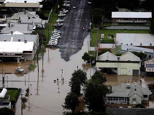
With local communities in Northern New South Wales and Queensland recovering from the human misery and financial costs of record flooding, I write to raise some key policy and funding issues as you continue your leadership in the area of insurance and natural disasters.

Parts of regional Australia certainly have been hit by more frequent floods, bushfires and cyclonic storms in recent years, and with more awareness of climate change, perhaps we do need new pro-active frameworks for dealing with this reality, as per our conversation recently.

I am aware you have advanced options and that these are under consideration with the Insurance Council of Australia.

The Member for Hinkler, Paul Neville, gave a wonderful account of the Bundaberg floods, and while we had already discussed the idea of a bipartisan commitment to flood mitigation which I had intended to detail in my speech, Mr Neville did it so elegantly, I simply supported him.

Such a scheme would involve ‘doing many Granthams’ across Australia – relocating flood-prone homes or raising them out of flood, and levees being built – over the next 10 years.

I have said that it does need to be Federal, State and local government in a combined effort. One policy tool I have talked about in Parliament before is the use of no-interest loans for infrastructure, such as New South Wales has. Perhaps a system of interest rate subsidies for infrastructure by local government may achieve a similar outcome.

The Clarence River peaked as a flood of record at 8.08 metres with a 17-kilometre levee bank system just holding, mainly due to State Emergency Services and Clarence Valley Council sandbagging 300 metres of vulnerable sink hole areas around Dovedale.

In fact, there is local debate over whether the Grafton levee was breached in Fry Street.

This particular flood was fast and furious, and upstream at Copmanhurst and Upper Copmanhurst some families lost everything as several metres of floodwaters inundated their homes or rural properties.

The Governor-General, Her Excellency Quentin Bryce, AC, CVO, and I met with these folk when she made a Vice-Regal visit to the Grafton area on February 1. I know that her presence lifted the spirits of many locals that day.

Bill, I would like to formally invite you to visit the Clarence Valley to take a firsthand look at issues of concern which families, businesses and farmers have been raising with me in the wake of our latest natural disaster.

This flood also breached the levee bank at Ulmarra (Cowper electorate next door to me) and caused major flooding in the village of Brushgrove and small town of Lawrence in my electorate of Page.

It was also the dirtiest flood in living memory with a massive amount of flood debris washed down to places like Brushgrove and on to the popular surfing beaches of Yamba.

Local residents tell me they can live with a major flood every five years or so, but to experience three such events in the past four years is enough to test the will and endurance of the hardiest soul.

This is why the Brushgrove/Cowper Levee Action Committee is renewing its campaign for a 1:20 year flood levee to protect the village, at an estimated cost of about $3 million and built in stages, if need be. It is a matter that has been before the Clarence Valley Council and the former Maclean Shire Council for some time

Committee Secretary Kay Spurr, who holds Masters Degrees in Public Administration and Writing, has provided me with a study of the physical and mental health impact of a flood event on Brushgrove and an assessment of the social benefits of a 1:20 year flood levee.

Brushgrove pensioner Bruce Hancock emailed me on February 8 from ‘Mud Central’ about how insurance companies either will not issue flood insurance policies or charge huge premiums for same in the 2460 postcode area. His is a story repeated across the Clarence Valley.

I know it as well in my hometown of Lismore, where people are priced out of the market, therefore in effect there is no market to serve our needs.

Mr Hancock cited a recent report in The Daily Examiner newspaper of a man whose premium went up by 1010 per cent in one year. In Mr Hancock’s case, his own premium rose by $800 after the 2011 floods and another $600 a year, taking his monthly payment to $293.

Mr Hancock also says that now is the time to look at the concept of a National Disaster Insurance Scheme which would take over the flood/fire/cyclone liability of the insurance industry. I understand his feelings on this completely, but the pressure needs to continue on the ICA to deal fairly on this matter and to operate a super market, and to not price us out of the market.

Mr Hancock points to the New Zealand experience, where a scheme originally set up to cover war damage in the 1940s, now covers damage cause by earthquake, flood and volcanic eruption. I have visited New Zealand and had a firsthand look at their insurance schemes and the no fault as well.

It is, of course, easier in one small jurisdiction to have such a scheme work. I am more focused on moving the mitigation scheme forward, as I see that it has potential to work and work well.

The other issue is that of the opt out clause. It is time to reconsider this, as whilst some insurers have done it regarding floods – some have not and furthermore they are saying if you do not have the flood coverage, we will not cover you at all.  Again leaving no market for the people.

The Australian Government and state governments have Natural Disaster Relief and Recovery Arrangements in place, and we have the Australian Government Disaster Relief Payment, which I was able to secure for the Clarence Valley Local Government Area as a special case.

While these different categories or levels of assistance provide a helping hand to many Australians, one anomaly is that some people experiencing hardship and stress can miss out on emergency assistance because their individual circumstances might not meet strict eligibility criteria as it is applied.

One way of overcoming this, and of making the entire system more cost effective, could be to quarantine a decent pool of national emergency management funding to upgrade and strengthen older flood levees, build new ones, or to raise or relocate homes out of flood.

State governments could make contributions to flood mitigation infrastructure, leveraging off a national fund, as required, and have local government factored in as well.

The Insurance Council of Australia’s chief spokesman Campbell Fuller is on record (SMH Weekend Business February 2-3) as encouraging a pro-active approach to properly built and properly maintained flood levees in order to reduce the cost of insurance premiums. He did not offer assistance though, which would also be welcome.

I look forward to your reply.

Yours sincerely,
Janelle Saffin MP
Federal Member for Page.

Friday, March 1, 2013.
REF: PE.01.03.12.

The Honourable Bill Shorten MP
Federal Minister for Financial Services and Superannuation
Suite M1 48
Parliament House
CANBERRA  ACT  2600.

Dear Bill,

I write to congratulate you on the Australian Government’s new National Affordability Insurance Initiative which you announced in Queensland yesterday, and note there appears to be some $33 million as yet unallocated for flood mitigation projects nationally.

I want to ensure that my electorate of Page receives its fair share of this funding, starting with urgent projects like a 1-in-20-year flood levee for the village of Brushgrove in the Clarence Valley, which I alerted you to in recent correspondence. This long overdue project is estimated to cost about $3 million.

The Northern Rivers has always been an area prone to flooding, but during recent years there has been a dramatic increase in the frequency of these events and the ensuing damage bills. I will seek talks with our local councils and chambers of commerce on compiling a list of fully costed flood mitigation projects which could be considered by the National Insurance Affordability Council.

As you know, I successfully lobbied to have the Australian Government Disaster Recovery Payment activated for the Clarence Valley Local Government Area to provide flood aid after January’s record flood event. Centrelink has processed more than $11 million in these cash payments, helping hundreds of residents who could not access emergency welfare assistance.

I also thank you for keeping under consideration my invitation to visit Brushgrove and other parts of the electorate to see firsthand the potential benefits of new levees or reinforcing existing levees, and the great flood recovery effort by Federal, State and local agencies.

Yours sincerely,

Janelle Saffin MP
Federal Member for Page.

Sunday 24 February 2013

Clarence River Flooding January-February 2013


By now almost everyone in Australia will have seen at least two recent photographs of towns and villages nestled along the NSW North Coast's Clarence River and its tributaries - it has been hard to miss those January and February flood images on the nightly television news and in the online media.

This is yet another perspective captured at 4.30pm on Sunday 24 February.


Click on graphs to enlarge

Real time data for other NSW rivers can be found here.

Wednesday 30 January 2013

Motherly devotion during the January 2013 Australian east coast floods

 
Mother helping winch her child out of a partially submerged ute caught in floodwaters
 
Cows taking their calves to the nearest high ground
 
Spider piggybacking her young to dry land

Click on images to enlarge
All photographs found at Google Image

Saturday 21 April 2012

Daily Examiner goes all coy on name of Maclean Chamber of Commerce 'spokesperson' who actually said this......


The Daily Examiner on 17th April 2011:
“The chamber will argue the Fisheries must be relocated to a more appropriate location with the levee wall in the central business district also moved and replaced with open gates so as to not impede the views.”
Yep, screw with a reliable levee. Just the thing to bring regular visitors into town – the threat of a flood easily breaching CBD defences.
And I’m sure locals in low-lying houses will be thrilled at the thought of the extra risk and maybe less time to evacuate to higher ground.
What did the study named by the journo actually warn about?

Monday 16 April 2012

Developer's dream goes west in Yamba?


For years longtime Yamba residents have pondered the possibility that the ill-advised release of a large section of flood storage land for future urban development would be a graveyard for the speculative developers who currently own this land.

In 2012 they are perhaps seeing the first cracks in the Clarence Valley Council-NSW Government grand plan to eventually place over 2,000 new residents in flood prone West Yamba – with Lot 8 DP1062514 apparently coming onto the market in a forced sale.

This lot is subject to Stage Two of the Yamba By-Pass Road construction. Stage One is currently being progressed by Council.

22 Carrs Drive, YAMBA NSW 2464

Receiver Sale - Residential Subdivision - Yamba

- Potential for 172 lots
- 17.66* ha majority zoned residential (2C)
- 300 metres* to town centre and close to famous surfing beaches
For Sale by Offers to Purchase Closing Thursday 24 May, 2012 at 4pm

Extracted from ASIC's database at AEST 07:21:44 on 15/04/2012

Name EAST COAST PTY LTD
ACN 074 704 028
ABN 91 074 704 028
Type Australian Proprietary Company, Limited By Shares
Registration Date 03/07/1996
Next Review Date 03/07/2012
Status ** UNDER EXTERNAL ADMINISTRATION and/or CONTROLLER APPOINTED **
Locality of Registered Office Yamba NSW 2464
Jurisdiction Australian Securities & Investments Commission

Date Number Pages Description
13/03/2012 7E4331310 11 5011B Copy of Minutes of Meeting of Members, Creditors, Contributories or Committee of Inspection Under S.436e Or S.439a

Sunday 5 February 2012

Australian east coast flooding in pictures, January-February 2012


From Queensland through to News South Wales and Victoria -  La Niña flood waters were a problem to overcome.

Snapshots of Mitchell, Wee Waa, Moree, Belligen, Canungra Creek, Charleville, Coffs Harbour, Charlton and Lawrence........................


Photographs from ABC News files, SBS News, The Australian, The Age, and Goggle Images.