Showing posts with label Australian Bureau of Meteorology. Show all posts

Sunday 23 October 2022

It appears that the rot set in at the Bureau of Meteorology within a few months of Scott Morrison becoming prime minister and sadly when BOM was needed most it is alleged in had become highly dysfunctional


There absolutely needs to be a royal commission into what happened at Lismore. I saw grad mets barely off course in charge of things they would never have been in charge of up until that point. Lismore happened right in the short-staffing period. We go into that event, everyone is already fatigued and working long hours.” [The Saturday Paper, 22 October 2022]


The Saturday Paper, 22 October 2022:


The workplace culture at the Bureau of Meteorology is so toxic that a man was hospitalised twice for psychiatric care, another had a heart attack while working extreme overtime, and was asked to come back earlier than a doctor advised, and at least five more staff took stress leave because of panic attacks and anxiety regarding management oversight.


More than 20 staff have left the media and communications division at the BoM in the past 18 months. The entire marketing team at the agency was “bloodlet” and removed during a restructure and rebranding effort that consumed the time and resources of the weather office during a period of intensifying calamity relating to climate change and natural disasters. Senior meteorologists have also left.


Since June last year, the bureau has spent more than $260,000 with Elm Communications Canberra Pty Ltd, just trying to plug gaps in its public affairs workforce.


Although many of the concerns relate to the media division, meteorologists and other staff have complained of “the severe dysfunction” in this area infecting other parts of the service. Gag orders have been issued to prevent forecasters from speaking to journalists unless their comments are pre-approved. Media managers have explicitly banned the mention of climate change in connection with severe weather events.


In one case during major New South Wales flooding in March last year, an edict was issued that BoM forecasters and other specialists were not to speak to any media after a meteorologist was accused of “fluffing” his lines on climate change.


A spokesperson for the BoM denies this.


In addition to the above concerns, The Saturday Paper can reveal the Commonwealth agency admitted some months ago to staff that it has not been paying overtime correctly and has so far failed to reimburse employees. Indeed, it stopped communicating with them in August about the issue.


The bureau says, in a response to The Saturday Paper, that a “discrepancy” was identified and “an audit of overtime payments is currently under way and all payments made dating from 1 June 2021 are being reviewed”.


The Saturday Paper has spoken with 20 current and former staff members at the bureau to establish a distressing and farcial account of a government agency’s response to a changing climate.


Details in this account that do not appear within quotation marks have nevertheless been provided by individuals who spoke on the condition of anonymity, fearing reprisals…..


There is so much focus on rebranding efforts like this and all of this window dressing and, in the meantime, the staff are really struggling to get the work done. We have lost so many people due to the [public service] transition to national production.”


Under these reforms, which began after the appointment of Andrew Johnson as director of the BoM, regional forecasting centres in every state and territory have been shuttered. State managers have been sacked and a national desk has been created instead. Johnson has pushed the project with fervour. The new branding, complete with public insistence that the Bureau of Meteorology be referred to respectfully as the Bureau, was, according to sources at the BoM, “completely driven by him”……


The Saturday Paper can reveal that the planned name change and new “corporate presence” began more than three years ago and cost far more than has been reported. In December 2018, the BoM paid almost $90,000 to brand specialists The Contenders for work on the new “positioning project” between then and April 2019. When a new general manager of communications – Emma Liepa – took over in April 2020, she “canned the project” and restarted it using her preferred contractor, The C Word Communications Agency Pty Ltd, owned and operated by Jack Walden. The BoM has characterised this contract as a “preliminary analysis” of perceptions about the agency and its “position in the marketplace” and not part of the “Brand project”.


Walden’s The C Word agency won a $70,000 contract in September last year in a “limited tender” to progress this project. Walden is now a senior manager of communications delivery at the BoM, having started in late November last year.


The Saturday Paper understands that Walden was hired as an EL2 “upper”, the same pay band as his boss Liepa, and is an ongoing public service employee. Walden also worked with Liepa in her previous role at the Victorian Healthcare Association. The Saturday Paper is not suggesting there is anything inappropriate in his employment.


In this case, a conflict of interest was advised,” a BoM spokesperson said.


There was no overlap between the work as a consultant and work when he [Walden] commenced as an employee with the Bureau.”


Internally, the rebranding has been prosecuted with fervour by Liepa and her colleagues but resisted and mocked by more junior staff. This is at odds with a BoM statement that says the sentiment, and feedback, from employees has been “overwhelmingly positive”.


Recently Andrew Johnson launched the new 2022-2027 strategy and rounded off the presentation by telling us all that we had to print off the strategy, read it and he would be testing us if he bumped into us in the office,” a staff member says. “He was dead serious.”


A forecaster who cannot be identified because they still work with the BoM said the “reaction around me on shift over the last few weeks to the new branding announcements has been somewhere between exasperated laughter and anger”.


They continue, “That this is prioritised by management, over severe long-term understaffing of mets [meteorologists] – seemingly not of management and consultants – combined with a huge top-to-bottom restructure of the public service hitting the really hairy stages.


All of this at the tail end of three La Niñas in a row with the potential for most of the east coast to flood so easily. Meteorologists are tired and overworked. The public reaction today was honestly wonderful and heartwarming. I’m so happy the public saw the bullshit instantly.”


Neither Environment Minister Tanya Plibersek, whose portfolio includes the BoM, nor her office, was aware the agency was about to launch its controversial edict and new look publicly in the middle of a flooding crisis across Victoria. When she demanded an urgent briefing, the response from senior bureau managers was “cagey” and “unsatisfactory”, according to people familiar with the exchange. Internally, BoM staff were told that they were to move full steam ahead and that the minister’s office was happy.


But what the minister’s office did not know, because the BoM did not tell them, was that the full cost of this rebranding was closer to $750,000, with some of that cost completely unnecessary after the banishing of The Contenders and early work done by that firm.


When Plibersek’s people demanded a full list of contracts, this was not mentioned. The Saturday Paper has confirmed this separately using information provided by concerned employees. Bizarrely, the BoM hired EY Sweeney on a $93,000 contract in March to conduct market research regarding the rebrand. What the consultants found was that just 15 per cent of people recognised the Bureau of Meteorology as “the Bureau” – the preferred name for brand recognition in the now-failed repositioning. More than 60 per cent, however, associated “BoM” with the agency.


What matters, according to every staff member who spoke for this piece, is that this side quest isn’t just a bad look. While these dramatic restructures and fiddly public relations exercises unfolded, some of the worst flooding in Australian history happened in northern NSW.


Residents in Lismore in particular were trapped after catastrophic flooding appeared to catch officials off guard. While the SES, itself struggling with a new centralisation plan, is responsible for issuing evacuation orders, they rely on information from the national meteorologists and hydrologists at the bureau.


The BoM went into this PST [Public Sector Transformation] understaffed, and only lost countless more staff during PST, not realising that not everyone wants to uproot their lives and move to Melbourne or Brisbane,” a meteorologist said.


There absolutely needs to be a royal commission into what happened at Lismore. I saw grad mets barely off course in charge of things they would never have been in charge of up until that point. Lismore happened right in the short-staffing period. We go into that event, everyone is already fatigued and working long hours.”


At this time – when a meteorologist was due to speak at a press conference about the unfolding flooding emergency in NSW, next to Premier Dominic Perrottet – there was a particular sensitivity within the agency about the warnings provided to the public. This forecaster was told they could speak only from pre-approved lines.


A separate source, who is no longer with the BoM, told The Saturday Paper that the organisation was “down 24 or 25” meteorologists and there were “no meteorologists in management”. The source said good people were slowly forced out, especially meteorologists: “There is such a strangled culture there now.”


After being appointed by the former Coalition government to head the BoM, Johnson set about an aggressive reform program, parts of which former employees concede were much needed. But it happened so fast it caused serious issues across the business.


The rate of change, ineffective change, that has happened has been a huge problem because there are so many conflicting priorities, that the bureau basically just ground to a halt,” a source says.


All the money just got funnelled into [PST] and squandered through massive use of contractors and people who didn’t have core knowledge of the bureau, so it took lots of time to ramp up to speed and the like.


Really important projects like ours just got buried and not funded because all the money just got funnelled off into these other areas.”


One of the projects that was delayed and underfunded was the upgrade of the bureau’s warning systems – a multi-part program with many moving parts – which was left in disarray.


As science was censored or relegated to the sideline and messages became more tightly controlled, the culture at the BoM deteriorated even further. In July and August this year, tens of thousands of dollars were paid to the conflict resolution firm Momentum, which promised to mediate workplace disputes and teach staff how to get along…….


The full article can read here.


Thursday 20 October 2022

How in late 2021 then Prime Minister #ScottyFromMarketing Morrison spent $220,296 his government couldn't afford on a BOM logo change & creating 9 new Twitter handles


Over four months since the nation rejected the Morrison Coalition Government, sending is members to the Opposition benches, the poor decisions of then prime minister Scott Morrison and his cabinet ministers are still coming to light. 

In this case Morrison was helped along by his then minister for the environment Sussan Ley, now ensconced as Deputy Leader of the Opposition and probably hoping no-one remembers that the Australian Bureau of Meteorology (BOM) was in her ministerial portfolio when this downright silly decision was made.


The Guardian, 19 October 2022:

Revealed: BoM rebranding and logo cost $220,000 as Plibersek shoots down weather bureau’s name change

The environment minister, Tanya Plibersek, has shot down the Bureau of Meteorology’s request for people not to call it “the BoM”, saying Australians should be free to call it whatever they like as the full cost of the rebrand has been revealed.


The BoM rebrand cost more than $220,000, including cash to update the organisation’s visual style and logo, conduct research, develop pull-up banners and support media engagement.


My focus and the focus of the BoM should be on weather, not branding,” Plibersek said on Wednesday.


On Tuesday, the agency formerly known as the BoM asked media organisations to only refer to it by its full name, or shorthand as “the Bureau” – not the widely used initialism BoM. The media-wide alert sparked derision online after it was discovered that the Bureau appeared to have failed to reserve the Twitter accounts it had announced it planned to move to.


The letters BOM seen over a satellite view outline of Australia


Guardian Australia understands the change, detailed in an email bearing a new bureau logo, was part of a wider rebrand that commenced under the previous Coalition government and had been under way for some 18 months.


It was reported yesterday that a $69,300 contract had been awarded in September 2021 to Melbourne’s C Word Communications Agency for “branding of product naming services” and “brand implementation”.


The full cost of the rebranding exercise was $220,296.


Plibersek’s office said The C Word’s contract covered “communication and implementation planning support”. Another $118,177 was awarded to another agency, Era-Co, for brand strategy and design services, including visual style, brand position and logo, as well as research.


Another $32,819 was spent on “implementation costs” for the rebrand, including development of pull-up banners to support community engagement and media engagement for each state and territory, as well as design support to update collateral, systems and tools.


Era-Co was granted a $50,000 contract for “brand framework” for the Bureau of Meteorology, according to a notice published on the AusTender website in September 2020; then another $80,000 contract for “visual identity development”, according to a notice published in December 2020; and $17,820 for “design services”, in a notice published in August 2021.


The C Word’s $69,3000 contract for “brand implementation” was published September 2021.


I have asked for the information about the full cost of the whole rebrand project, which was undertaken under the previous government,” Plibersek said.


I’ve released that publicly. Now it’s time to let the Bureau of Meteorology get on with what it does best – predict the weather to help keep Australians safe.”


The environment minister said on Tuesday she did not “quite understand” why the bureau commenced a rebrand to update its name and logo, saying she was not focused on those factors during the severe flooding across much of the eastern seaboard. On Wednesday she appeared to rebuff the bureau’s calls to be referred to by another name.


The Bureau of Meteorology, the BoM – Australians will make up their own minds about what they call it,” Plibersek said.


What matters is accurate and timely weather information for communities, particularly during severe weather like we’re experiencing right now. That’s where my focus is. People are hurting.”…...


Several new Twitter handles proposed by the bureau, including @TheBureau_NSW and @TheBureau_AU, were quickly snapped up by ordinary users on Tuesday. A Bureau spokesperson said on Tuesday it was “working closely with Twitter to rectify this, in the meantime, all existing BOM Twitter handles remain active”.


By Wednesday, all those accounts were either suspended or free to use, having been vacated by the users who had parked on those handles…... [my yellow highlighting]


The Guardian, 18 October 2022:


The name change – which has been broadly ridiculed, and criticised for its rollout as many Australians face devastating floods – was, in part, driven by Jack Walden, according to insiders. Walden appears to have won the contract for the consultancy company, and been hired by the Bureau shortly afterwards.


In September 2021, the Bureau awarded a $69,300 contract to the C Word Communications Agency for “branding of product naming services and “brand implementation”.


C Word’s “chief communicator” until December 2021 was Jack Walden.


According to his LinkedIn profile, Walden started as senior manager, communications delivery at the Bureau in November 2021. The crossover in his employment dates has not been explained.


Guardian Australia understands the rebrand was broadly unpopular among existing staff, but that the Bureau insisted that not only it be implemented, but that staff only use the new terms.


One insider said they were made to use the new term, and another said they were treated “like naughty schoolchildren” if they slipped up and referred to the BoM instead.


Plibersek told Guardian Australia that “during this time of severe weather and flood disaster, I’m not focused on the name of the agency”.


I am focused on making sure the Bureau of Meteorology is providing the most accurate and timely information to communities affected by floods,” she said.


The rebrand commenced under the previous government for reasons I don’t quite understand.”……


~~~~~~~~~~~~~~~~~~~

~~~~~~~~~~~~~~~~~~~


UPDATE:

By late afternoon on Thursday 20 October 2022, the Bureau of Meteorology (BOM) had walked back on its rebranding demands.


The Bureau of Meteorology has backed down on its planned rebranding, saying people can still refer to the weather agency as “the BoM” – or anything else they like. The backflip follows the BoM’s announcement on Tuesday that it wanted media agencies to refer to it as “the Bureau” or its full name rather than “BoM”.....
following the subsequent public outcry and ridicule over the mooted move, the organisation said it would now stick with the BoM moniker. “The community is welcome to refer to the Bureau in any way they wish, including referring to us as the BoM,” the spokesperson said.

Thursday 15 September 2022

THREAT OF FLOOD REMAINS: a third La Niña event is underway in the Pacific Ocean and communities in eastern Australia should be prepared for above-average rainfall over spring and early summer


 Australian Bureau of Meteorology, media release, 13 September 2022:


La Nina event declared - above average rainfall likely for eastern Australia


The Bureau of Meteorology has declared a La Niña event is underway in the Pacific Ocean and communities in eastern Australia should be prepared for above-average rainfall over spring and early summer.


Bureau of Meteorology head of long-range forecasts, Dr Andrew Watkins, said the Bureau's three-month climate outlook shows a high chance of above average rainfall for most of the eastern half of the Australian mainland and eastern Tasmania.


During La Niña events, waters in the eastern tropical Pacific Ocean are cooler than normal, and waters in the western tropical Pacific Ocean warmer than normal. This causes changes in wind, cloud and pressure patterns over the Pacific. When this change in the atmosphere combines with changes in ocean temperature, it can influence global weather patterns and climate, including increasing rainfall over large parts of Australia”.


Dr Watkins said while La Niña criteria have been met, most models forecast this event to be weak to moderate in strength, likely to peak during spring and ease during summer.


"La Niña is not the only driver influencing this wet outlook. To our west, a significant negative Indian Ocean Dipole (IOD) event is underway. We expect the IOD influence will reduce in late spring or early summer,” Dr Watkins said.


"The Southern Annular Mode (SAM) is also in a positive phase, and likely to remain positive into summer. Positive SAM during summer pushes weather systems south, which increases the chance of rain in New South Wales, eastern Victoria and southern parts of Queensland,” he said.


Dr Watkins said all these climate influences push Australia's climate towards a wetter phase, and together have shaped our outlook for the coming months that shows more than 80 per cent chance of above average rainfall for many parts of the eastern half of Australia.


With catchments already wet, the flood risk remains, particularly for eastern Australia.


The Bureau is encouraging communities to keep up to date with the latest forecasts and warnings on the Bureau's website and BOM Weather app.


For more information about our climate outlook and La Niña visit our website:


2022 marks the third year in a row of La Niña conditions. 

 *

Thursday 18 August 2022

Still no assurances that increased heavy rainfall episodes in south east Australia have gone and 'normal' seasonal weather returned


Unfortunately it appears that north-east NSW can not yet rest easy.....


ABC News, 16 August 2022:


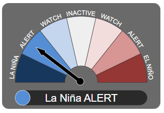
The odds of there being a third sodden summer in a row have shortened now the Bureau of Meteorology has declared a La Niña alert.


Renewed cooling in the tropical Pacific Ocean and models indicating La Niña is likely during spring and early summer have prompted the BOM to raise the El Niño Southern Oscillation Index scale to "alert", the last step before an official La Niña.


Four of seven climate models it surveys suggest La Niña could return by early to mid spring. The remaining three suggest levels will remain neutral but close to the La Niña threshold through to the end of 2022.


If the climate driver is declared, it would be the third consecutive La Niña summer.


Triple-dip La Niñas are relatively rare, having only occurred twice since 1950, in 1973-76 and 1998-2001.


But with catchments already primed and water storages full, the third wet year could signal disaster.


National water storage levels are currently sitting at 71.3 per cent, up 5 per cent on last year, while the Murray-Darling Basin is sitting at 92.2 per cent, up 12.4 per cent on this time last year.


Many dams up and down the east coast are now sitting at or over capacity….


With catchments sodden, it won't take much before the water has nowhere to go…..


This year the rainfall is being further charged by a negative Indian Ocean Dipole (IOD), which has already been declared.


Much like a La Niña, a negative IOD means there is extra moisture available, this time in the north-west.


Frontal systems can then tap into that moisture and drag it across the country, typically bringing wetter than average conditions for south-eastern Australia in winter and spring until the monsoon moves down and breaks up the cycle in early summer.


All La Niñas and IODs are different and there are no guarantees when it comes to forecasting.


But even if the Bureau's official La Niña thresholds are not met this summer, above average sea surface temperatures will likely aid rainfall.


At this point, there is a strong chance of a third La Niña, acting on already primed catchments, with a complementary IOD, which is likely to bring more rounds of flooding rains this spring and summer....


Insurance News, 16 August 2022:


Flood fears increase as likelihood of rare triple-dip La Nina rises


The Bureau of Meteorology has today issued a La Nina alert, meaning there’s now a 70% chance that the flood-inducing climate driver will develop this year.


It would be the third La Nina in a row – something that has only happened twice since 1950 – leading to fears of more heavy rain along the already flood-hit east coast of Australia.....


Australian Bureau of Meteorology, ENSO Outlook An alert system for the El Niño–Southern Oscillation, 16 August 2022:


ENSO Outlook moves to La Niña ALERT


The ENSO Outlook has [moved] to La Niña ALERT. This means that even though the El Niño–Southern Oscillation is currently neutral, the chance of La Niña forming in the coming months has increased to around 70%. This is roughly three times the normal likelihood of an event forming in any year.


This status change follows a renewal of cooling in the tropical Pacific Ocean towards La Niña thresholds over recent weeks, as well as the persistence of the Southern Oscillation Index (SOI) at La Niña levels and strengthened trade winds at La Niña levels. Climate models indicate further cooling is likely, with four of seven models suggesting La Niña could return by early-to-mid southern hemisphere spring.


A La Niña ALERT is not a guarantee that La Niña will occur, rather it is an indication that most of the typical precursors of an event are in place. La Niña conditions increase the chance of above average spring and summer rainfall in northern and eastern Australia.


Bureau climatologists will continue to closely monitor conditions in the tropical Pacific as well as model outlooks for further signs of La Niña re-emergence.


"The chance of a La Niña developing in the coming season has increased. When these criteria have been met in the past, a La Niña event has developed around 70% of the time.".....


La Niña Alert


Any three of the following criteria need to be satisfied:


  • Sea surface temperature: A clear cooling trend has been observed in the NINO3 or NINO3.4 regions of the Pacific Ocean during the past three to six months.

  • Winds: Trade winds have been stronger than average in the western or central equatorial Pacific Ocean during any two of the last three months.

  • SOI: The two-month average SOI is +7 or higher.

  • Models: A majority of surveyed climate models show sustained cooling to at least 0.8 °C below average in the NINO3 or NINO3.4 regions of the Pacific Ocean by the late winter or spring.


Thursday 26 May 2022

Communities in the seven local government areas of the NSW Northern Rivers region know where they have been in 2022 and now they know where they are heading - into more rain


ENSO Outlook
An alert system for the El Niño–Southern Oscillation, 24 May 2022


Australian Bureau of Meteorology:


Special Climate Statement 76 - Extreme rainfall and flooding in south-east Queensland and eastern New South Wales, February-March 2022

25/05/2022 - National


Issued at 10:30am, Wednesday 25 May 2022


The Bureau of Meteorology has released a formal record of the extreme rainfall and flooding that occurred in south-east Queensland and eastern New South Wales in February and March this year.


Special Climate Statement 76 outlines that several rainfall records were broken between 22 February and 9 March 2022, with more than 50 sites recording more than one metre of rainfall in one week.


In the last week of February, parts of south-east Queensland and north-east New South Wales had rainfall 2.5 times their monthly average with some regions recording more than five times their monthly average.


After two years of La Niña conditions, the rain fell on saturated catchments leading to flash and riverine flooding extending from Maryborough in Queensland to Grafton in New South Wales.


For many areas, this was the wettest week since at least 1900. Some areas of south-eastern Queensland had their highest flood peaks since 1893, though the lower Brisbane and Bremer rivers and Lockyer Creek peaked below the levels of both January 1974 and January 2011 floods.


In parts of northern New South Wales, flood levels broke previous records. Wilsons River in Lismore peaked at a record high level, estimated to be 14.4 m on 28 February. The previous record was 12.27 m in February 1954.


The rainfall was the result of a combination of weather systems over eastern Australia and the Tasman Sea, where a large volume of humid tropical air moving onshore over eastern Australia was lifted in the atmosphere to produce heavy rain and thunderstorms.


In recent decades, there has been a trend towards a greater proportion of high-intensity, short-duration rainfall events, especially across northern Australia.


The Bureau's special climate statements provide detailed summaries of significant weather and climate events that impact Australians. This Special Climate Statement has been added to an archive of Special Climate Statements dating back more than 15 years, providing easy access to data and information.


Special Climate Statement 76 can be found here: http://www.bom.gov.au/climate/current/statements


The Guardian, 25 May 2022:


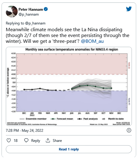
The breakdown of the La Niña weather pattern in the Pacific has stalled while a key Indian Ocean climate driver is tilting towards its wetter phase, making it more likely that eastern Australia will face more heavy rain and floods.


Just as the Bureau of Meteorology released a special climate report on the extreme rainfall and flooding that hit parts of south-eastern Queensland, northern New South Wales and the region around Sydney in February and March, its fortnightly report on climate influences pointed to the big wet extending for months to come.


The La Niña event, already in its second year, could yet persist into a third. The expected dissipation of the pattern has not progressed in the past two weeks, and two of the seven models used by the bureau project that the La Niña will last through winter.


Out west, the Indian Ocean dipole is forecast by all climate models to enter its negative phase in coming months.


That phase of the dipole – which gauges the relative differences of sea-surface temperatures across the ocean – increases the chances of above-average winter-spring rainfall for much of Australia. It also lifts the odds of warmer days and nights for northern Australia, according to the bureau.


The prospect of wetter than normal conditions for the east coast in particular will prompt fears of further floods. Catchments remain damp and dams are full, so it won’t require significant bursts of rain to cause more flash flooding and damage.


Read the full article here.