Showing posts with label La Niña. Show all posts

Wednesday, 15 May 2024

Is this going to be one of the shorter 'neutral' periods in that dance Australia's weather conditions do between El Niño and La Niña climate patterns - approximately 44 days before the pointer swung towards "La Niña Watch"


It appears that Australia has a 50-50 chance of entering a La Niña event in the second half of 2024.


La Niña typically means:

  • Increased rainfall across much of Australia

  • Cooler daytime temperatures (south of the tropics)

  • Warmer overnight temperatures (in the north)

  • Shift in temperature extremes

  • Decreased frost risk

  • Greater tropical cyclone numbers

  • Earlier monsoon onset


According to the Australian Bureau of Meteorology: In eastern Australia, the average December-March rainfall during La Niña years is 20% higher than the long-term average, with eight of the ten wettest such periods occurring during La Niña years. This is particularly notable for the east coast, which tends to be less affected by La Niña during the winter months but can experience severe flooding during La Niña summers.


The record breaking NSW Northern Rivers floods of February-March 2022 occurred in a La Niña event - part of the 'triple dip' La Niña which occurred in 2020-2022.


Australian Bureau of Meteorology (BOM), Climate Driver Update: Climate drivers in the Pacific, Indian and Southern oceans and the Tropics

14 May 2024

SUMMARY


La Niña Watch—some signs of La Niña formation later in 2024

La Niña Watch


The El Niño–Southern Oscillation (ENSO) is currently neutral. There are some early signs that a La Niña might form in the Pacific Ocean later in 2024. As a result, the Bureau's ENSO Outlook has shifted to La Niña Watch. When La Niña Watch criteria have been met in the past, a La Niña event has subsequently developed around 50% of the time. There is about an equal chance of neutral ENSO conditions in the same outlook period.


Sea surface temperatures (SSTs) in the central Pacific have been steadily cooling since December 2023. This surface cooling is supported by a significant amount of sub-surface cooling in the central and eastern Pacific. Recent cloud and surface pressure patterns are ENSO-neutral.


The Bureau's modelling suggests that ENSO will likely remain neutral until at least July 2024. It is important to emphasise that early signs of La Niña are most relevant to the climate of the tropical Pacific, and that the long-range forecast for Australian rainfall and temperature provides better guidance for local climate.


The Indian Ocean Dipole (IOD) is currently neutral. The most recent 2 weeks have seen the IOD index within neutral thresholds, and follow 7 weeks of the index being above the positive IOD threshold (+0.40 °C). The current SST observations suggest that recent development of a positive IOD may have stalled. If a positive IOD eventually develops, it would be earlier in the calendar year than is typical historically.


Global sea surface temperatures (SSTs) have been the warmest on record for each month between April 2023 and April 2024, with April 2024 SSTs warmer than April 2023. The global pattern of warmth is affecting the typical historical global pattern of sea surface temperatures associated with ENSO and IOD variability. As the current global ocean conditions have not been observed before, inferences of how ENSO or IOD may develop in 2024 that are based on past events may not be reliable.


The Southern Annular Mode (SAM) is currently neutral (as at 13 May). Forecasts indicate the index is mostly likely to remain neutral or become positive in the coming fortnight.


The Madden–Julian Oscillation (MJO) is currently weak. Most models forecast indicate that the MJO will remain weak before re-strengthening over the eastern Indian Ocean or Maritime Continent region from mid- to late-May.


Friday, 17 March 2023

La Niña has ended - ENSO now neutral. El Niño WATCH has begun.


Australian Bureau of Meteorology (BOM), Climate Driver Update, media release, 14 March 2023:


Current status: EL NIÑO WATCH


La Niña has ended - ENSO now neutral. El Niño WATCH issued


  • La Niña has ended in the tropical Pacific Ocean. The El Niño–Southern Oscillation (ENSO) is now neutral (neither La Niña nor El Niño) with oceanic and atmospheric indicators having returned to neutral ENSO levels.


  • International climate models suggest neutral ENSO conditions are likely to persist through the southern autumn. However, there are some signs that El Niño could form later in the year. Hence the Bureau has issued an El Niño WATCH. This means there is a 50% chance of an El Niño in 2023.


  • The Madden–Julian Oscillation (MJO) is currently very strong over the Pacific Ocean but is forecast to move into the Atlantic Ocean in the coming fortnight. This may bring drier conditions to Australia for the latter half of March.


  • The Southern Annular Mode (SAM) index is currently strongly negative but is expected to return to neutral values over the coming weeks.


  • Warmer than average sea surface temperatures persist around south-east Australia, New Zealand and the west coast of Australia, but close to average temperatures prevail around northern Australia.


  • The Indian Ocean Dipole (IOD) is neutral – the IOD typically has little influence on Australian climate while the monsoon trough is in the southern hemisphere (typically December to April). Forecasts for the IOD made at this time of the year have low accuracy beyond April.


  • Climate change continues to influence Australian and global climates. Australia's climate has warmed by around 1.47 °C over the period 1910–2021. There has also been a trend towards a greater proportion of rainfall from high intensity short duration rainfall events, especially across northern Australia. Southern Australia has seen a reduction of 10 to 20% in cool season (April–October) rainfall in recent decades.


Saturday, 21 January 2023

Tweet of the Week


Wednesday, 21 December 2022

La Niña continues into the Australian Summer


Australian Bureau of Meteorology, Climate Driver Update, 20 Dec 2022:


  • La Niña continues in the tropical Pacific, but some indicators show signs of declining strength. La Niña typically increases the chance of above average rainfall for northern and eastern Australia during summer. Models suggest that ocean temperatures may reach ENSO-neutral levels during January or February 2023, and remain at neutral levels until at least April. Model accuracy for lead times greater than four months is generally lower at this time of year than at other times, so outlooks beyond April should be viewed with caution.


  • The Indian Ocean Dipole (IOD) is neutral and has little influence on Australian climate while the monsoon trough is in the southern hemisphere (typically December to April).


  • The Southern Annular Mode (SAM) is in a positive phase and is likely to be neutral to positive through January and February. During summer, a positive SAM increases the chance of above average rainfall for parts of eastern Australia and below average rainfall for western Tasmania.


  • The Madden–Julian Oscillation (MJO) is expected to move across the Maritime Continent and Western Pacific regions over the coming fortnight, which may lead to increased westerly flow and rainfall across parts of northern Australia. The influence of the MJO may lead to the onset of the Australian monsoon during this time, while also increasing the risk of tropical low and cyclone formation across the region.


  • Sea surface temperatures remain warmer than average in the western Pacific, much of the Maritime Continent, and around northern Australia, particularly in the Coral Sea. Warmer Australian waters, especially in the tropics, can result in greater evaporation, humidity, cloudiness, and rainfall.


  • Climate change continues to influence Australian and global climates. Australia's climate has warmed by around 1.47 °C in the period 1910–2021. There has also been a trend towards a greater proportion of rainfall from high intensity short duration rainfall events, especially across northern Australia.


Next update expected by 3 January 2022


Monday, 24 October 2022

MONDAY 24 October 2022: this morning in New South Wales


Australian Bureau of Meteorology (BOM), Current Warnings, Monday 24 October 2022


Note: The warning list was valid at 6.35am and is updated by BOM as circumstances changes


Friday, 21 October 2022

No sign of a break in widespread rain across NSW and road damage toll mounts


The Sydney Morning Herald, 20 October 2022:


Holidaymakers heading into regional NSW over the next few months have been told to brace themselves for longer journeys on more dangerous roads after a year of record rain and flooding.


The severe weather has caused billions of dollars in damage to local roads across the state, bringing regional councils to “their knees” as they struggle with repairs, and heaping pressure on the state government to intervene…..


NRMA spokesman Peter Khoury said the damage to roads across the state posed a safety risk heading into the summer and councils needed more state and federal funding to ensure their roads were safe after the rain.


The roads are not great, they are littered with potholes and are severely damaged, but also roadworks will be taking place, which means people will need to slow down for those as well,” he said.


There are safety risks when it comes to roads that are so badly damaged. It is easier to lose control, especially on high-speed roads.


It’s going to be a challenging period and it’s not going to get better until the rain stops.”


The NRMA roadside assistance team was receiving almost twice as many call-outs for tyre and wheel damage in NSW compared with last year.


NSW Farmers fears the state of regional roads will impede the harvest of this year’s winter crops, due to start in NSW in the next few weeks, because heavy vehicles and machinery will struggle to get to farms and then get the crops to market…...


Local Government NSW said some councils were now spending up to 90 per cent of their capital works budgets on road repairs and this year’s rain had caused $2.5-$3 billion worth of damage to local roads.


It reiterated its call for the state government to act on its 2019 election promise and take over 15,000 kilometres of country roads owned and repaired by councils.


A spokesman said the government’s failure to do so had “heaped more pain on many regional and rural councils, who are financially on their knees due to rising repair costs”.


Almost 80 councils have identified 500 roads they want the state government to reclassify or take over. So far, the government has said it will take on five roads – totalling 391 kilometres – identified in a priority audit, but the transfer of ownership will take time. An independent panel is reviewing the remaining nominations……


The Bureau of Meteorology (BOM) expects this current bout of rain to continue falling over the Northern Rivers region at least until Thursday 27 October.


BOM advice as of 19 October 2022 was:


Significant rain and thunderstorms are continuing to spread across eastern and south-eastern Australia and will continue into next week.


Rain and thunderstorms with heavy falls over South Australia and Queensland are due to spread into northern and western New South Wales towards the South Australian and New South Wales border on Wednesday night.


Severe thunderstorms are also likely across Queensland and northern New South Wales, with heavy rainfall leading to flash flooding, damaging winds and large hail. Heavy falls across inland South Australia could also lead to flash flooding.


Thursday will see widespread thunderstorms across eastern Queensland, New South Wales, northern Victoria, and far eastern parts of South Australia, with isolated heavy falls.


Inland Queensland and New South Wales are also likely to see some severe thunderstorms with heavy rain, damaging winds and large hail, with giant hail also possible.


Further rainfall in coming days for southern inland Queensland, on and west of the ranges in New South Wales and northern Victoria is likely to lead to widespread moderate to major flooding impacting already flood affected communities.


On Friday and leading into Saturday widespread showers and thunderstorms will continue for eastern Queensland, New South Wales, Victoria and Tasmania, as humid and unstable conditions persist across eastern and south-eastern Australia.


Severe thunderstorms are likely across eastern Queensland, New South Wales, and parts of Victoria, bringing more large hail, damaging winds, and heavy rainfall.


Severe thunderstorms are likely across eastern Queensland, New South Wales, and parts of Victoria, bringing more large hail, damaging winds, and heavy rainfall.


Widespread rainfall totals of 25 to 50 mm are likely across South Australia, Queensland, New South Wales, and Victoria this week and into the weekend, with 50 to 100 mm falls possible in southern inland Queensland, on and west of the ranges in New South Wales.


This rain and storm activity will lead to renewed river level rises and widespread moderate to major flooding across southern Queensland, inland New South Wales, and possibly northern Victoria…...


For all the latest warnings see National Warnings Summary.


8-DAY TOTAL RAIN FORECAST


Australian Bureau of Meteorology, rain map, issued 7:43am AED Thursday 20 October 2022


Tuesday, 11 October 2022

Road travel is still hazardous in regional & rural NSW after more than 9 months of heavy rainfall & flood damage


ABC NEWS, 9 October 2022.  IMAGE: The swollen Macquarie River continues to rise near homes around Troy Gully in Dubbo.(Supplied: Rod Price)


The Daily Telegraph/Northern Star, 6 October 2022:


Tony Leggo was part of the Bonalbo Rural Fire crew who attended the latest accident where a coupe ended up on its roof.


Two local Bonalbo residents were driving behind them and saw the rear swaybar of the car in front come off in the first set of potholes,” Mr Leggo said.


The car then lost control and hit a second lot of potholes where it started to roll over.


A crew of four as well as the Group Captain West attended that one.”


He said all of the district’s roads are in poor condition after back-to-back La Nina events and associated floods.


I get it,” he said, “but when you’re forced to drive at 60 km/h or less on sections and meet someone on your side of the road coming around corners, it’s dangerous.


Millions were spent recently on a section of the Clarence Way which was improperly mixed so it has to be done again.


The accident should be a wake up call because it was sheer luck nobody died.”…..


Bonalbo firefighter Joanne Leggo was on scene to assist.


In my own opinion, I think that the condition of the road, with many potholes being unavoidable, has taken its toll on our cars and perhaps the car experienced mechanical failure upon hitting the smaller, hard to avoid, potholes,” Ms Leggo said.


They may not have known that the car was at breaking point that day.”


Clarence Way, a major arterial road that connects NSW and Qld, demands improvement, according to residents and emergency personnel.


Residents, tourists, and seasonal workers have been left to risk their lives daily,” Ms Leggo said.


The witnesses were adamant the car was not speeding, which makes it even more frightening.”


Occupants of the car, seasonal workers with limited English, were uninjured.…..


Flood affected local government areas eligible to share $312.5 million, to rebuild damaged roads and transport infrastructure, in order to better withstand future natural disasters:


Armidale, Ballina, Bellingen, Byron, Central Coast, Cessnock, Clarence Valley, Coffs Harbour, Dungog, Glen Innes, Gwydir, Kempsey, Kyogle, Lake Macquarie, Lismore, Maitland, Mid-Coast, Muswellbrook, Nambucca, Newcastle, Port Macquarie-Hastings, Port Stephens, Richmond Valley, Singleton, Tenterfield, Tweed and Upper Hunter.


This enhanced round of grant money is jointly funded by the NSW and Federal governments.


While support to rebuild damaged roads was announced earlier this year, it only allowed for infrastructure to be repaired to pre-disaster conditions.


It has now been expanded to enable councils to build back in a more resilient way with roads to be improved, and built to withstand future natural hazards.


"This is the next step in the process to get these projects underway, and I'd encourage councils to apply for this funding," Federal Minister for Emergency Management, Murray Watt said.


"We've seen infrastructure like roads and bridges damaged time and again, with no opportunity for them to be repaired or built to a standard that would help them withstand and bounce back from a future natural disaster.


"By rebuilding to a better standard we can protect communities during disasters, while also lessening the long-term damage to regions."’ [The Armidale Express, 7 October 2022]


Clarence Valley Council continues its schedule of works which includes flood repairs.


Storms and heavy rain continue to bedevil the state, with three Natural Disaster Declarations published over the last four months.

La Niña is still active and is expected to increase the chance of above average rainfall for northern and eastern Australia right through to December this year.

Wednesday, 21 September 2022

"Don't Drown Our Town" banners appearing on Yamba streets as the town waits to see how long and strong this third La Niña will be


Stop The Fill banner in front of retaining wall holding back landfill on a subdivision site in Carrs Drive, Yamba....


IMAGE: NBN News, 18 September 2022


Examples of STOP THE FILL: Don't Down Our Town corflutes out the front of homes on Yamba Rd, The Halyard & Golding Street....


Photographs supplied.


Thursday, 15 September 2022

THREAT OF FLOOD REMAINS: a third La Niña event is underway in the Pacific Ocean and communities in eastern Australia should be prepared for above-average rainfall over spring and early summer


 Australian Bureau of Meteorology, media release, 13 September 2022:


La Nina event declared - above average rainfall likely for eastern Australia


The Bureau of Meteorology has declared a La Niña event is underway in the Pacific Ocean and communities in eastern Australia should be prepared for above-average rainfall over spring and early summer.


Bureau of Meteorology head of long-range forecasts, Dr Andrew Watkins, said the Bureau's three-month climate outlook shows a high chance of above average rainfall for most of the eastern half of the Australian mainland and eastern Tasmania.


During La Niña events, waters in the eastern tropical Pacific Ocean are cooler than normal, and waters in the western tropical Pacific Ocean warmer than normal. This causes changes in wind, cloud and pressure patterns over the Pacific. When this change in the atmosphere combines with changes in ocean temperature, it can influence global weather patterns and climate, including increasing rainfall over large parts of Australia”.


Dr Watkins said while La Niña criteria have been met, most models forecast this event to be weak to moderate in strength, likely to peak during spring and ease during summer.


"La Niña is not the only driver influencing this wet outlook. To our west, a significant negative Indian Ocean Dipole (IOD) event is underway. We expect the IOD influence will reduce in late spring or early summer,” Dr Watkins said.


"The Southern Annular Mode (SAM) is also in a positive phase, and likely to remain positive into summer. Positive SAM during summer pushes weather systems south, which increases the chance of rain in New South Wales, eastern Victoria and southern parts of Queensland,” he said.


Dr Watkins said all these climate influences push Australia's climate towards a wetter phase, and together have shaped our outlook for the coming months that shows more than 80 per cent chance of above average rainfall for many parts of the eastern half of Australia.


With catchments already wet, the flood risk remains, particularly for eastern Australia.


The Bureau is encouraging communities to keep up to date with the latest forecasts and warnings on the Bureau's website and BOM Weather app.


For more information about our climate outlook and La Niña visit our website:


2022 marks the third year in a row of La Niña conditions. 

 *

Thursday, 18 August 2022

Still no assurances that increased heavy rainfall episodes in south east Australia have gone and 'normal' seasonal weather returned


Unfortunately it appears that north-east NSW can not yet rest easy.....


ABC News, 16 August 2022:


The odds of there being a third sodden summer in a row have shortened now the Bureau of Meteorology has declared a La Niña alert.


Renewed cooling in the tropical Pacific Ocean and models indicating La Niña is likely during spring and early summer have prompted the BOM to raise the El Niño Southern Oscillation Index scale to "alert", the last step before an official La Niña.


Four of seven climate models it surveys suggest La Niña could return by early to mid spring. The remaining three suggest levels will remain neutral but close to the La Niña threshold through to the end of 2022.


If the climate driver is declared, it would be the third consecutive La Niña summer.


Triple-dip La Niñas are relatively rare, having only occurred twice since 1950, in 1973-76 and 1998-2001.


But with catchments already primed and water storages full, the third wet year could signal disaster.


National water storage levels are currently sitting at 71.3 per cent, up 5 per cent on last year, while the Murray-Darling Basin is sitting at 92.2 per cent, up 12.4 per cent on this time last year.


Many dams up and down the east coast are now sitting at or over capacity….


With catchments sodden, it won't take much before the water has nowhere to go…..


This year the rainfall is being further charged by a negative Indian Ocean Dipole (IOD), which has already been declared.


Much like a La Niña, a negative IOD means there is extra moisture available, this time in the north-west.


Frontal systems can then tap into that moisture and drag it across the country, typically bringing wetter than average conditions for south-eastern Australia in winter and spring until the monsoon moves down and breaks up the cycle in early summer.


All La Niñas and IODs are different and there are no guarantees when it comes to forecasting.


But even if the Bureau's official La Niña thresholds are not met this summer, above average sea surface temperatures will likely aid rainfall.


At this point, there is a strong chance of a third La Niña, acting on already primed catchments, with a complementary IOD, which is likely to bring more rounds of flooding rains this spring and summer....


Insurance News, 16 August 2022:


Flood fears increase as likelihood of rare triple-dip La Nina rises


The Bureau of Meteorology has today issued a La Nina alert, meaning there’s now a 70% chance that the flood-inducing climate driver will develop this year.


It would be the third La Nina in a row – something that has only happened twice since 1950 – leading to fears of more heavy rain along the already flood-hit east coast of Australia.....


Australian Bureau of Meteorology, ENSO Outlook An alert system for the El Niño–Southern Oscillation, 16 August 2022:


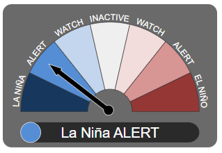
ENSO Outlook moves to La Niña ALERT


The ENSO Outlook has [moved] to La Niña ALERT. This means that even though the El Niño–Southern Oscillation is currently neutral, the chance of La Niña forming in the coming months has increased to around 70%. This is roughly three times the normal likelihood of an event forming in any year.


This status change follows a renewal of cooling in the tropical Pacific Ocean towards La Niña thresholds over recent weeks, as well as the persistence of the Southern Oscillation Index (SOI) at La Niña levels and strengthened trade winds at La Niña levels. Climate models indicate further cooling is likely, with four of seven models suggesting La Niña could return by early-to-mid southern hemisphere spring.


A La Niña ALERT is not a guarantee that La Niña will occur, rather it is an indication that most of the typical precursors of an event are in place. La Niña conditions increase the chance of above average spring and summer rainfall in northern and eastern Australia.


Bureau climatologists will continue to closely monitor conditions in the tropical Pacific as well as model outlooks for further signs of La Niña re-emergence.


"The chance of a La Niña developing in the coming season has increased. When these criteria have been met in the past, a La Niña event has developed around 70% of the time.".....


La Niña Alert


Any three of the following criteria need to be satisfied:


  • Sea surface temperature: A clear cooling trend has been observed in the NINO3 or NINO3.4 regions of the Pacific Ocean during the past three to six months.

  • Winds: Trade winds have been stronger than average in the western or central equatorial Pacific Ocean during any two of the last three months.

  • SOI: The two-month average SOI is +7 or higher.

  • Models: A majority of surveyed climate models show sustained cooling to at least 0.8 °C below average in the NINO3 or NINO3.4 regions of the Pacific Ocean by the late winter or spring.