Showing posts with label forecasts. Show all posts

Friday, 18 October 2024

Seven weeks out from the beginning of the Australian Summer meteorologists were predicting "unusually high temperatures from December through to February


This is an ABC News article extract on 11 October 2024:


Australia is facing one of the hottest summers on record according to the Bureau of Meteorology's (BOM) weather modelling, which tips well-above-average temperatures across the country.


The forecast for a scorching summer is largely due to ongoing high ocean temperatures surrounding Australia, a persistent feature that has plagued most of the globe since early last year.


The warm seas will not only raise air temperatures but also boost atmospheric moisture levels, swinging the odds to favour frequent storm outbreaks and above-average rain.


Our simmering oceans could also lead to the most active cyclone season in years, with the BOM expecting around 11 named storms in the Australian region, including an increased risk of severe (category three or above) systems.


Of the past six years, the three that were not La Niña periods took the top three spots as Australia's hottest summers on record, all with mean temperatures more than 1.6 degrees Celsius above the long-term average.


This trend suggests this summer will also produce well-above-average temperatures — a prediction supported by seasonal modelling.


The BOM's initial summer forecast, released this week, shows a greater than 80 per cent chance of minimum temperatures in the top 20 per cent of years — which the BOM label "unusually high temperatures"....


So how do conditions look now in Spring 2024?


Australian Bureau of Meteorology (BOM):


Weekly sea surface temperatures


PACIFC OCEAN SEA SURFACE HEAT MAP


Weekly temperature anomalies in the tropical Pacific


For the week ending 13 October 2024, sea surface temperatures (SSTs) were:


  • 0.8–2 °C warmer than the 1991–2020 average in the far western and parts of the far eastern equatorial Pacific

  • 0.8–2 °C cooler than average in the central equatorial Pacific

  • warmer than average across much of the north Pacific, with much of the region surrounding and to the east of Japan more than 3–4 °C warmer than average

  • 0.8–2 °C warmer than average around the north-west of Australia's coastline and parts of the Tasman and Coral seas

  • 0.4–1.2 °C warmer than average across most of the Maritime Continent.


The Niño indices for the week ending 13 October 2024 are:

Niño3, −0.1 °C; Niño3.4, −0.5 °C; and Niño4, +0.04 °C. The Niño3.4 index reflects historically neutral ENSO conditions.


5-day sub-surface temperatures


For the 5 days ending 13 October 2024, the analysis shows:


  • sub-surface temperatures around 1 °C cooler than average in the central equatorial Pacific (between 125 m and 200 m depth) and in the eastern equatorial Pacific (between 50 m and 100 m depth).

  • sub-surface temperature anomalies more than 3 °C warmer than average in the shallow eastern equatorial sub-surface (above 50 m depth).


Long-range forecast overview

Issued: 10 October 2024


The long-range forecast for November to January shows:


  • Above average rainfall is likely across much of southern and eastern Australia.

  • Warmer than average days and nights are likely to very likely across most of Australia.

  • Unusually high minimum temperatures are very likely for much of northern and eastern Australia.


Our forecasts have greater accuracy closer to the forecast period. Refer to our weekly updates to follow the evolution of rainfall and temperature patterns as the November to January season approaches.


New South Wales forecast air temperature over land


Max temperature - The chance of above median max temperature for 20 Oct – 2 Nov


Thursday, 12 May 2022

Eight days out from the 21 May 2022 federal general election and much of the NSW Northern Rivers region is on flood watch again


Australian Bureau of Meteorology (BOM):

Flood Watch for the Northern Rivers and Central West

Issued at 12:21 pm EST on Thursday 12 May 2022


Flood Watch Number: 3


MINOR FLOODING POSSIBLE IN THE NORTHERN RIVERS AND CENTRAL WEST FROM THURSDAY


A trough over western inland New South Wales will generate further moderate to heavy rain in many areas of the Central West on Thursday. This may cause minor flooding along the Castlereagh, Macquarie and Bell Rivers from Thursday night.


* Reissue to include Castlereagh *


River level rises have been observed from recent moderate rainfall in the Northern Rivers. Further moderate showers expected on Thursday may see river levels rise to minor flood levels.


Renewed minor flooding is also possible along the Bogan River where a flood warning is current.


The Bureau is continuing to monitor the situation and will issue further catchment specific warnings if and when required.


Catchment soil moisture is average.


The weather system is expected to cause flooding for the catchments listed. Flood Classes (minor, moderate, major) are only defined for catchments where the Bureau provides a flood warning service.


Catchments likely to be affected include:


Tweed and Rouse Rivers - minor flooding 

Brunswick River and Marshalls Creek - minor flooding

Wilsons River - minor flooding

Richmond River - minor flooding

Castlereagh River - minor flooding

Orange, Molong and Bell River - minor flooding

Turon and Macquarie Rivers to Burrendong Dam - minor flooding

Macquarie River d/s Burrendong Dam - minor flooding


Flood warnings are current for the Culgoa, Bokhara, Bogan, Paroo and Warrego Rivers.


For the latest flood and weather warnings see www.bom.gov.au/nsw/warnings/


For the latest rainfall and weather forecasts see www.bom.gov.au/australia/meteye/


For the latest rainfall and river level information see www.bom.gov.au/nsw/flood

 [my yellow highlighting]

~~~~~~~~~~~~~~~~~~~~~~~~~~


There is a chance of above median rainfall across much of the continent from 14 May 2022 to September 2022.


According to BOM long range forecasting there is also a 50-60% chance of the Page and Richmond electorates in the Northern Rivers region being “unusually wet” between 14 to 27 May 2022.


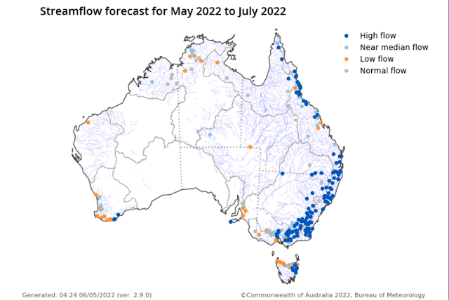
Stream Flow Forecast


Click on image to enlarge


Climate outlook overview

Issued: 5 May 2022


Winter (June to August) rainfall is likely to be above median for most of Australia, except south-western Australia, the south-east coast, and southern Tasmania which have roughly equal chances of being above or below median.

June to August maximum temperatures are likely to be above median for northern, south-western, and south-eastern parts of Australia, but below median for broad areas of inland southern and central Australia.

Minimum temperatures for June to August are very likely to be warmer than median across almost all of Australia.

The weakening La Niña, the chance of a negative Indian Ocean Dipole, and other localised drivers are likely to be influencing this outlook.


Latest Climate Driver Update, 10 May 2022:


La Niña maintains strength


The 2021–22 La Niña event continues in the tropical Pacific, with little change in strength in the past few weeks.


Several indicators of La Niña, including tropical Pacific sea surface temperatures, cloudiness near the Date Line, and the Southern Oscillation Index (SOI), have maintained or slightly increased their strength over the past fortnight. However, beneath the surface of the tropical Pacific, waters have warmed closer to neutral El Niño–Southern Oscillation (ENSO) levels.


Most climate models surveyed by the Bureau indicate a return to neutral ENSO by the early southern hemisphere winter. Only one of seven models continues La Niña conditions through the southern winter. La Niña conditions increase the chances of above average rainfall for much of eastern Australia, while neutral ENSO has little influence on rainfall patterns.


The Indian Ocean Dipole (IOD) is neutral. All climate model outlooks surveyed suggest a negative IOD may develop in the coming months. While model outlooks have low accuracy at this time of year and hence some caution should be taken with IOD outlooks beyond May, there is strong forecast consistency across international models. A negative IOD increases the chances of above average winter–spring rainfall for much of Australia. It also increases the chances of warmer days and nights for northern Australia.


The Southern Annular Mode (SAM) index is currently positive and is forecast to remain positive for the coming four weeks. During autumn SAM typically has a weaker influence on Australian rainfall, but as we approach winter, positive SAM often has a drying influence for parts of south-west and south-east Australia.


The Madden–Julian Oscillation (MJO) has recently strengthened in the western Indian Ocean. Most climate models indicate the MJO will briefly weaken, and then re-strengthen again later this week in the Maritime Continent or western Pacific region. Should the MJO re-strength in the Maritime Continent region, it can enhance rainfall in north-eastern Australia. It also typically increases cloudiness to Australia's north.


Climate change continues to influence Australian and global climate. Australia's climate has warmed by around 1.47 °C for the 1910–2020 period. Southern Australia has seen a reduction of 10–20% in cool season (April–October) rainfall in recent decades. There has also been a trend towards a greater proportion of rainfall from high intensity short duration rainfall events, especially across northern Australia. [my yellow highlighting]


Friday, 26 November 2021

La Niña's arrival in the tropical Pacific may herald high flow river levels on the NSW coast during December 2021


Australian Bureau of Meteorology (BOM):


Climate outlook overview, 18 November 2021:


  • December to February rainfall is likely to be above median for the eastern half of the eastern States, with highest chances along eastern Queensland.

  • There is an increased chance of unusually high rainfall (in the top 20% of historical records) for December to February for parts of the eastern States (1.5 to 2.5 times the usual chance).

  • December to February maximum temperatures are likely to be above median for much of northern and western Australia, as well as parts of the south-east. Below median daytime temperatures are likely for eastern NSW.

  • Minimum temperatures for December to February are likely to be warmer than median for most of Australia, with southern WA and western SA having roughly equal chances of warmer or cooler than median nights.

  • The developing La Niña conditions in the Pacific Ocean, and the La Niña (SAM) phase are likely influencing the above median rainfall outlooks.


 Climate Driver Update, 23 November 2021:


La Niña established in the tropical Pacific


La Niña has become established in the tropical Pacific. The Bureau's ENSO Outlook has been raised to LA NIÑA. Climate models suggest this La Niña will be short-lived, persisting until the late southern hemisphere summer or early autumn 2022. La Niña events increase the chance of above average rainfall across much of northern and eastern Australia during summer.


Several indicators of the El Niño–Southern Oscillation (ENSO) now show clear La Niña patterns. Sea surface temperatures in the tropical Pacific are close to La Niña thresholds, with climate model outlooks expecting them to cool further. In the atmosphere, cloud and wind patterns are typical of La Niña, indicating the atmosphere is now responding to, and reinforcing, the changes observed in the ocean.


The negative Indian Ocean Dipole (IOD) is approaching its end, with oceanic index values in the neutral range. However, cloud and wind patterns across the eastern Indian Ocean suggest some IOD influence remains. All models indicate the IOD will remain neutral for the coming months, consistent with its typical seasonal cycle. A negative IOD increases the chances of above-average spring rainfall for much of southern and eastern Australia.


The Madden–Julian Oscillation (MJO) is currently over the Maritime Continent region at weak to moderate strength. The MJO is forecast to progress eastwards across the Maritime Continent and into the western Pacific over the coming fortnight, increasing the chances of above average rainfall across northern Australia and the Maritime Continent, to Australia's north.


The Southern Annular Mode (SAM) has generally been positive for several weeks. It is forecast to remain at positive levels to the end of the year. A positive SAM during summer typically brings wetter weather to eastern parts of Australia, but drier than average conditions for western Tasmania.


Climate change continues to influence Australian and global climate. Australia's climate has warmed by around 1.44 °C for the 1910–2019 period. Rainfall across northern Australia during its wet season (October–April) has increased since the late 1990s. In recent decades there has been a trend towards a greater proportion of rainfall from high intensity short duration rainfall events, especially across northern Australia.