Showing posts with label La Niña. Show all posts

Thursday 26 May 2022

Communities in the seven local government areas of the NSW Northern Rivers region know where they have been in 2022 and now they know where they are heading - into more rain


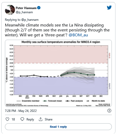
ENSO Outlook
An alert system for the El Niño–Southern Oscillation, 24 May 2022


Australian Bureau of Meteorology:


Special Climate Statement 76 - Extreme rainfall and flooding in south-east Queensland and eastern New South Wales, February-March 2022

25/05/2022 - National


Issued at 10:30am, Wednesday 25 May 2022


The Bureau of Meteorology has released a formal record of the extreme rainfall and flooding that occurred in south-east Queensland and eastern New South Wales in February and March this year.


Special Climate Statement 76 outlines that several rainfall records were broken between 22 February and 9 March 2022, with more than 50 sites recording more than one metre of rainfall in one week.


In the last week of February, parts of south-east Queensland and north-east New South Wales had rainfall 2.5 times their monthly average with some regions recording more than five times their monthly average.


After two years of La Niña conditions, the rain fell on saturated catchments leading to flash and riverine flooding extending from Maryborough in Queensland to Grafton in New South Wales.


For many areas, this was the wettest week since at least 1900. Some areas of south-eastern Queensland had their highest flood peaks since 1893, though the lower Brisbane and Bremer rivers and Lockyer Creek peaked below the levels of both January 1974 and January 2011 floods.


In parts of northern New South Wales, flood levels broke previous records. Wilsons River in Lismore peaked at a record high level, estimated to be 14.4 m on 28 February. The previous record was 12.27 m in February 1954.


The rainfall was the result of a combination of weather systems over eastern Australia and the Tasman Sea, where a large volume of humid tropical air moving onshore over eastern Australia was lifted in the atmosphere to produce heavy rain and thunderstorms.


In recent decades, there has been a trend towards a greater proportion of high-intensity, short-duration rainfall events, especially across northern Australia.


The Bureau's special climate statements provide detailed summaries of significant weather and climate events that impact Australians. This Special Climate Statement has been added to an archive of Special Climate Statements dating back more than 15 years, providing easy access to data and information.


Special Climate Statement 76 can be found here: http://www.bom.gov.au/climate/current/statements


The Guardian, 25 May 2022:


The breakdown of the La Niña weather pattern in the Pacific has stalled while a key Indian Ocean climate driver is tilting towards its wetter phase, making it more likely that eastern Australia will face more heavy rain and floods.


Just as the Bureau of Meteorology released a special climate report on the extreme rainfall and flooding that hit parts of south-eastern Queensland, northern New South Wales and the region around Sydney in February and March, its fortnightly report on climate influences pointed to the big wet extending for months to come.


The La Niña event, already in its second year, could yet persist into a third. The expected dissipation of the pattern has not progressed in the past two weeks, and two of the seven models used by the bureau project that the La Niña will last through winter.


Out west, the Indian Ocean dipole is forecast by all climate models to enter its negative phase in coming months.


That phase of the dipole – which gauges the relative differences of sea-surface temperatures across the ocean – increases the chances of above-average winter-spring rainfall for much of Australia. It also lifts the odds of warmer days and nights for northern Australia, according to the bureau.


The prospect of wetter than normal conditions for the east coast in particular will prompt fears of further floods. Catchments remain damp and dams are full, so it won’t require significant bursts of rain to cause more flash flooding and damage.


Read the full article here.


Sunday 5 December 2021

Australian Prime Minister Scott Morrison is back trying to pretend the politically inconvenient fact of climate change is not occurring in the leadup to the 2022 federal election


Australian Bureau of Meteorology


On 5 November 2021 Australian Prime Minister & Liberal MP for Cook (NSW) Scott Morrison issued a lengthy media statement which ended with these three lines:


High Risk Weather Events

National Cabinet received a briefing from Emergency Management Australia on the 2021-22 High Risk Weather Season, and noted that a La Niña watch has been issued in 2021.”


NOTE: Emergency Management Australia falls within the Dept. of Home Affairs. It organises the National Catastrophic Natural Disaster Plan (NATCATDISPLAN) last updated in 2017, republished in 2020.


To be honest I did not think why those three lines had been tacked on at the end of a statement which covered Vaccination and Booster Plans, Ensuring COVID-19 Outbreak Readiness for Indigenous Communities, National Plan to Transition Australia’s COVID-19 Response, Living with COVID-19 - Revised Test, Trace, Isolate and Quarantine (TTIQ) and Public Health and Social Measures (PHSMs), Living with COVID-19 - Health System Capacity, Borders and International Travel, along with this live link Doherty Institute COVID-19 modelling: 2nd tranche [PDF 651 KB].


At most all I thought was ‘Oh yes, the La Niña ALERT. North Coast Voices covered that in October and November posts'.


What I didn’t know and the Prime Minister did, was that the Australian Bureau of Meteorology had put together a rather more pointed weather outlook and forecast in power point form, which brought together the dry technical language on its website & its YouTube videos in a way that clearly showed where climate change had landed us all in 2021-22.


It must have been as obvious to the Prime Minister, as it was to me once I sighted segments of that presentation, that this was not information that a notorious climate change trivialising federal government would want to highlight going into an election year. However, as a slippery, slithering game player who is always looking for plausible deniability, those three brief lines would allow Morrison to say 'but I told Australia about it!' if a journalist thought to ask.


Here are a selection of slides from that presentation courtesy of Senator Rex Patrick’s Twitter account:


Click on images to enlarge.


The Guardian, 4 December 2021:


Tropical cyclones and flooding are set to pummel Australia over summer, national cabinet documents reveal.


The Bureau of Meteorology briefed the meeting of premiers, chief ministers and the prime minister on 5 November about the high-risk weather facing the nation until April.


National cabinet documents are usually kept secret, but South Australian senator Rex Patrick obtained these under freedom-of-information laws.


Last week Patrick, the Labor leader, Anthony Albanese, and One Nation’s Malcolm Roberts all launched attacks on the prime minister’s department for its secrecy. There is a broader legal question about whether national cabinet is entitled to the cabinet-in-confidence protection, with critics saying that merely calling it a cabinet does not actually make it one.


The bureau director general, Joe Buffone, presented Emergency Management Australia’s 2021-22 High Risk Weather Season briefing.


The PowerPoint presentation shows there are increased chances of widespread flooding, coastal flooding and erosion, tropical cyclones and marine heatwaves, compared with average summers and early autumns.


There is a lower chance of drought and dust.


The overall risk of severe storms is on par with other years, while parts of Queensland and NSW have an increased risk of bushfire, and there is a higher chance of heatwaves than usual.


Warm waters mean slightly above average tropical cyclone numbers – the average is 11 per season.


La Niña means the weather is likely to be cooler, wetter and stormier. Areas that had above-average rainfall during spring, and therefore more grass, could lead to a heightened grassfire risk, while parts of the east coast will have a lower risk – because the 2019-20 fires reduced fuel loads.


The bureau’s presentation was prepared with publicly available information.


Patrick said the prime minister, Scott Morrison, should have released the documents when he released a media statement about the national cabinet meeting. That statement focused almost entirely on Covid, with a single line about the briefing.


That line prompted Patrick to make the FOI request to the Department of Home Affairs…….


And so it starts.


NSW and Victoria floods: rivers break banks as rain and wind lash Australia’s eastern states, The Guardian, 13 November 2021.


NSW flood damage bill expected to exceed $1b as November rain submerges crops, ABC News, 1 December 2021.


Man dies in Queensland floodwaters as heavy rainfall causes Inglewood to be evacuated, cars swept off road in state's south, ABC News, 1 December 2021.


BOM issues flood warning for Chinchilla on the Western Downs, as parts of southern Queensland begin clean-up, ABC News, 3 December 2021.


Friday 26 November 2021

La Niña's arrival in the tropical Pacific may herald high flow river levels on the NSW coast during December 2021


Australian Bureau of Meteorology (BOM):


Climate outlook overview, 18 November 2021:


  • December to February rainfall is likely to be above median for the eastern half of the eastern States, with highest chances along eastern Queensland.

  • There is an increased chance of unusually high rainfall (in the top 20% of historical records) for December to February for parts of the eastern States (1.5 to 2.5 times the usual chance).

  • December to February maximum temperatures are likely to be above median for much of northern and western Australia, as well as parts of the south-east. Below median daytime temperatures are likely for eastern NSW.

  • Minimum temperatures for December to February are likely to be warmer than median for most of Australia, with southern WA and western SA having roughly equal chances of warmer or cooler than median nights.

  • The developing La Niña conditions in the Pacific Ocean, and the La Niña (SAM) phase are likely influencing the above median rainfall outlooks.


 Climate Driver Update, 23 November 2021:


La Niña established in the tropical Pacific


La Niña has become established in the tropical Pacific. The Bureau's ENSO Outlook has been raised to LA NIÑA. Climate models suggest this La Niña will be short-lived, persisting until the late southern hemisphere summer or early autumn 2022. La Niña events increase the chance of above average rainfall across much of northern and eastern Australia during summer.


Several indicators of the El Niño–Southern Oscillation (ENSO) now show clear La Niña patterns. Sea surface temperatures in the tropical Pacific are close to La Niña thresholds, with climate model outlooks expecting them to cool further. In the atmosphere, cloud and wind patterns are typical of La Niña, indicating the atmosphere is now responding to, and reinforcing, the changes observed in the ocean.


The negative Indian Ocean Dipole (IOD) is approaching its end, with oceanic index values in the neutral range. However, cloud and wind patterns across the eastern Indian Ocean suggest some IOD influence remains. All models indicate the IOD will remain neutral for the coming months, consistent with its typical seasonal cycle. A negative IOD increases the chances of above-average spring rainfall for much of southern and eastern Australia.


The Madden–Julian Oscillation (MJO) is currently over the Maritime Continent region at weak to moderate strength. The MJO is forecast to progress eastwards across the Maritime Continent and into the western Pacific over the coming fortnight, increasing the chances of above average rainfall across northern Australia and the Maritime Continent, to Australia's north.


The Southern Annular Mode (SAM) has generally been positive for several weeks. It is forecast to remain at positive levels to the end of the year. A positive SAM during summer typically brings wetter weather to eastern parts of Australia, but drier than average conditions for western Tasmania.


Climate change continues to influence Australian and global climate. Australia's climate has warmed by around 1.44 °C for the 1910–2019 period. Rainfall across northern Australia during its wet season (October–April) has increased since the late 1990s. In recent decades there has been a trend towards a greater proportion of rainfall from high intensity short duration rainfall events, especially across northern Australia.


Thursday 14 October 2021

A southern low pressure system and a La Niña ALERT are not warmly welcomed news for the NSW North Coast, as it's possible some heavy rain events could occur between now and January 2022


Ch 9 News on 13 October 2021 reported; Meteorologists warn a "beast from the south" will produce a dangerous mix of heavy rain, severe thunderstorms, damaging winds, hail and snow over Australia's south-east as a week of spring wet weather continues.


Coastal catchments with much of their historical and ongoing development situated on floodplains are particularly vulnerable when a climate driver triggers prolonged or frequent heavy rainfall events, as widespread or flash flooding can result. Property damage, stock & crop losses may occur and, sometimes the deaths of people caught in flood waters. 


Similarly low pressure systems can batter coastal catchments.


WeatherZone tweeted this.....


This was the Australian Bureau of Meteorology (BOM), on 12 October 2021:


The Bureau's ENSO Outlook has been raised to La Niña ALERT. This is due to continued cooling in the tropical Pacific Ocean and an increase in the number of climate models showing sustained La Niña conditions over summer. Historically, when La Niña ALERT criteria have been met, La Niña has subsequently developed around 70% of the time. A 70% chance of an event is approximately triple the normal likelihood. La Niña events increase the chances of above-average rainfall for northern and eastern Australia during spring and summer.


Most oceanic and atmospheric indicators of ENSO are currently within the ENSO-neutral range, but some have shifted towards a La Niña-like state. Sea surface temperatures in the central tropical Pacific Ocean are neutral, but have cooled over the past three months and are supported by cooler than average waters beneath the surface. Some atmospheric indicators, such as the Southern Oscillation Index (SOI) and cloudiness near the Date Line, are approaching La Niña levels. Six of the seven international climate models surveyed by the Bureau meet La Niña criteria from November.


A weak negative Indian Ocean Dipole (IOD) event continues. Most models suggest the negative IOD event will ease to neutral levels in late spring. A negative IOD increases the chances of above-average spring rainfall for much of southern and eastern Australia, while a neutral IOD has little influence on Australian climate.


The Madden–Julian Oscillation (MJO) has been active over the Maritime Continent since late September. The MJO is forecast to progress eastwards over the coming week and weaken as it approaches the western Pacific. While the MJO is over the Maritime Continent region, it encourages enhanced rainfall over the tropics to the north of Australia.


The Southern Annular Mode (SAM) index has been neutral for the past week after 5 to 6 weeks at positive levels. While it is forecast to remain neutral for the coming week, it is expected to return to generally positive levels from October to December. A positive SAM during spring typically brings wetter weather to eastern parts of Australia, but drier than average conditions for western Tasmania.


Climate change continues to influence Australian and global climate. Australia's climate has warmed by around 1.44 °C for the 1910–2019 period. Rainfall across northern Australia during its wet season (October–April) has increased since the late 1990s. In recent decades there has been a trend towards a greater proportion of rainfall from high intensity short duration rainfall events, especially across northern Australia.......


The El Niño–Southern Oscillation (ENSO) is currently neutral.


However, all of the seven international climate models surveyed by the Bureau anticipate further cooling of tropical Pacific sea surface temperatures. All models surveyed indicate La Niña thresholds may be met during November. Six of the seven models indicate this cooling will be sustained at La Niña levels until at least January 2022—long enough to meet minimum La Niña event criteria (i.e. at least three months). Four models continue the event into February, but by March only two models continue to meet the threshold.


La Niña typically enhances spring rainfall in northern and eastern Australia.


BACKGROUND


Major floods frequently isolate towns, and can cause death, major disruptions to road and rail links, the evacuation of many houses and business premises, and the widespread flooding of farmland…..

As we are specifically concerned with major flooding near the coast, we consider a flood to be major if (i) it causes inundation of a river within approximately 50 km of the coast or (ii) if there is non-riverine flooding overland near the coast, from the active part of a weather system, that extends at least 20 km along the coast. In (i) extreme rainfall extends well into the hinterland and the upper reaches of the river catchments, causing a flood that drains down the river systems to coastal areas. In (ii) extreme rainfall is confined to the coast and floods form directly over the coastal area rather than propagating down the river systems. At major coastal centres there are official river height records that determine whether a flood meets the major level or not, and we have used this data available.” [ResearhGate, Callaghan J & Scott, S in Australian Meteorological and Oceanographic Journal 64(3):183-21 DOI:10.22499/2.6403.002]


On Australia’s eastern shores East Coast Lows are also often a trigger for heavy rainfall and widespread flooding. Sea surface temperature gradients associated with the warm eddies of the East Australian Current are an important contributor to the development of the lows.


Tuesday 23 March 2021

Widespread rain set to continue into next week across much of Australia


ABC News, 22 March 2021:


BOM warns more wild weather to come as tropical cloud band collides with east coast trough


Heavy rainfall is expected to continue in the coming days before starting to ease off Wednesday.
(

Supplied: Bureau Of Meteorology

)


"Absolutely incredible" totals are set to continue as weather systems collide, bringing a peak to the rain overnight and into tomorrow morning.


Every state and territory, except Western Australia, is expected to be under some sort of heavy rain warning by this evening.


Very dangerous conditions continue for flood-affected areas as another 50 to 100 millimetres is expected to fall on already swollen catchments today…...


Go to https://www.livetraffic.com/ for updates on NSW road and bridge closures due to flooding, as well as roads with poor driving conditions.

Monday 14 December 2020

Comes December 2020, comes a La Niña rain dump


This was the outlook on the NSW North Coast last Saturday evening…..


The Sydney Morning Herald, 12 December 2020:


Tens of thousands of residents in northern NSW were on high alert on Saturday evening ahead of wild weather expected to arrive late on Sunday and into Monday.


Sandbagging was under way and some residents were relocating to higher ground as the Mid North Coast and Northern Rivers regions braces for torrential rainfall and potential major flooding over the next 48 hours.


A deepening trough over the state was also expected to be accompanied by damaging winds gusting up to 90km/h and a damaging surf as waves were set to exceed five metres.


The Bureau of Meteorology has warned abnormally high tides could lead to coastal inundation and significant beach erosion north from Ballina.


It said rainfall was likely to be heavier in localities affected by severe thunderstorms. "This may lead to dangerous flash flooding,” it said.


The community of Ocean Shores, near Byron Bay, was caught without warning by flash flooding on Saturday afternoon.


An hour of pelting rain saw the streets inundated with whitewater in the coastal town.


The greatest concern in NSW looking ahead is for low lying properties that flank the Bellinger River, south of Coffs Harbour…..


The NSW SES urged people in flood-prone parts of the Bellingen region to relocate to the homes of family or friends outside the impact area….


A string of other areas across the Mid North Coast and Northern Rivers were also on flood watch on Saturday.


Catchments likely to be affected include:

Tweed and Rouse Rivers minor to moderate flooding

Brunswick River and Marshalls Creek minor flooding

Wilsons River minor to moderate flooding

Richmond River minor flooding

Orara River moderate flooding

Coffs Coast minor flooding

Nambucca River minor to moderate flooding

Hastings River minor flooding

Authorities warned high water levels due to spring tides added to the risk of flooding in low lying areas…...


From Friday 11 to Saturday 12 December, although at least 108mm of rain had fallen on the Clarence Coast and at least 125mm inland in the Grafton area, the rain had not been accompanied by destructive storms and the Clarence River system was in no danger of heavy flooding.


Evans Head on the coast which received 158.6mm of rain in the same period appeared to be weathering the rain dump reasonably well.


Early Monday morning after a day and night of continuing rain, strong winds, high seas and king tides the northern coastline of New South Wales was bruised and battered.


Gale warnings continue for waters from the Coffs Coast up to the Tweed Coast and into south-east Queensland.

The rain dump continues to sit on top of north-east NSW and the Bureau of Meteorology states that more heavy rainfall is expected, along with:

DAMAGING WINDS, with winds averaging 60-70 km/h and gusts exceeding 90 km/h are possible along the coastal fringe north from about Yamba, possibly extending south to about Crescent Head on the Mid North Coast during the day. 

DAMAGING SURF, with waves exceeding 5 metres in the surf zone can be expected, extending south to Port Macquarie during the day, possibly leading to significant beach erosion. 

ABNORMALLY HIGH TIDES are expected along the coast north from about Ballina during this morning's high tide, which may lead to localised coastal inundation. The combination of Damaging Surf and Abnormally High Tides may enhance the risk of significant beach erosion north from about Ballina. 

A Flood Watch is current for the Mid North Coast and Northern Rivers and Flood Warnings have been issued for the Tweed, Wilsons, Bellinger and Brunswick Rivers, 

See http://www.bom.gov.au/nsw/warnings/ for the latest Flood Watch/Warnings. 

Locations which may be affected include Tweed Heads, Byron Bay, Lismore, Grafton, Coffs Harbour, Port Macquarie, Sawtell and Dorrigo.

Overnight, there were over 700 SES call-outs along the Mid North and Far North Coast regions. 

As yet the NSW Road Traffic Authority is not reporting any road closures for main roads and highways.

It is being reported that by Tuesday 15 December 2020, three day totals of 300-600 ml are predicted to fall across the North Coast.