Flood
Watch for the Northern Rivers and Central West
Issued
at 12:21 pm EST on Thursday 12 May 2022
Flood
Watch Number: 3
MINOR
FLOODING POSSIBLE IN THE NORTHERN RIVERS AND CENTRAL WEST FROM
THURSDAY
A
trough over western inland New South Wales will generate further
moderate to heavy rain in many areas of the Central West on Thursday.
This may cause minor flooding along the Castlereagh, Macquarie and
Bell Rivers from Thursday night.
*
Reissue to include Castlereagh *
River
level rises have been observed from recent moderate rainfall in the
Northern Rivers. Further moderate showers expected on Thursday may
see river levels rise to minor flood levels.
Renewed
minor flooding is also possible along the Bogan River where a flood
warning is current.
The
Bureau is continuing to monitor the situation and will issue further
catchment specific warnings if and when required.
Catchment
soil moisture is average.
The
weather system is expected to cause flooding for the catchments
listed. Flood Classes (minor, moderate, major) are only defined for
catchments where the Bureau provides a flood warning service.
Catchments
likely to be affected include:
Tweed
and Rouse Rivers - minor flooding
Brunswick
River and Marshalls Creek - minor flooding
Wilsons
River - minor flooding
Richmond
River - minor flooding
Castlereagh
River - minor flooding
Orange,
Molong and Bell River - minor flooding
Turon
and Macquarie Rivers to Burrendong Dam - minor flooding
Macquarie
River d/s Burrendong Dam - minor flooding
Flood
warnings are current for the Culgoa, Bokhara, Bogan, Paroo and
Warrego Rivers.
For
the latest flood and weather warnings see
www.bom.gov.au/nsw/warnings/
For
the latest rainfall and weather forecasts see
www.bom.gov.au/australia/meteye/
For
the latest rainfall and river level information see
www.bom.gov.au/nsw/flood
[my yellow highlighting]
~~~~~~~~~~~~~~~~~~~~~~~~~~
There
is a chance
of above median rainfall across much of the continent from 14 May
2022 to September 2022.
According
to BOM long range forecasting there
is also a
50-60% chance of the Page
and Richmond electorates in the Northern Rivers region being
“unusually wet” between 14 to 27 May 2022.
Stream
Flow Forecast
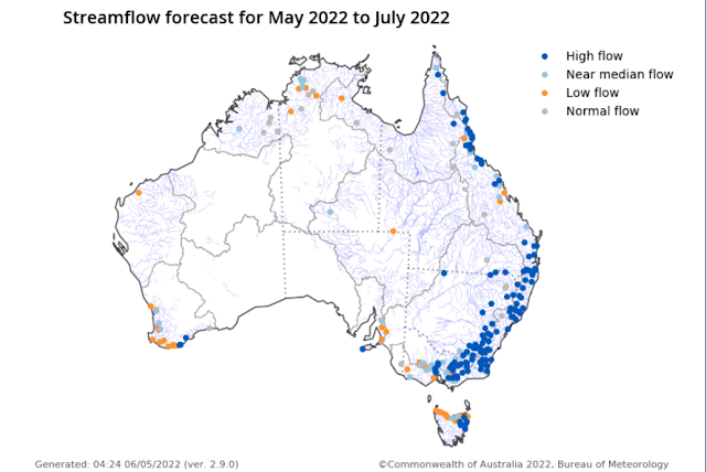 |
Click on image to enlarge
|
Climate
outlook overview
Issued:
5 May 2022
Winter
(June to August) rainfall is likely to be above median for most of
Australia, except south-western Australia, the south-east coast, and
southern Tasmania which have roughly equal chances of being above or
below median.
June
to August maximum temperatures are likely to be above median for
northern, south-western, and south-eastern parts of Australia, but
below median for broad areas of inland southern and central
Australia.
Minimum
temperatures for June to August are very likely to be warmer than
median across almost all of Australia.
The
weakening La Niña, the chance of a negative Indian Ocean Dipole, and
other localised drivers are likely to be influencing this outlook.
Latest
Climate Driver Update,
10 May 2022:
La
Niña maintains strength
The
2021–22 La Niña event continues in the tropical Pacific, with
little change in strength in the past few weeks.
Several
indicators of La Niña, including tropical Pacific sea surface
temperatures, cloudiness near the Date Line, and the Southern
Oscillation Index (SOI), have maintained or slightly increased their
strength over the past fortnight. However, beneath the surface of the
tropical Pacific, waters have warmed closer to neutral El
Niño–Southern Oscillation (ENSO) levels.
Most
climate models surveyed by the Bureau indicate a return to neutral
ENSO by the early southern hemisphere winter. Only one of seven
models continues La Niña conditions through the southern winter. La
Niña conditions increase the chances of above average rainfall for
much of eastern Australia, while neutral ENSO has little influence on
rainfall patterns.
The
Indian Ocean Dipole (IOD) is neutral. All climate model outlooks
surveyed suggest a negative IOD may develop in the coming months.
While model outlooks have low accuracy at this time of year and hence
some caution should be taken with IOD outlooks beyond May, there is
strong forecast consistency across international models. A negative
IOD increases the chances of above average winter–spring rainfall
for much of Australia. It also increases the chances of warmer days
and nights for northern Australia.
The
Southern Annular Mode (SAM) index is currently positive and is
forecast to remain positive for the coming four weeks. During autumn
SAM typically has a weaker influence on Australian rainfall, but as
we approach winter, positive SAM often has a drying influence for
parts of south-west and south-east Australia.
The
Madden–Julian Oscillation (MJO) has recently strengthened in the
western Indian Ocean. Most climate models indicate the MJO will
briefly weaken, and then re-strengthen again later this week in the
Maritime Continent or western Pacific region. Should the MJO
re-strength in the Maritime Continent region, it can enhance rainfall
in north-eastern Australia. It also typically increases cloudiness to
Australia's north.
Climate
change continues to influence Australian and global climate.
Australia's climate has warmed by around 1.47 °C for the 1910–2020
period. Southern Australia has seen a reduction of 10–20% in cool
season (April–October) rainfall in recent decades. There has also
been a trend towards a greater proportion of rainfall from high
intensity short duration rainfall events, especially across northern
Australia. [my yellow highlighting]
.png)


